guideline and standards for skytem measurements, processing and ...
guideline and standards for skytem measurements, processing and ...
guideline and standards for skytem measurements, processing and ...

You also want an ePaper? Increase the reach of your titles
YUMPU automatically turns print PDFs into web optimized ePapers that Google loves.
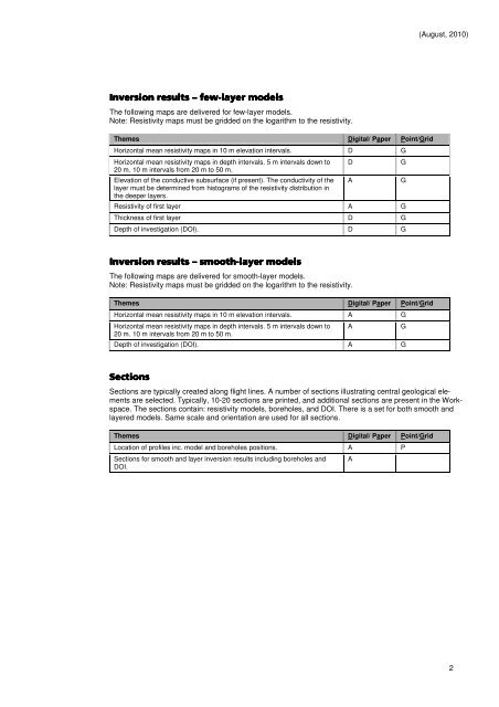
(August, 2010)<br />
<br />
<br />
!"<br />
The following maps are delivered <strong>for</strong> few-layer models.<br />
Note: Resistivity maps must be gridded on the logarithm to the resistivity.<br />
Themes Digital/ Paper Point/Grid<br />
Horizontal mean resistivity maps in 10 m elevation intervals. D G<br />
Horizontal mean resistivity maps in depth intervals. 5 m intervals down to<br />
20 m. 10 m intervals from 20 m to 50 m.<br />
Elevation of the conductive subsurface (if present). The conductivity of the<br />
layer must be determined from histograms of the resistivity distribution in<br />
the deeper layers.<br />
Resistivity of first layer A G<br />
Thickness of first layer D G<br />
Depth of investigation (DOI). D G<br />
D<br />
A<br />
G<br />
G<br />
<br />
!#<br />
!# !"<br />
The following maps are delivered <strong>for</strong> smooth-layer models.<br />
Note: Resistivity maps must be gridded on the logarithm to the resistivity.<br />
Themes Digital/ Paper Point/Grid<br />
Horizontal mean resistivity maps in 10 m elevation intervals. A G<br />
Horizontal mean resistivity maps in depth intervals. 5 m intervals down to<br />
20 m. 10 m intervals from 20 m to 50 m.<br />
Depth of investigation (DOI). A G<br />
A<br />
G<br />
<br />
Sections are typically created along flight lines. A number of sections illustrating central geological elements<br />
are selected. Typically, 10-20 sections are printed, <strong>and</strong> additional sections are present in the Workspace.<br />
The sections contain: resistivity models, boreholes, <strong>and</strong> DOI. There is a set <strong>for</strong> both smooth <strong>and</strong><br />
layered models. Same scale <strong>and</strong> orientation are used <strong>for</strong> all sections.<br />
Themes Digital/ Paper Point/Grid<br />
Location of profiles inc. model <strong>and</strong> boreholes positions. A P<br />
Sections <strong>for</strong> smooth <strong>and</strong> layer inversion results including boreholes <strong>and</strong><br />
DOI.<br />
A<br />
2