California Rapid Assessment Method for Wetlands - State Water ...
California Rapid Assessment Method for Wetlands - State Water ...
California Rapid Assessment Method for Wetlands - State Water ...

You also want an ePaper? Increase the reach of your titles
YUMPU automatically turns print PDFs into web optimized ePapers that Google loves.
<strong>Cali<strong>for</strong>nia</strong> <strong>Rapid</strong> <strong>Assessment</strong> <strong>Method</strong> <strong>for</strong> <strong>Wetlands</strong> v. 5.0.2 – Chapter 3<br />
3.2.2.1 Riverine (Including Closely Associated Riparian Areas)<br />
A riverine wetland consists of the riverine channel and its active floodplain, plus any portions of<br />
the adjacent riparian areas that are likely to be strongly linked to the channel or floodplain<br />
through bank stabilization and allochthanous inputs (see Section 3.5.3 below). An active<br />
floodplain is defined as the relatively level area that is periodically flooded, as evidenced by<br />
deposits of fine sediment, wrack lines, vertical zonation of plant communities, etc. The water<br />
level that corresponds to incipient flooding can vary depending on flow regulation and whether<br />
the channel is in equilibrium with water supplies and sediment supplies. Under equilibrium<br />
conditions, the usual high water contour that marks the inboard margin of the floodplain (i.e.,<br />
the margin nearest the thalweg of the channel) corresponds to the height of bankfull flow, which<br />
has a recurrence interval of about 1.5 to 2.0 years. The active floodplain can include broad areas<br />
of vegetated and non-vegetated bars and low benches among the distributaries of deltas and<br />
braided channel systems. Vegetated wetlands can develop along the channel bottoms of<br />
intermittent and ephemeral streams during the dry season. Dry season assessment in these<br />
systems there<strong>for</strong>e includes the channel beds. However, the channel bed is excluded from the<br />
assessment when it contains non-wadeable flow.<br />
There may be a limit to the applicability of CRAM in low order (i.e., headwater) streams in very<br />
arid environments that tend not to support species-rich plant communities with complex<br />
horizontal and vertical structure. CRAM may be systematically biased against such naturally<br />
simple riverine systems. There<strong>for</strong>e, while the current version of CRAM can be used in these<br />
systems, the results will be tracked carefully. If warranted, the riverine CRAM module will be<br />
revised based on past experience and additional field work during FY 2008-10.<br />
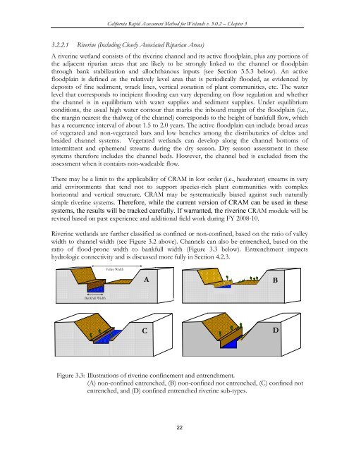
Riverine wetlands are further classified as confined or non-confined, based on the ratio of valley<br />
width to channel width (see Figure 3.2 above). Channels can also be entrenched, based on the<br />
ratio of flood-prone width to bankfull width (Figure 3.3 below). Entrenchment impacts<br />
hydrologic connectivity and is discussed more fully in Section 4.2.3.<br />
Valley Width<br />
A<br />
B<br />
Bankfull Width<br />
C<br />
D<br />
Figure 3.3: Illustrations of riverine confinement and entrenchment.<br />
(A) non-confined entrenched, (B) non-confined not entrenched, (C) confined not<br />
entrenched, and (D) confined entrenched riverine sub-types.<br />
22