California Rapid Assessment Method for Wetlands - State Water ...
California Rapid Assessment Method for Wetlands - State Water ...
California Rapid Assessment Method for Wetlands - State Water ...

Create successful ePaper yourself
Turn your PDF publications into a flip-book with our unique Google optimized e-Paper software.
<strong>Cali<strong>for</strong>nia</strong> <strong>Rapid</strong> <strong>Assessment</strong> <strong>Method</strong> <strong>for</strong> <strong>Wetlands</strong> v. 5.0.2 – Chapter 4<br />
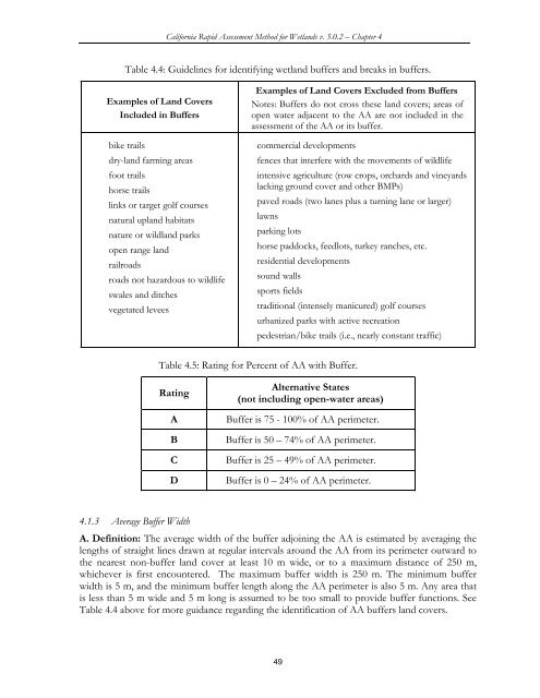
Table 4.4: Guidelines <strong>for</strong> identifying wetland buffers and breaks in buffers.<br />
Examples of Land Covers<br />
Included in Buffers<br />
• bike trails<br />
• dry-land farming areas<br />
• foot trails<br />
• horse trails<br />
• links or target golf courses<br />
• natural upland habitats<br />
• nature or wildland parks<br />
• open range land<br />
• railroads<br />
• roads not hazardous to wildlife<br />
• swales and ditches<br />
• vegetated levees<br />
Examples of Land Covers Excluded from Buffers<br />
Notes: Buffers do not cross these land covers; areas of<br />
open water adjacent to the AA are not included in the<br />
assessment of the AA or its buffer.<br />
• commercial developments<br />
• fences that interfere with the movements of wildlife<br />
• intensive agriculture (row crops, orchards and vineyards<br />
lacking ground cover and other BMPs)<br />
• paved roads (two lanes plus a turning lane or larger)<br />
• lawns<br />
• parking lots<br />
• horse paddocks, feedlots, turkey ranches, etc.<br />
• residential developments<br />
• sound walls<br />
• sports fields<br />
• traditional (intensely manicured) golf courses<br />
• urbanized parks with active recreation<br />
• pedestrian/bike trails (i.e., nearly constant traffic)<br />
Table 4.5: Rating <strong>for</strong> Percent of AA with Buffer.<br />
Rating<br />
A<br />
B<br />
C<br />
D<br />
Alternative <strong>State</strong>s<br />
(not including open-water areas)<br />
Buffer is 75 - 100% of AA perimeter.<br />
Buffer is 50 – 74% of AA perimeter.<br />
Buffer is 25 – 49% of AA perimeter.<br />
Buffer is 0 – 24% of AA perimeter.<br />
4.1.3 Average Buffer Width<br />
A. Definition: The average width of the buffer adjoining the AA is estimated by averaging the<br />
lengths of straight lines drawn at regular intervals around the AA from its perimeter outward to<br />
the nearest non-buffer land cover at least 10 m wide, or to a maximum distance of 250 m,<br />
whichever is first encountered. The maximum buffer width is 250 m. The minimum buffer<br />
width is 5 m, and the minimum buffer length along the AA perimeter is also 5 m. Any area that<br />
is less than 5 m wide and 5 m long is assumed to be too small to provide buffer functions. See<br />
Table 4.4 above <strong>for</strong> more guidance regarding the identification of AA buffers land covers.<br />
49