California Rapid Assessment Method for Wetlands - State Water ...
California Rapid Assessment Method for Wetlands - State Water ...
California Rapid Assessment Method for Wetlands - State Water ...

You also want an ePaper? Increase the reach of your titles
YUMPU automatically turns print PDFs into web optimized ePapers that Google loves.
<strong>Cali<strong>for</strong>nia</strong> <strong>Rapid</strong> <strong>Assessment</strong> <strong>Method</strong> <strong>for</strong> <strong>Wetlands</strong> v. 5.0.2 – Chapter 4<br />
4.4.2 Horizontal Interspersion and Zonation<br />
A. Definition: Horizontal biotic structure refers to the variety and interspersion of plant<br />
“zones.” Plant zones are plant monocultures or obvious multi-species associations that are<br />
arrayed along gradients of elevation, moisture, or other environmental factors that seem to affect<br />
the plant community organization in plan view. Interspersion is essentially a measure of the<br />
number of distinct plant zones and the amount of edge between them.<br />
B. Rationale: The existence of multiple horizontal plant zones indicates a well-developed plant<br />
community and predictable sedimentary and bio-chemical processes. The amount of<br />
interspersion among these plant zones is indicative of the spatial heterogeneity of these<br />
processes. Richer native communities of plants and animals tend to be associated with greater<br />
zonation and more interspersion of the plant zones.<br />
C. Seasonality: This metric is not sensitive to seasonality.<br />
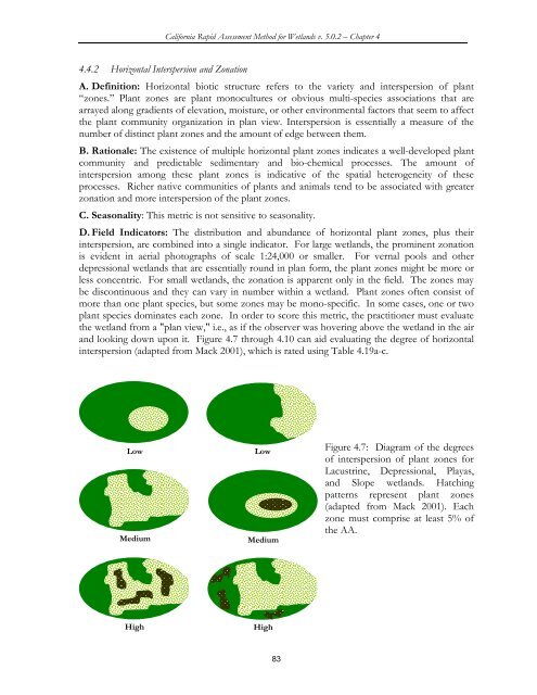
D. Field Indicators: The distribution and abundance of horizontal plant zones, plus their<br />
interspersion, are combined into a single indicator. For large wetlands, the prominent zonation<br />
is evident in aerial photographs of scale 1:24,000 or smaller. For vernal pools and other<br />
depressional wetlands that are essentially round in plan <strong>for</strong>m, the plant zones might be more or<br />
less concentric. For small wetlands, the zonation is apparent only in the field. The zones may<br />
be discontinuous and they can vary in number within a wetland. Plant zones often consist of<br />
more than one plant species, but some zones may be mono-specific. In some cases, one or two<br />
plant species dominates each zone. In order to score this metric, the practitioner must evaluate<br />
the wetland from a "plan view," i.e., as if the observer was hovering above the wetland in the air<br />
and looking down upon it. Figure 4.7 through 4.10 can aid evaluating the degree of horizontal<br />
interspersion (adapted from Mack 2001), which is rated using Table 4.19a-c.<br />
Low<br />
Medium<br />
Low<br />
Medium<br />
Figure 4.7: Diagram of the degrees<br />
of interspersion of plant zones <strong>for</strong><br />
Lacustrine, Depressional, Playas,<br />
and Slope wetlands. Hatching<br />
patterns represent plant zones<br />
(adapted from Mack 2001). Each<br />
zone must comprise at least 5% of<br />
the AA.<br />
High<br />
High<br />
83