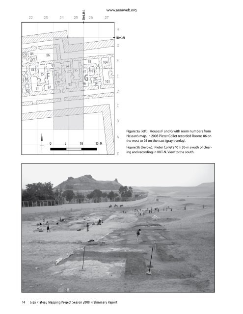
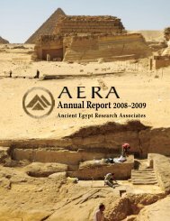
www.aeraweb.org wall (the “Glacis”) bounds the Ante-town on the east (fig. 4, Color Plate 1). At the northern end of the Ante-town the Vestibule, with four alabaster column bases, opens to the Ramp. • Dan’s Cut: Daniel Jones excavated along the north-south line in <strong>KKT</strong>-F between the upper terrace of dumped quarry debris on the west and the lower mudbrick walls on the east. Initially it appeared that the builders made the lower <strong>KKT</strong> structures (houses) first, with marl plaster and some buttresses on the western face of a common mudbrick wall, and created the upper terrace later by dumping quarry debris up against that face. Someone—we thought Selim Hassan’s excavators—dug trenches along the line of the plastered face, hence our term “Dan’s Cut.” <strong>The</strong> cut skipped over those walls of the later phase that ran across from the lower to the upper terrace. • Area <strong>KKT</strong>-E: Mark Lehner and Kasia Olchowska excavated immediately east of the eastern end of the <strong>Khentkawes</strong> Causeway to investigate the burned building east of <strong>KKT</strong>. Results and Discoveries of <strong>KKT</strong> 2008 Even with only a six-week field season, we harvested much information. We describe our results from north to south, and then return to the north to review our findings east of the <strong>Khentkawes</strong> <strong>Town</strong>, our Area <strong>KKT</strong>-E. Mapping Houses in <strong>KKT</strong>-North (<strong>KKT</strong>-N) <strong>The</strong> town of Queen <strong>Khentkawes</strong> consists of one row of large “priest” houses along the northern side of the causeway, which leads from her funerary monument to a large building (her valley temple) on the east (see below, <strong>KKT</strong>-E). This northern strip has six large houses on the west (Houses A–F), and four smaller houses on the east (Houses G–J; fig. 4). In 2007 Yeomans and Collet recorded the scanty remains of the eastern houses. <strong>The</strong> two houses furthest northeast (I–J) have long, east-west storage magazines at the back (north) partly built into North Street and narrowing the passage. This street runs along the ten houses north of the causeway. During our 2008 season Collet continued mapping <strong>KKT</strong>-N westward in a north to south strip, 10 m wide and 30 m long adjacent to the area recorded in 2007 (figs. 5a–b). This swath included the northern enclosure wall, North Street, part of House F, the causeway, South Street, and the southern enclosure wall. On the north of Collet’s 2008 patch, the northern enclosure wall and North Street jog north and then continue west, making the town wider from this point on (the houses to the west of this point are longer than those to the east). <strong>The</strong> boundaries of Collet’s cleaning and mapping were those of our grid squares, rather than the boundaries of the houses, so his work took in the eastern part of House F and the western part of House G, rooms 86 to 95 on Hassan’s 1932 map (fig. 5a). <strong>The</strong> part of House F that Collet recorded showed at least two phases of use and rebuilding. Houses f and g show characteristic features of Giza houses, such as zigzag entrances, secluded rooms with niches that might have been for sleeping rooms (Room 85 in House F and 95 in House G), and long and narrow storage magazines (Room 90). House F had a wide courtyard at the north. <strong>The</strong> walls were much eroded, but the footprint remained. Noha’s House (K) Giza Inspector and 2007 Field School student, Noha Bulbul, continued recording House K on the lower terrace of the leg of <strong>KKT</strong>. Yeomans and Collet mapped the northern part of House K in 2007. We took to calling it “Noha’s House” (figs. 6, 7a, 8). It is noteworthy that the western wall of Noha’s House (K) showed evidence for an early phase of <strong>KKT</strong>, pre-dating the causeway. <strong>The</strong> plaster line of this wall continues northward across, and under, the remains of the causeway walls (Yeomans 2007). <strong>The</strong> plaster line of the western wall of House K aligns with the western wall of House I. This suggests that Houses I and K belonged to a common complex, along with Houses J and L on the east, that predated the causeway. <strong>The</strong> western wall of Noha’s House is also one segment of the common wall alignment along “Dan’s Cut” (see below). In spite of belonging to a larger complex, “Noha’s House” is isolated as a discrete unit by a large open court on the north, between the House K and the causeway; by a corridor, 1.40 m wide on the south, running due west from the lower town to a stairway up to the higher terrace with open courts and granaries along the western side of the <strong>KKT</strong> foot; and by a street, 2.10 m wide, along the east (figs. 6, 7a). <strong>The</strong> evidence from our 2007 work indicates that this street existed as part of the earlier phase, prior to the causeway, and that after the east-west causeway was laid across the north-south street, masons cut the tunnel in order to cross underneath. Set off by these features, Noha’s House measures 13.40 m east × 10.20 m, 137 m square, or 213 m square if we include the open court to the north. This, by itself, is a good-sized house compared to houses we found in the HeG settlement south of the Wall of the Crow, but only half of or less than the 400 m square of House Unit 1 in the Western <strong>Town</strong> (Kawae 2007). Giza Occasional Papers 4 13
E500,255 22 23 24 25 26 27 www.aeraweb.org H N99,375 G F F G E D C B A Z Figure 5a (left). Houses F and G with room numbers from Hassan’s map. In 2008 Pieter Collet recorded Rooms 86 on the west to 95 on the east (gray overlay). Figure 5b (below). Pieter Collet’s 10 × 30-m swath of clearing and recording in <strong>KKT</strong>-N. View to the south. 14 Giza Plateau Mapping Project Season 2008 Preliminary Report