The Khentkawes Town (KKT) - Ancient Egypt Research Associates
The Khentkawes Town (KKT) - Ancient Egypt Research Associates
The Khentkawes Town (KKT) - Ancient Egypt Research Associates

Create successful ePaper yourself
Turn your PDF publications into a flip-book with our unique Google optimized e-Paper software.
www.aeraweb.org<br />
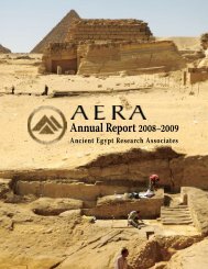
Figure 28. <strong>The</strong> northern enclosure wall of the <strong>KKT</strong>, completely<br />
scoured down to bedrock along the <strong>KKT</strong>-N on the west,<br />
continued to the east beyond the corner with the eastern<br />
enclosure wall and beyond a bedrock edge. <strong>The</strong> foundation of<br />
the wall extends as a bedrock projection and marl-plastered<br />
mudbrick. View to the west.<br />
sandy overburden 10.70 m farther south and found the<br />
continuation of the western mudbrick wall of the buried<br />
building (fig. 29).<br />
In 2008 Mark Lehner and Kasia Olchowska supervised<br />
the removal of the sandy overburden between the northern<br />
and southern 2007 trenches. A principal goal was to find<br />
how the lower building related to the eastern end of the<br />
<strong>Khentkawes</strong> causeway. As far as we knew from the 2007<br />
work, the causeway ends abruptly at the bedrock edge. In<br />
2007 we ascertained that the causeway, 1.72 m wide, is a<br />
later entrance at this edge, replacing an earlier entrance<br />
into a corridor, 2.38 m wide, with a door that fitted into<br />
a large limestone pivot socket on the north, and a large<br />
jamb on the south (fig. 30). In either phase, how did<br />
people ascend from the floor level of the lower building<br />
up over the bedrock face to this eastern threshold of the<br />
<strong>Khentkawes</strong> <strong>Town</strong><br />
In 2007 the area immediately east of the causeway<br />
threshold showed a mass of compact mud that banked<br />
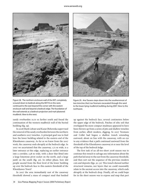
Figure 29. Ana Tavares steps down into the southernmost of<br />
two trenches that Lisa Yeomans excavated through the sand<br />
to the lower-lying mudbrick building during 2007. View to the<br />
northwest.<br />
up against the bedrock face, several centimeters below<br />
the upper edge of the bedrock. Patches of silty soil that<br />
overlapped the more compact mudmass appeared to have<br />
been thrown up from a series of pits and shallow trenches<br />
from earlier, albeit modern, digging. In 2007 Yeomans<br />
and Collet had begun a shallow trench extending<br />
eastward, about on line with the causeway, with an eye<br />
to any evidence that a path continued eastward from the<br />
threshold of the <strong>Khentkawes</strong> causeway at or near the level<br />
of the top of the bedrock ledge.<br />
<strong>The</strong> first task of an all-too-short 2008 season was to<br />
continue this trench to salvage any information about the<br />
path that led away to the east from the causeway threshold,<br />
and then sort out the sequence of the previous modern<br />
cuts and deposits (figs. 30–31). This trench showed neither<br />
structural remains, nor layers that we could reasonably<br />
relate to the ancient access into the causeway, which ends<br />
abruptly at the bedrock drop. Finally, all we could hope<br />
for in the short season was to expose and map that part<br />
34<br />
Giza Plateau Mapping Project Season 2008 Preliminary Report