The Khentkawes Town (KKT) - Ancient Egypt Research Associates
The Khentkawes Town (KKT) - Ancient Egypt Research Associates
The Khentkawes Town (KKT) - Ancient Egypt Research Associates

You also want an ePaper? Increase the reach of your titles
YUMPU automatically turns print PDFs into web optimized ePapers that Google loves.
www.aeraweb.org<br />
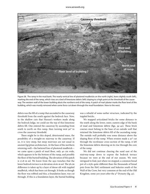
Causeway threshold<br />
Slope up<br />
West wall<br />
of building<br />
Floor level of building <br />
North end<br />
of ramp<br />
Figure 38. <strong>The</strong> ramp in the mud bank. <strong>The</strong> nearly vertical line of plastered mudbricks on the north (right), leans slightly south (left),<br />
marking the end of the ramp, which rises on a bed of limestone debris (left) sloping to a high point at the threshold of the causeway.<br />
<strong>The</strong> western wall of the lower building abuts the northern end of the ramp. A patch of marl plaster marks the floor level of the<br />
building, which was mostly removed when some force cut down through the mud foundation. View to the west.<br />
debris was the fill of a ramp that ascended to the causeway<br />
threshold from the south against the bedrock face. Now,<br />
in the shallow cuts that Hassan’s workers made along<br />
the bedrock ledge, we could see the top of this limestone<br />
debris fill. One entered the causeway by ascending from<br />
south to north on this ramp, then turning west 90° to<br />
cross the causeway threshold.<br />
<strong>The</strong>re might be in this sloped, deteriorated mass, the<br />
possibility of a straight-on stairway to the causeway. If<br />
so, it is very steep, but steep stairways are not usual in<br />
ancient <strong>Egypt</strong>ian architecture. At the base of the northern<br />
retaining wall—the battered line of plastered mudbrick—<br />
we came upon a patch of marl floor, only 40 cm wide,<br />
which appears to be the bottom of the ramp, and possibly<br />
the floor of the buried building. <strong>The</strong> elevation of this patch<br />
is 17.18 m asl. We know from the 1932 trenches that the<br />
lower bedrock terrace is at elevation 16.60 m asl. <strong>The</strong> 58 cm<br />
difference is taken up by a layer of dense silt with toppled<br />
mudbrick, which has been cut through. It looks as though<br />
the floor was robbed and this, a foundation layer, was cut<br />
through. If this is a foundation layer, the buried building<br />
was a rebuild of some earlier structure, indicated by the<br />
toppled bricks.<br />
We mapped articulated bricks for some distance to<br />
the south along the lower, outer, eastern edge of the bank<br />
of mud and limestone debris (figs. 39–40). <strong>The</strong>se brick<br />
courses must belong to the base of an outside wall that<br />
retained the limestone debris fill of the ascending ramp.<br />
<strong>The</strong> outside wall probably rose some distance above the<br />
sloping floor of the ramp. When erosion made a 30° cut<br />
through the rectilinear cross-section of the ramp, it left<br />
the limestone debris showing on its rise through the core<br />
of the ramp.<br />
We did not continue clearing the sand east of the<br />
stairway-ramp down to expose the bedrock terrace<br />
because we were at the end of our season. We were<br />
intrigued to find, just where we stopped, a common bread<br />
pot of a style quite different than the thousands of bread<br />
pots from the HeG settlement and bakeries south of the<br />
Wall of the Crow, but very common at the end of the Old<br />
Kingdom, some 300 years after the 4 th Dynasty (fig. 41).<br />
Giza Occasional Papers 4 41