

Download Guidebook as .pdf (1.8 Mb) - Carolina Geological Society
Download Guidebook as .pdf (1.8 Mb) - Carolina Geological Society
Download Guidebook as .pdf (1.8 Mb) - Carolina Geological Society

Create successful ePaper yourself
Turn your PDF publications into a flip-book with our unique Google optimized e-Paper software.
OUTCROPS IN THE VICINITY OF THE SAVANNAH RIVER SITE<br />
wall of the pit, suggesting exposure of the underlying upper<br />
Eocene Irwinton Member of the Dry Branch Formation. This<br />
yellow sand pinches out a short distance to the northwest and<br />
southe<strong>as</strong>t, however, and a red sand occurs beneath it. Evidence<br />
for the presence of the Irwinton at or near the b<strong>as</strong>e of<br />
the pit are tan clay exposed in places in the floor of the excavation<br />
and a pebble bed several tens of feet wide on the<br />
southwest wall of the pit, possibly the flat-pebble bed which<br />
marks the b<strong>as</strong>e of the Tobacco Road in places. Above this<br />
pebble bed, the sands are red, orange, and yellow; below,<br />
yellow sands are more conspicuous.<br />
The fairly clean, light colored sand several feet thick at<br />
the top is common in many places in the area. It may be<br />
leached soil horizon, but there h<strong>as</strong> been some discussion of<br />
eolian influence.<br />
The gray limestone which mimics an outcrop above the<br />
Tobacco Road on the northe<strong>as</strong>t wall of the pit appears to be<br />
composed of pieces of the middle Eocene “Blue Bluff” unit<br />
or member (Huddlestun and Hetrick, 1986, p.4). We have<br />
found boards in the bedded clay and sands above the limestone,<br />
and angular pebbles of metamorphic rock are mixed<br />
with the limestone.<br />
F. Roadcuts on the north loop of Good Hope Farms Road<br />
(county road 1956), off Silver Bluff Road (South <strong>Carolina</strong><br />
highway 302); about 4 mi south of the intersection of Silver<br />
Bluff Road and Pine Log Road (county road 87) southwest<br />
of Aiken, South <strong>Carolina</strong>.<br />
About 0.4 mi west of the intersection of Good Hope<br />
Farms Road and Silver Bluff Road, the extremely poorly<br />
sorted, cobbly facies of the Miocene Altamaha Formation is<br />
exposed. Rounded quartz cobbles and pebbles are in a matrix<br />
of and interbedded with red clayey sand with weathered feldspar<br />
grains.<br />
Down the road (to the west), cuts expose red and orange,<br />
clayey, silty, poorly sorted medium and coarse sand of the<br />
upper Eocene Tobacco Road Sand. Cross-beds, clay-filled<br />
fissures, burrows, and white clay cl<strong>as</strong>ts occur in places. The<br />
sand overlies bedded tan clays typical of the upper Eocene<br />
Dry Branch Formation and a m<strong>as</strong>sive, tan, light gray, and<br />
pink clay which may be the top of the “Huber Formation”.<br />
About 0.9 mi west of the intersection of Good Hope Farms<br />
Road and Silver Bluff Road is an outcrop of well-sorted,<br />
very fine and fine, burrowed sand with clay laminae (see figure).<br />
In cores and outcrops at SRS, fine and very vine sands<br />
with clay laminae and burrows in places are common in the<br />
middle Eocene Tinker Creek Formation, interbedded with<br />
and updip from the middle Eocene Santee Limestone. These<br />
fine sands overlie the Congaree and Warley Hill formations.<br />
The fine, well-sorted sand in this outcrop is thought to be the<br />
Tinker Creek.<br />
The iron oxide-rich quartz pebble conglomerate and<br />
coarse sand above the Tinker Creek sand appears to be the<br />
same unit <strong>as</strong> the coarser sand to the e<strong>as</strong>t and up the road<br />
<strong>as</strong>signed to the Tobacco Road. If it is, the Dry Branch Formation<br />
is missing at this outcrop. Another possibility is that<br />
the coarse nit is a facies of the Oligocene (to Miocene)<br />
channels described by Zullo and others (1982) and Willoughby<br />
and others (1984).<br />
H. Outcrop on north side of Hitchcock Parkway (South<br />
<strong>Carolina</strong> Highway 478) on the south side of Aiken, South<br />
<strong>Carolina</strong>, about 0.8 mi west of the intersection of Hitchcock<br />
and Pine Log Road (county road 87).<br />
Light gray to tan, silicified, pebbly, coarse sandstone<br />
with prominent burrows crops out on the hillside. Light gray,<br />
yellowish and tan clay lies beneath the sand. Silicified shell<br />
fragments that appear to be Cr<strong>as</strong>sostrea gigantissima occur<br />
here. This may be the upper Eocene Dry Branch Formation,<br />
similar to facies described by Nystrom and others (1986, p.<br />
17). It could also be a facies of the Oligocene (to Miocene)<br />
channels described by Zullo and others (1982) and Willoughby<br />
and others (1984).<br />
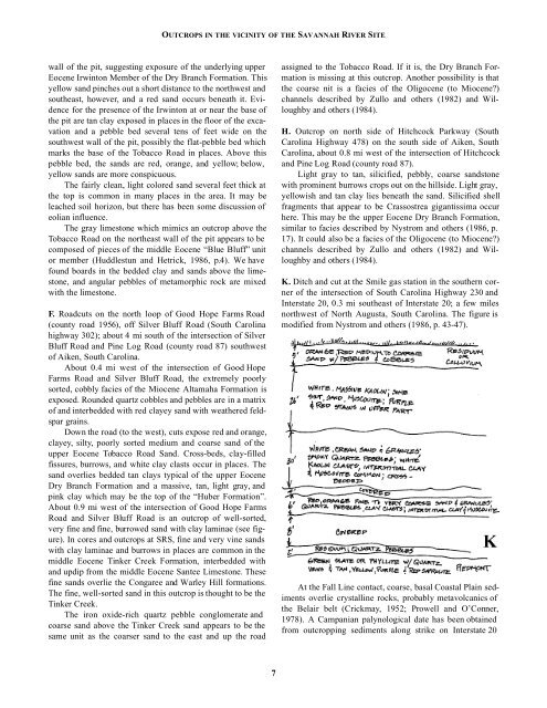
K. Ditch and cut at the Smile g<strong>as</strong> station in the southern corner<br />
of the intersection of South <strong>Carolina</strong> Highway 230 and<br />
Interstate 20, 0.3 mi southe<strong>as</strong>t of Interstate 20; a few miles<br />
northwest of North Augusta, South <strong>Carolina</strong>. The figure is<br />
modified from Nystrom and others (1986, p. 43-47).<br />
At the Fall Line contact, coarse, b<strong>as</strong>al Co<strong>as</strong>tal Plain sediments<br />
overlie crystalline rocks, probably metavolcanics of<br />
the Belair belt (Crickmay, 1952; Prowell and O’Conner,<br />
1978). A Campanian palynological date h<strong>as</strong> been obtained<br />
from outcropping sediments along strike on Interstate 20<br />
7


