

Download Guidebook as .pdf (1.8 Mb) - Carolina Geological Society
Download Guidebook as .pdf (1.8 Mb) - Carolina Geological Society
Download Guidebook as .pdf (1.8 Mb) - Carolina Geological Society

Create successful ePaper yourself
Turn your PDF publications into a flip-book with our unique Google optimized e-Paper software.
OUTCROPS IN THE VICINITY OF THE SAVANNAH RIVER SITE<br />
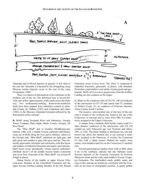
Altamaha and of fluvial deposits in general. A few miles to<br />
the e<strong>as</strong>t, the Altamaha is truncated by the Orangeburg scarp.<br />
Pliocene marine deposits occur to the e<strong>as</strong>t of the scarp<br />
(Colquhoun, 1988).<br />
There is evidence of deformation in the sediments at the<br />
northern end of the cut. The deformed zone is several feet<br />
wide and strikes approximately north-south across the highway.<br />
Two northe<strong>as</strong>terly-striking, down-to-the-northwest<br />
faults have been mapped from subsurface control in Allendale<br />
County by Oldham (1981) and Colquhoun and others<br />
(1983). Is the Miocene Altamaha Formation affected by the<br />
deformation at this outcrop<br />
B. Bluffs along Savannah River and tributaries, Georgia<br />
Power Company Plant Vogtle, Burke County, Georgia, off<br />
River Road.<br />
The “Blue Bluff” unit or member (Huddlestun and<br />
Hetrick, 1986, p.4), a middle Eocene carbonate cliff-former,<br />
crops out in bluffs along the river and in tributary valleys on<br />
the Georgia side. “Blue Bluff” sediments are light gray, and<br />
pale green and weather to gray, olive gray, and tan. They are<br />
mostly glauconitic calcilutite and calcarenite with thin layers<br />
and nodules of indurated limestone and quartz sand laminae.<br />
Shell layers occur sporadically. Cream colored carbonates<br />
(McBean facies”) of the middle Eocene Santee Limestone<br />
also occur here. Outcrops of the “Blue Bluff” are at le<strong>as</strong>t 40<br />
ft high in places.<br />
Slump blocks of the middle or upper Eocene Utley<br />
Limestone Member of the Clinchfield Formation and the<br />
upper Eocene Griffins Landing Member of the Dry Branch<br />
Formation occur at river level. The Utley is composed of<br />
indurated limestone, glauconitic in places, with abundant<br />
Periarchus (sand dollars) and molds of pelecypods and g<strong>as</strong>tropods.<br />
Shells of Cr<strong>as</strong>sostrea gigantissima from the Griffins<br />
Landing are also common on the slopes.<br />
C. Bank on the southwest side of US 278, 100 yd southe<strong>as</strong>t<br />
of the intersection of US 178 and county road 57; southe<strong>as</strong>t<br />
of Hollow Creek, 0.3 mi southe<strong>as</strong>t of Petticoat Junction,<br />
Aiken County, South <strong>Carolina</strong>.<br />
The m<strong>as</strong>sive, color-mottled clay at the b<strong>as</strong>e of the outcrop<br />
is similar to the oxidized clay found at the top of the<br />
Cretaceous in outcrops and in cores from SRS. It is tentatively<br />
<strong>as</strong>signed to the Upper Cretaceous.<br />
A sample from a roadside ditch beside county road 57 a<br />
short distance southwest of the intersection with US 278<br />
yielded an early Paleocene age (see Nystrom and others,<br />
1991, p. 224). The thinly bedded or laminated, tan, red, and<br />
brown clay above the mottled clay at our outcrop is tentatively<br />
<strong>as</strong>signed to the Paleocene. It overlies the Cretaceous<br />
() clay with a sharp contact. Behind the nearby store,<br />
coarse, cross-bedded sand lies on the Cretaceous () mottled<br />
clay.<br />
Several palynological samples from wells at SRS, about<br />
4 mi to the southe<strong>as</strong>t, indicate that late Sabinian (early<br />
Eocene) deposits of the Fourmile Formation lie between<br />
Paleocene strata and the early (and middle) Eocene Congaree<br />
Formation. The interbedded sands, pebbly sands, and<br />
clays at this outcrop are tentatively correlated with the Fourmile<br />
on the b<strong>as</strong>is of stratigraphic position. A quartz pebble<br />
5


