

Download Guidebook as .pdf (1.8 Mb) - Carolina Geological Society
Download Guidebook as .pdf (1.8 Mb) - Carolina Geological Society
Download Guidebook as .pdf (1.8 Mb) - Carolina Geological Society

Create successful ePaper yourself
Turn your PDF publications into a flip-book with our unique Google optimized e-Paper software.
CAROLINA GEOLOGICAL SOCIETY<br />
<strong>Guidebook</strong> for 1992 Annual Meeting<br />
Pages 67-70<br />
MIDDLE AND LATE WISCONSINAN RADIOCARBON DATES OF PEAT IN UPPER THREE RUNS AND<br />
TINKER CREEK ALLUVIAL SEDIMENTS: CONSTRAINTS ON RATES OF INCISION AND SEDIMENTATION<br />
Paul G. Nystrom, Jr.<br />
South <strong>Carolina</strong> <strong>Geological</strong> Survey<br />
INTRODUCTION<br />
The Savannah River Site is located between the Cape<br />
Fear Arch and the southe<strong>as</strong>t Georgia Embayment, two features<br />
which have affected sedimentary patterns in the Carolin<strong>as</strong><br />
and Georgia since the Cretaceous. Evidence for<br />
continuing tectonic adjustment in the region from the Late<br />
Cretaceous through the Holocene includes the warping of<br />
units, faulting, and earthquake-induced structures (Prowell<br />
and Obermeier, 1991). The incised topography of the SRS<br />
and surrounding area certainly suggests epierogenic uplift<br />
played a role in sculpturing the landscape.<br />
In the late middle to early late Miocene uplift in the<br />
Blue Ridge and western Piedmont caused the fluvial deposition<br />
of the upland unit/Altamaha Formation which covered<br />
the Upper Co<strong>as</strong>tal Plain from northe<strong>as</strong>t of the Wateree River<br />
in South <strong>Carolina</strong> to south of the Occmulgee River in Georgia<br />
(Nystrom and others, 1986, Nystrom and Willoughby,<br />
1992). As the cobble facies of the upland unit delineates the<br />
ancestral Savannah River (Nystrom, 1990), the evolution of<br />
the Savannah River valley began during deposition of the<br />
upland unit and h<strong>as</strong> continued until today. The detailed<br />
investigation of surficial deposits in the Augusta area by<br />
Newell and others (1980) showed the development of the<br />
landscape began in the Miocene and that uplift h<strong>as</strong> been the<br />
major influence in shaping the topography. The higher elevations,<br />
greater relief and greater drainage density which characterize<br />
the erosional topography of the Upper Co<strong>as</strong>tal Plain,<br />
compared with the more subdued, predominantly depositional<br />
topography on the middle Pliocene Duplin Formation<br />
below the Orangeburg Scarp (Dowsett and Cronin, 1990),<br />
indicates that most of the uplift and incision occurred before<br />
the middle Pliocene (Coloquhoun, 1981).<br />
Yet, the geomorphology of the Upper Co<strong>as</strong>tal Plain cannot<br />
be properly interpreted without a full appreciation of the<br />
diverse effects of the geologic and climatic changes during<br />
the Plio-Pleistocene. The rise and fall of sea level and thus<br />
river b<strong>as</strong>e level, and the severe climatic fluctuations were<br />
important controls on landscape development.<br />
In the Upper Co<strong>as</strong>tal Plain the Savannah River h<strong>as</strong><br />
incised the uplands and migrated to the southwest leaving<br />
unpaired fluvial terraces to the northe<strong>as</strong>t of the river. Today<br />
the broad, flat floodplains of the Savannah, Upper Three<br />
Runs and Tinker Creek suggest the more recent history of the<br />
river and its major tributaries h<strong>as</strong> been characterized by sedimentation<br />
more than erosion. The floodplain and alluvial terrace<br />
deposits can tell us much about the Quaternary history<br />
of the area.<br />
It is the purpose of this short paper to present preliminary<br />
information on the stratigraphic setting and radiocarbon<br />
ages of peat deposits in alluvial sediments of Upper Three<br />
Runs and Tinker Creek in the northern part of the SRS. The<br />
dates should place some constraints on rates of incision and<br />
sedimentation in those streams. In addition, <strong>as</strong> more peat<br />
deposits are dated those dates will allow comparison<br />
between the alluvial record and independent b<strong>as</strong>e level, climatic,<br />
and tectonic records to better determine the relative<br />
influence of those controls<br />
METHODS<br />
During the summer of 1990, using a truck-mounted drill<br />
rig, a series of holes w<strong>as</strong> drilled across Upper Three Runs<br />
valley, then another series w<strong>as</strong> drilled across part of Tinker<br />
Creek Valley (figures 1,2,and 3). Cross-section A-A’ and B-<br />
B” were constructed from 1:24,000 scale topographic maps<br />
and the drill hole logs. Each hole w<strong>as</strong> drilled using the power<br />
auger technique of penetrating 10 feet, then pulling the auger<br />
out and making a detailed lithologic log of the sediments on<br />
the auger flanges. That procedure w<strong>as</strong> repeated in 10 foot<br />
intervals until the target depth w<strong>as</strong> reached. The average<br />
depth of the holes w<strong>as</strong> approximately 60 feet. A sharp lithologic<br />
change marked the b<strong>as</strong>e of the alluvial section in each<br />
hole. All of the peat deposits intersected were described and<br />
sampled. The peat samples were split, and Kathryn Hanson<br />
and Tom Bullard of Geomatrix Consultants had radiocarbon<br />
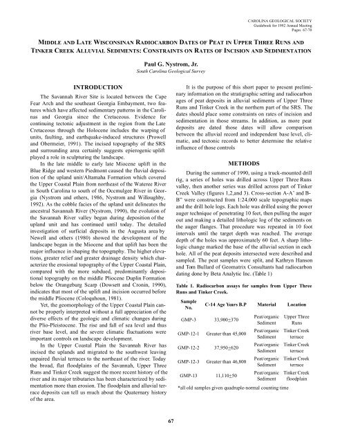
dating done by Beta Analytic Inc. (Table 1)<br />
.<br />
Table 1. Radiocarbon <strong>as</strong>says for samples from Upper Three<br />
Runs and Tinker Creek.<br />
Sample<br />
No.<br />
C-14 Age Years B.P Material Location<br />
GMP-3 33,900+370<br />
GMP-12-1 Greater than 45,000<br />
GMP-12-2 37,950+620<br />
GMP-12-3 Greater than 46,800<br />
GMP-13 11,110+50<br />
Peat/organic<br />
Sediment<br />
Peat/organic<br />
Sediment<br />
Peat/organic<br />
Sediment<br />
Peat/organic<br />
Sediment<br />
Peat/organic<br />
Sediment<br />
*all old samples given quadruple-normal counting time<br />
Upper Three<br />
Runs<br />
Tinker Creek<br />
terrace<br />
Tinker Creek<br />
terrace<br />
Tinker Creek<br />
terrace<br />
Tinker Creek<br />
floodplain<br />
67


