

Download Guidebook as .pdf (1.8 Mb) - Carolina Geological Society
Download Guidebook as .pdf (1.8 Mb) - Carolina Geological Society
Download Guidebook as .pdf (1.8 Mb) - Carolina Geological Society

You also want an ePaper? Increase the reach of your titles
YUMPU automatically turns print PDFs into web optimized ePapers that Google loves.
CAROLINA GEOLOGICAL SOCIETY<br />
<strong>Guidebook</strong> for 1992 Annual Meeting<br />
Pages 71-76<br />
HYDROSTRATIGRAPHY OF THE SAVANNAH RIVER SITE REGION, SOUTH CAROLINA AND GEORGIA<br />
Rolf K. Aadland 1 , Paul A. Thaye 2 , and Andrew D. Smits 3<br />
1 Environmental Sciences Section, SRTC, Westinghouse Savannah River Co., P.O. Box 616, Aiken South <strong>Carolina</strong> 29802<br />
2 Department of Earth Sciences, UNCW, 601 South College Road, Wilmington, NC 28403-3297<br />
3 Science Applications International Corporation, 360 Bay Street, Suite 200, Augusta, GA 30901<br />
INTRODUCTION<br />
Numerous studies have described and modeled the<br />
hydrostratigraphy in and around the Savannah River Site<br />
(SRS) area (Siple, 1967; Colquhoun and others, 1983;<br />
Brooks and others, 1985; Clarke and others, 1985; Miller,<br />
1986; Aucott and others 1987; Aucott, 1988; Krause and<br />
Randolph, 1989). Central to all previous studies is the one to<br />
one correspondence between hydrostratigraphic units and<br />
lithostratigraphic units. This method is difficult to apply<br />
regionally owing to the abrupt facies changes in stratigraphic<br />
units of the updip Co<strong>as</strong>tal Plain sequence. For example,<br />
lithostratigraphic units included in aquifer and confining<br />
units at one location are often not present or are of different<br />
hydraulic character elsewhere.<br />
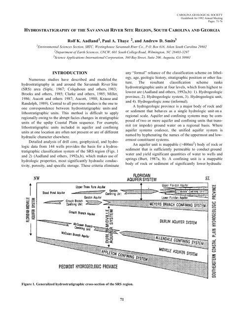
Detailed analysis of drill core, geophysical, and hydrologic<br />
data from 144 wells provides the b<strong>as</strong>is for a hydrostratigraphic<br />
cl<strong>as</strong>sification system of the SRS region (Figs. 1<br />
and 2) (Aadland and others, 1992a,b), which makes use of<br />
hydrologic properties, most significantly hydraulic conductivity,<br />
porosity, and specific storage. These criteria eliminate<br />
any “formal” reliance of the cl<strong>as</strong>sification scheme on lithology,<br />
age, geologic history, stratigraphic position or other feature.<br />
The resultant cl<strong>as</strong>sification scheme ranks<br />
hydrostratigraphic units at four levels, which from highest to<br />
lowest are (Aadland and others, 1992a,b): 1). Hydrogeologic<br />
province, 2). Hydrogeologic system, 3). Hydrogeologic unit,<br />
and 4). Hydrogeologic zone (informal).<br />
A hydrogeologic province is a major body of rock and/<br />
or sediment that behaves <strong>as</strong> a single hydrologic unit on a<br />
regional scale. Aquifer and confining systems may be composed<br />
of two or more aquifer and confining units that transmit<br />
(or impede) ground water on a regional b<strong>as</strong>is. Where<br />
aquifer systems coalesce, the unified aquifer system is<br />
named by hyphenating the names of the uppermost and lowermost<br />
constituent systems.<br />
An aquifer unit is mappable (>400mi 2 ) body of rock or<br />
sediment that is sufficiently permeable to conduct ground<br />
water and yield significant quantities of water to wells and<br />
springs (Burt, 1987a, b). A confining unit is a mappable<br />
body of rock or sediment of significantly lower hydraulic<br />
Figure 1. Generalized hydrostratigraphic cross-section of the SRS region.<br />
71


