

Download Guidebook as .pdf (1.8 Mb) - Carolina Geological Society
Download Guidebook as .pdf (1.8 Mb) - Carolina Geological Society
Download Guidebook as .pdf (1.8 Mb) - Carolina Geological Society

You also want an ePaper? Increase the reach of your titles
YUMPU automatically turns print PDFs into web optimized ePapers that Google loves.
HYDROSTRATIGRAPHY OF THE SAVANNAH RIVER SITE REGION<br />
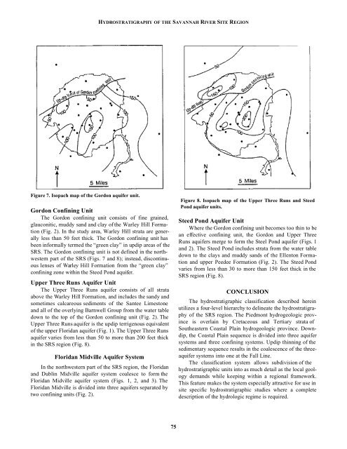
Figure 7. Isopach map of the Gordon aquifer unit.<br />
Gordon Confining Unit<br />
The Gordon confining unit consists of fine grained,<br />
glauconitic, muddy sand and clay of the Warley Hill Formation<br />
(Fig. 2). In the study area, Warley Hill strata are generally<br />
less than 50 feet thick. The Gordon confining unit h<strong>as</strong><br />
been informally termed the “green clay” in updip are<strong>as</strong> of the<br />
SRS. The Gordon confining unit is not defined in the northwestern<br />
part of the SRS (Figs. 7 and 8); instead, discontinuous<br />
lenses of Warley Hill Formation from the “green clay”<br />
confining zone within the Steed Pond aquifer.<br />
Upper Three Runs Aquifer Unit<br />
The Upper Three Runs aquifer consists of all strata<br />
above the Warley Hill Formation, and includes the sandy and<br />
sometimes calcareous sediments of the Santee Limestone<br />
and all of the overlying Barnwell Group from the water table<br />
down to the top of the Gordon confining unit (Fig. 2). The<br />
Upper Three Runs aquifer is the updip terrigenous equivalent<br />
of the upper Floridan aquifer (Fig. 1). The Upper Three Runs<br />
aquifer varies from less than 50 to more than 200 feet thick<br />
in the SRS region (Fig. 8).<br />
Floridan Midville Aquifer System<br />
In the northwestern part of the SRS region, the Floridan<br />
and Dublin Midville aquifer system coalesce to form the<br />
Floridan Midville aquifer system (Figs. 1, 2, and 3). The<br />
Floridan Midville is divided into three aquifers separated by<br />
two confining units (Fig. 2).<br />
Figure 8. Isopach map of the Upper Three Runs and Steed<br />
Pond aquifer units.<br />
Steed Pond Aquifer Unit<br />
Where the Gordon confining unit becomes too thin to be<br />
an effective confining unit, the Gordon and Upper Three<br />
Runs aquifers merge to form the Steel Pond aquifer (Figs. 1<br />
and 2). The Steed Pond includes strata from the water table<br />
down to the clays and muddy sands of the Ellenton Formation<br />
and upper Peedee Formation (Fig. 2). The Steed Pond<br />
varies from less than 30 to more than 150 feet thick in the<br />
SRS region (Fig. 8).<br />
CONCLUSION<br />
The hydrostratigraphic cl<strong>as</strong>sification described herein<br />
utilizes a four-level hierarchy to delineate the hydrostratigraphy<br />
of the SRS region. The Piedmont hydrogeologic province<br />
is overlain by Cretaceous and Tertiary strata of<br />
Southe<strong>as</strong>tern Co<strong>as</strong>tal Plain hydrogeologic province. Downdip,<br />
the Co<strong>as</strong>tal Plain sequence is divided into three aquifer<br />
systems and three confining systems. Updip thinning of the<br />
sedimentary sequence results in the coalescence of the threeaquifer<br />
systems into one at the Fall Line.<br />
The cl<strong>as</strong>sification system allows subdivision of the<br />
hydrostratigraphic units into <strong>as</strong> much detail <strong>as</strong> the local geology<br />
demands while keeping within a regional framework.<br />
This feature makes the system especially attractive for use in<br />
site specific hydrostratigraphic studies where a complete<br />
description of the hydrologic regime is required.<br />
75


