

Download Guidebook as .pdf (1.8 Mb) - Carolina Geological Society
Download Guidebook as .pdf (1.8 Mb) - Carolina Geological Society
Download Guidebook as .pdf (1.8 Mb) - Carolina Geological Society

Create successful ePaper yourself
Turn your PDF publications into a flip-book with our unique Google optimized e-Paper software.
HYDROSTRATIGRAPHY OF THE SAVANNAH RIVER SITE REGION<br />
SRS region.<br />
The strata that form the three aquifer systems consist of<br />
fine to coarse grained sand, with local gravelly zones, deposited<br />
under relatively high energy conditions in fluvial to shallow<br />
marine environments. Marine limestone is locally<br />
intercalated with the sands. Generally, the fine grained sediments<br />
that comprise the regional confining systems were<br />
deposited in low energy marine and fluvial environments.<br />
Locally the confining system contain beds of sand or other<br />
high permeability materials, but overall, the units retard vertical<br />
flow between the overlying and underlying aquifer systems.<br />
attains a thickness greater than 300 feet (Fig. 5), and consists<br />
of sand and muddy sand of the Middendorf and lower part of<br />
the Black Creek Formation (Fig. 2). The extent of the Midville<br />
aquifer system is defined by the updip limit of the overlying<br />
Allendale confining system (Fig. 3); northwest of the<br />
updip terminus, the Midville aquifer is termed the McQueen<br />
Branch aquifer of the Dublin-Midville and Floridan-Midville<br />
aquifer systems (Figs. 1 and 2).<br />
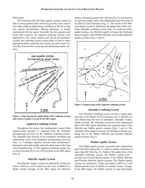
Figure 4. Isopach map of the Appleton confining system.<br />
Figure 3. Map showing the updip limits of the confining systems<br />
and extent of aquifer systems in the SRS region.<br />
Appleton Confining System<br />
Throughout the region, the Southe<strong>as</strong>tern Co<strong>as</strong>tal Plain<br />
hydrogeologic province is separated from the Piedmont<br />
hydrogeologic province by the Appleton confining system.<br />
The Appleton rests directly on un-weathered crystalline and<br />
sedimentary rocks of the Piedmont hydrogeologic province<br />
(Fig. 1); it includes saprolite derived from weathering of<br />
b<strong>as</strong>ement rocks, and muddy sand and sandy mud of the Cape<br />
Fear Formation (Fig. 2). The Appleton confining system varies<br />
from less than 50 to over 250 feet thick in the SRS region<br />
(Fig. 4).<br />
Midville Aquifer System<br />
The Midville Aquifer system w<strong>as</strong> defined by Clarke and<br />
others (1985) in a well located near the town of Midville in<br />
Burke County, Georgia. In the SRS region, the Midville<br />
Allendale Confining System<br />
The Allendale confining system consists of sandy mud<br />
and clay of the Black Creek Formation and is defined in a<br />
well drilled near the town of Allendale, Allendale County,<br />
South <strong>Carolina</strong>. The Allendale is present in the southe<strong>as</strong>tern<br />
half of the SRS region and defines the regional extent of the<br />
Midville and Dublin aquifer systems (Figs. 1 and 3). The<br />
Allendale thins updip to become the McQueen Branch confining<br />
unit of the Dublin Midville and Floridan Midville<br />
aquifer systems (Fig.1).<br />
Dublin Aquifer System<br />
The Dublin aquifer system is present in the southe<strong>as</strong>tern<br />
half of the SRS region (Fig. 3), where it attains a thickness of<br />
more than 300 feet (Fig. 6). North of the updip limit of the<br />
Allendale confining system, the Dublin aquifer syste<br />
becomes the Crouch Branch aquifer of the Dublin Midville<br />
and Floridan Midville aquifer systems. The Dublin aquifer<br />
system w<strong>as</strong> defined by Clarke and others (1985) in a well<br />
drilled near the town of Dublin in Laurens County, Georgia.<br />
In the SRS region, the Dublin consists of sand and muddy<br />
73


