Natural Resource Inventory and Assessment - Town of Guilford
Natural Resource Inventory and Assessment - Town of Guilford
Natural Resource Inventory and Assessment - Town of Guilford

Create successful ePaper yourself
Turn your PDF publications into a flip-book with our unique Google optimized e-Paper software.
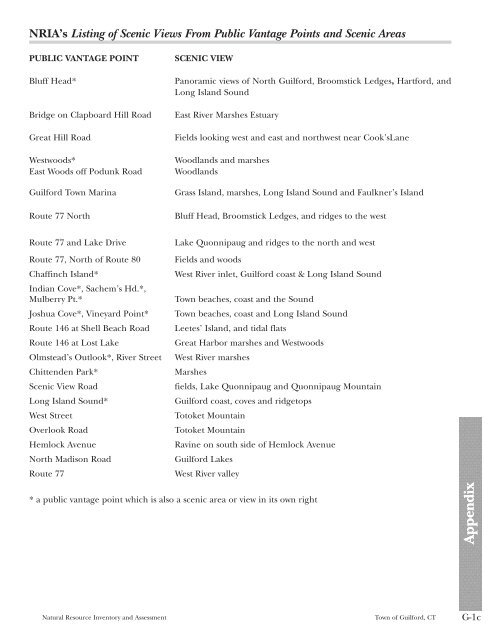
NRIA’s Listing <strong>of</strong> Scenic Views From Public Vantage Points <strong>and</strong> Scenic Areas<br />
PUBLIC VANTAGE POINT SCENIC VIEW<br />
Bluff Head* Panoramic views <strong>of</strong> North <strong>Guilford</strong>, Broomstick Ledges, Hartford, <strong>and</strong><br />
Long Isl<strong>and</strong> Sound<br />
Bridge on Clapboard Hill Road East River Marshes Estuary<br />
Great Hill Road Fields looking west <strong>and</strong> east <strong>and</strong> northwest near Cook’sLane<br />
Westwoods* Woodl<strong>and</strong>s <strong>and</strong> marshes<br />
East Woods <strong>of</strong>f Podunk Road Woodl<strong>and</strong>s<br />
<strong>Guilford</strong> <strong>Town</strong> Marina Grass Isl<strong>and</strong>, marshes, Long Isl<strong>and</strong> Sound <strong>and</strong> Faulkner’s Isl<strong>and</strong><br />
Route 77 North Bluff Head, Broomstick Ledges, <strong>and</strong> ridges to the west<br />
Route 77 <strong>and</strong> Lake Drive Lake Quonnipaug <strong>and</strong> ridges to the north <strong>and</strong> west<br />
Route 77, North <strong>of</strong> Route 80 Fields <strong>and</strong> woods<br />
Chaffinch Isl<strong>and</strong>*<br />
Indian Cove*, Sachem’s Hd.*,<br />
West River inlet, <strong>Guilford</strong> coast & Long Isl<strong>and</strong> Sound<br />
Mulberry Pt.* <strong>Town</strong> beaches, coast <strong>and</strong> the Sound<br />
Joshua Cove*, Vineyard Point* <strong>Town</strong> beaches, coast <strong>and</strong> Long Isl<strong>and</strong> Sound<br />
Route 146 at Shell Beach Road Leetes’ Isl<strong>and</strong>, <strong>and</strong> tidal flats<br />
Route 146 at Lost Lake Great Harbor marshes <strong>and</strong> Westwoods<br />
Olmstead’s Outlook*, River Street West River marshes<br />
Chittenden Park* Marshes<br />
Scenic View Road fields, Lake Quonnipaug <strong>and</strong> Quonnipaug Mountain<br />
Long Isl<strong>and</strong> Sound* <strong>Guilford</strong> coast, coves <strong>and</strong> ridgetops<br />
West Street Totoket Mountain<br />
Overlook Road Totoket Mountain<br />
Hemlock Avenue Ravine on south side <strong>of</strong> Hemlock Avenue<br />
North Madison Road <strong>Guilford</strong> Lakes<br />
Route 77 West River valley<br />
* a public vantage point which is also a scenic area or view in its own right<br />
<strong>Natural</strong> <strong>Resource</strong> <strong>Inventory</strong> <strong>and</strong> <strong>Assessment</strong> <strong>Town</strong> <strong>of</strong> <strong>Guilford</strong>, CT G-1c<br />
Appendix Appendix