Natural Resource Inventory and Assessment - Town of Guilford
Natural Resource Inventory and Assessment - Town of Guilford
Natural Resource Inventory and Assessment - Town of Guilford

You also want an ePaper? Increase the reach of your titles
YUMPU automatically turns print PDFs into web optimized ePapers that Google loves.
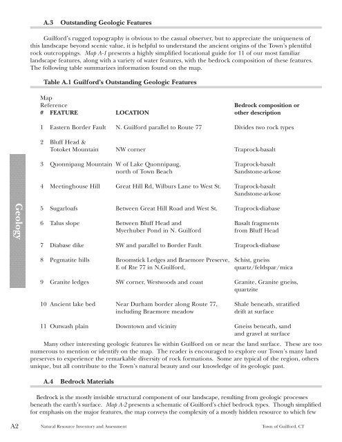
Geology<br />
A2<br />
A.3 Outst<strong>and</strong>ing Geologic Features<br />
<strong>Guilford</strong>’s rugged topography is obvious to the casual observer, but to appreciate the uniqueness <strong>of</strong><br />
this l<strong>and</strong>scape beyond scenic value, it is helpful to underst<strong>and</strong> the ancient origins <strong>of</strong> the <strong>Town</strong>’s plentiful<br />
rock outcroppings. Map A-1 presents a highly simplified locational guide for 11 <strong>of</strong> our most familiar<br />
l<strong>and</strong>scape features, along with a variety <strong>of</strong> water features, with the bedrock composition <strong>of</strong> these features.<br />
The following table summarizes information found on the map.<br />
Table A.1 <strong>Guilford</strong>’s Outst<strong>and</strong>ing Geologic Features<br />
Map<br />
Reference Bedrock composition or<br />
# FEATURE LOCATION other description<br />
1 Eastern Border Fault N. <strong>Guilford</strong> parallel to Route 77 Divides two rock types<br />
2 Bluff Head &<br />
Totoket Mountain NW corner Traprock-basalt<br />
3 Quonnipaug Mountain W <strong>of</strong> Lake Quonnipaug, Traprock-basalt<br />
north <strong>of</strong> <strong>Town</strong> Beach S<strong>and</strong>stone-arkose<br />
4 Meetinghouse Hill Great Hill Rd, Wilburs Lane to West St. Traprock-basalt<br />
S<strong>and</strong>stone-arkose<br />
5 Sugarloafs Between Great Hill Road <strong>and</strong> West St. Traprock-diabase<br />
6 Talus slope Between Bluff Head <strong>and</strong> Basalt fragments<br />
Myerhuber Pond in N. <strong>Guilford</strong> from Bluff Head<br />
7 Diabase dike SW <strong>and</strong> parallel to Border Fault Traprock-diabase<br />
8 Pegmatite hills Broomstick Ledges <strong>and</strong> Braemore Preserve, Schist, gneiss<br />
E <strong>of</strong> Rte 77 in N.<strong>Guilford</strong>, quartz/feldspar/mica<br />
9 Granite ledges SW corner, Westwoods <strong>and</strong> coast Granite, Granite gneiss,<br />
quartzite<br />
10 Ancient lake bed Near Durham border along Route 77, Shale beneath, stratified<br />
including Braemore meadow drift at surface<br />
11 Outwash plain Downtown <strong>and</strong> vicinity Gneiss beneath, s<strong>and</strong><br />
<strong>and</strong> gravel at surface<br />
Many other interesting geologic features lie within <strong>Guilford</strong> on or near the l<strong>and</strong> surface. These are too<br />
numerous to mention or identify on the map. The reader is encouraged to explore our <strong>Town</strong>’s many l<strong>and</strong><br />
preserves to experience the remarkable diversity <strong>of</strong> rock formations. Some are typical <strong>of</strong> the region, others<br />
unique, but all contribute to the <strong>Town</strong>’s natural beauty <strong>and</strong> our knowledge <strong>of</strong> its geologic past.<br />
A.4 Bedrock Materials<br />
Bedrock is the mostly invisible structural component <strong>of</strong> our l<strong>and</strong>scape, resulting from geologic processes<br />
beneath the earth’s surface. Map A-2 presents a schematic <strong>of</strong> <strong>Guilford</strong>’s chief bedrock types. Though simplified<br />
for emphasis on the major features, the map conveys the complexity <strong>of</strong> a mostly hidden resource to which few<br />
<strong>Natural</strong> <strong>Resource</strong> <strong>Inventory</strong> <strong>and</strong> <strong>Assessment</strong> <strong>Town</strong> <strong>of</strong> <strong>Guilford</strong>, CT