Natural Resource Inventory and Assessment - Town of Guilford
Natural Resource Inventory and Assessment - Town of Guilford
Natural Resource Inventory and Assessment - Town of Guilford

Create successful ePaper yourself
Turn your PDF publications into a flip-book with our unique Google optimized e-Paper software.
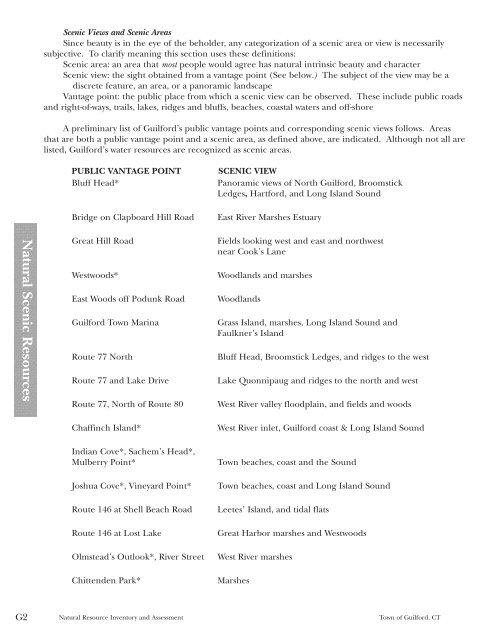
<strong>Natural</strong> Scenic <strong>Resource</strong>s<br />
G2<br />
Scenic Views <strong>and</strong> Scenic Areas<br />
Since beauty is in the eye <strong>of</strong> the beholder, any categorization <strong>of</strong> a scenic area or view is necessarily<br />
subjective. To clarify meaning this section uses these definitions:<br />
Scenic area: an area that most people would agree has natural intrinsic beauty <strong>and</strong> character<br />
Scenic view: the sight obtained from a vantage point (See below.) The subject <strong>of</strong> the view may be a<br />
discrete feature, an area, or a panoramic l<strong>and</strong>scape<br />
Vantage point: the public place from which a scenic view can be observed. These include public roads<br />
<strong>and</strong> right-<strong>of</strong>-ways, trails, lakes, ridges <strong>and</strong> bluffs, beaches, coastal waters <strong>and</strong> <strong>of</strong>f-shore<br />
A preliminary list <strong>of</strong> <strong>Guilford</strong>’s public vantage points <strong>and</strong> corresponding scenic views follows. Areas<br />
that are both a public vantage point <strong>and</strong> a scenic area, as defined above, are indicated. Although not all are<br />
listed, <strong>Guilford</strong>’s water resources are recognized as scenic areas.<br />
PUBLIC VANTAGE POINT SCENIC VIEW<br />
Bluff Head* Panoramic views <strong>of</strong> North <strong>Guilford</strong>, Broomstick<br />
Ledges, Hartford, <strong>and</strong> Long Isl<strong>and</strong> Sound<br />
Bridge on Clapboard Hill Road East River Marshes Estuary<br />
Great Hill Road Fields looking west <strong>and</strong> east <strong>and</strong> northwest<br />
near Cook’s Lane<br />
Westwoods* Woodl<strong>and</strong>s <strong>and</strong> marshes<br />
East Woods <strong>of</strong>f Podunk Road Woodl<strong>and</strong>s<br />
<strong>Guilford</strong> <strong>Town</strong> Marina Grass Isl<strong>and</strong>, marshes, Long Isl<strong>and</strong> Sound <strong>and</strong><br />
Faulkner’s Isl<strong>and</strong><br />
Route 77 North Bluff Head, Broomstick Ledges, <strong>and</strong> ridges to the west<br />
Route 77 <strong>and</strong> Lake Drive Lake Quonnipaug <strong>and</strong> ridges to the north <strong>and</strong> west<br />
Route 77, North <strong>of</strong> Route 80 West River valley floodplain, <strong>and</strong> fields <strong>and</strong> woods<br />
Chaffinch Isl<strong>and</strong>* West River inlet, <strong>Guilford</strong> coast & Long Isl<strong>and</strong> Sound<br />
Indian Cove*, Sachem’s Head*,<br />
Mulberry Point* <strong>Town</strong> beaches, coast <strong>and</strong> the Sound<br />
Joshua Cove*, Vineyard Point* <strong>Town</strong> beaches, coast <strong>and</strong> Long Isl<strong>and</strong> Sound<br />
Route 146 at Shell Beach Road Leetes’ Isl<strong>and</strong>, <strong>and</strong> tidal flats<br />
Route 146 at Lost Lake Great Harbor marshes <strong>and</strong> Westwoods<br />
Olmstead’s Outlook*, River Street West River marshes<br />
Chittenden Park* Marshes<br />
<strong>Natural</strong> <strong>Resource</strong> <strong>Inventory</strong> <strong>and</strong> <strong>Assessment</strong> <strong>Town</strong> <strong>of</strong> <strong>Guilford</strong>, CT