Natural Resource Inventory and Assessment - Town of Guilford
Natural Resource Inventory and Assessment - Town of Guilford
Natural Resource Inventory and Assessment - Town of Guilford

You also want an ePaper? Increase the reach of your titles
YUMPU automatically turns print PDFs into web optimized ePapers that Google loves.
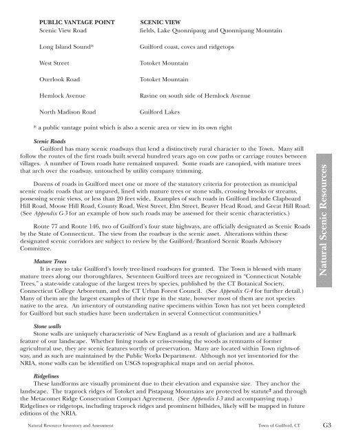
PUBLIC VANTAGE POINT SCENIC VIEW<br />
Scenic View Road fields, Lake Quonnipaug <strong>and</strong> Quonnipaug Mountain<br />
Long Isl<strong>and</strong> Sound* <strong>Guilford</strong> coast, coves <strong>and</strong> ridgetops<br />
West Street Totoket Mountain<br />
Overlook Road Totoket Mountain<br />
Hemlock Avenue Ravine on south side <strong>of</strong> Hemlock Avenue<br />
North Madison Road <strong>Guilford</strong> Lakes<br />
* a public vantage point which is also a scenic area or view in its own right<br />
Scenic Roads<br />
<strong>Guilford</strong> has many scenic roadways that lend a distinctively rural character to the <strong>Town</strong>. Many still<br />
follow the routes <strong>of</strong> the first roads built several hundred years ago on cow paths or carriage routes between<br />
villages. A number <strong>of</strong> <strong>Town</strong> roads have remained unpaved. Some roads are canopied, with mature trees<br />
that arch over the roadway, untouched by utility company trimming.<br />
Dozens <strong>of</strong> roads in <strong>Guilford</strong> meet one or more <strong>of</strong> the statutory criteria for protection as municipal<br />
scenic roads: roads that are unpaved, lined with mature trees or stone walls, crossing brooks or streams,<br />
possessing scenic views, or less than 20 feet wide. Examples <strong>of</strong> such roads in <strong>Guilford</strong> include Clapboard<br />
Hill Road, Moose Hill Road, County Road, West Street, Elm Street, Beaver Head Road, <strong>and</strong> Great Hill Road.<br />
(See Appendix G-3 for an example <strong>of</strong> how such roads may be assessed for their scenic characteristics.)<br />
Route 77 <strong>and</strong> Route 146, two <strong>of</strong> <strong>Guilford</strong>’s four state highways, are <strong>of</strong>ficially designated as Scenic Roads<br />
by the State <strong>of</strong> Connecticut. The view from the roadway is the scenic asset. Alterations within these<br />
designated scenic corridors are subject to review by the <strong>Guilford</strong>/Branford Scenic Roads Advisory<br />
Committee.<br />
Mature Trees<br />
It is easy to take <strong>Guilford</strong>’s lovely tree-lined roadways for granted. The <strong>Town</strong> is blessed with many<br />
mature trees along our thoroughfares. Seventeen <strong>Guilford</strong> trees are recognized in “Connecticut Notable<br />
Trees,” a state-wide catalogue <strong>of</strong> the largest trees by species, published by the CT Botanical Society,<br />
Connecticut College Arboretum, <strong>and</strong> the CT Urban Forest Council. (See Appendix G-4 for further detail.)<br />
Many <strong>of</strong> them are the largest examples <strong>of</strong> their type in the state, however most <strong>of</strong> them are not species<br />
native to the area. An inventory <strong>of</strong> outst<strong>and</strong>ing native specimens within <strong>Town</strong> has not yet been completed<br />
for <strong>Guilford</strong> but such studies have been undertaken in several Connecticut communities. 1<br />
Stone walls<br />
Stone walls are uniquely characteristic <strong>of</strong> New Engl<strong>and</strong> as a result <strong>of</strong> glaciation <strong>and</strong> are a hallmark<br />
feature <strong>of</strong> our l<strong>and</strong>scape. Whether lining roads or criss-crossing the woods as remnants <strong>of</strong> former<br />
agricultural use, they are scenic features worthy <strong>of</strong> preservation. Many are located within <strong>Town</strong> rights-<strong>of</strong>way,<br />
<strong>and</strong> as such are maintained by the Public Works Department. Although not yet inventoried for the<br />
NRIA, stone walls can be identified on USGS topographical maps <strong>and</strong> on aerial photos.<br />
Ridgelines<br />
These l<strong>and</strong>forms are visually prominent due to their elevation <strong>and</strong> expansive size. They anchor the<br />
l<strong>and</strong>scape. The traprock ridges <strong>of</strong> Totoket <strong>and</strong> Pistapaug Mountains are protected by statute 2 <strong>and</strong> through<br />
the Metacomet Ridge Conservation Compact Agreement. (See Appendix I-3 <strong>and</strong> accompanying map.)<br />
Ridgelines or ridgetops, including traprock ridges <strong>and</strong> prominent hillsides, likely will be mapped in future<br />
editions <strong>of</strong> the NRIA.<br />
<strong>Natural</strong> <strong>Resource</strong> <strong>Inventory</strong> <strong>and</strong> <strong>Assessment</strong> <strong>Town</strong> <strong>of</strong> <strong>Guilford</strong>, CT G3<br />
<strong>Natural</strong> Scenic <strong>Resource</strong>s