Natural Resource Inventory and Assessment - Town of Guilford
Natural Resource Inventory and Assessment - Town of Guilford
Natural Resource Inventory and Assessment - Town of Guilford

Create successful ePaper yourself
Turn your PDF publications into a flip-book with our unique Google optimized e-Paper software.
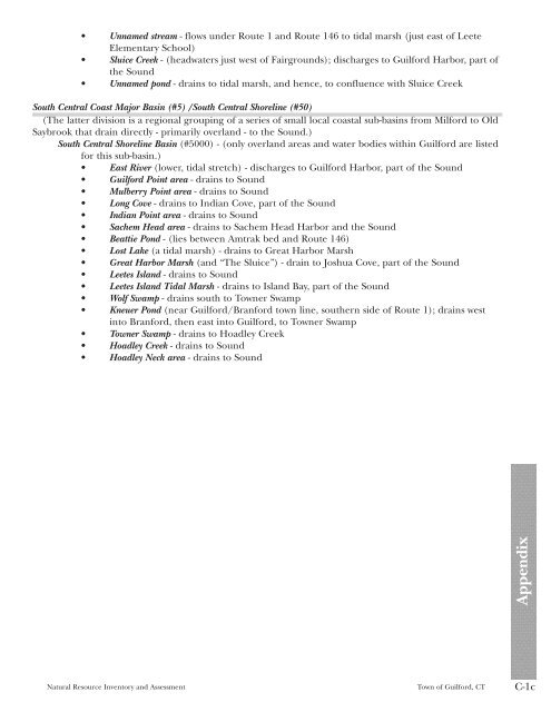
• Unnamed stream - flows under Route 1 <strong>and</strong> Route 146 to tidal marsh (just east <strong>of</strong> Leete<br />
Elementary School)<br />
• Sluice Creek - (headwaters just west <strong>of</strong> Fairgrounds); discharges to <strong>Guilford</strong> Harbor, part <strong>of</strong><br />
the Sound<br />
• Unnamed pond - drains to tidal marsh, <strong>and</strong> hence, to confluence with Sluice Creek<br />
South Central Coast Major Basin (#5) /South Central Shoreline (#50)<br />
(The latter division is a regional grouping <strong>of</strong> a series <strong>of</strong> small local coastal sub-basins from Milford to Old<br />
Saybrook that drain directly - primarily overl<strong>and</strong> - to the Sound.)<br />
South Central Shoreline Basin (#5000) - (only overl<strong>and</strong> areas <strong>and</strong> water bodies within <strong>Guilford</strong> are listed<br />
for this sub-basin.)<br />
• East River (lower, tidal stretch) - discharges to <strong>Guilford</strong> Harbor, part <strong>of</strong> the Sound<br />
• <strong>Guilford</strong> Point area - drains to Sound<br />
• Mulberry Point area - drains to Sound<br />
• Long Cove - drains to Indian Cove, part <strong>of</strong> the Sound<br />
• Indian Point area - drains to Sound<br />
• Sachem Head area - drains to Sachem Head Harbor <strong>and</strong> the Sound<br />
• Beattie Pond - (lies between Amtrak bed <strong>and</strong> Route 146)<br />
• Lost Lake (a tidal marsh) - drains to Great Harbor Marsh<br />
• Great Harbor Marsh (<strong>and</strong> “The Sluice”) - drain to Joshua Cove, part <strong>of</strong> the Sound<br />
• Leetes Isl<strong>and</strong> - drains to Sound<br />
• Leetes Isl<strong>and</strong> Tidal Marsh - drains to Isl<strong>and</strong> Bay, part <strong>of</strong> the Sound<br />
• Wolf Swamp - drains south to <strong>Town</strong>er Swamp<br />
• Kneuer Pond (near <strong>Guilford</strong>/Branford town line, southern side <strong>of</strong> Route 1); drains west<br />
into Branford, then east into <strong>Guilford</strong>, to <strong>Town</strong>er Swamp<br />
• <strong>Town</strong>er Swamp - drains to Hoadley Creek<br />
• Hoadley Creek - drains to Sound<br />
• Hoadley Neck area - drains to Sound<br />
<strong>Natural</strong> <strong>Resource</strong> <strong>Inventory</strong> <strong>and</strong> <strong>Assessment</strong> <strong>Town</strong> <strong>of</strong> <strong>Guilford</strong>, CT C-1c<br />
Appendix