Natural Resource Inventory and Assessment - Town of Guilford
Natural Resource Inventory and Assessment - Town of Guilford
Natural Resource Inventory and Assessment - Town of Guilford

Create successful ePaper yourself
Turn your PDF publications into a flip-book with our unique Google optimized e-Paper software.
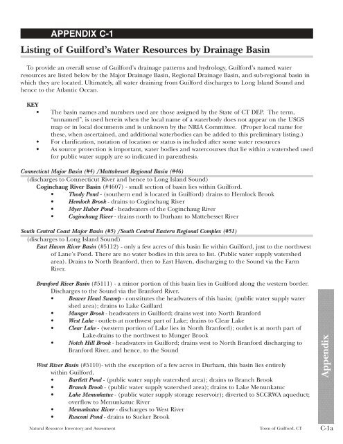
APPENDIX C-1<br />
Listing <strong>of</strong> <strong>Guilford</strong>’s Water <strong>Resource</strong>s by Drainage Basin<br />
To provide an overall sense <strong>of</strong> <strong>Guilford</strong>’s drainage patterns <strong>and</strong> hydrology, <strong>Guilford</strong>’s named water<br />
resources are listed below by the Major Drainage Basin, Regional Drainage Basin, <strong>and</strong> sub-regional basin in<br />
which they are located. Ultimately, all water draining from <strong>Guilford</strong> discharges to Long Isl<strong>and</strong> Sound <strong>and</strong><br />
hence to the Atlantic Ocean.<br />
KEY<br />
• The basin names <strong>and</strong> numbers used are those assigned by the State <strong>of</strong> CT DEP. The term,<br />
“unnamed”, is used herein when the local name <strong>of</strong> a waterbody does not appear on the USGS<br />
map or in local documents <strong>and</strong> is unknown by the NRIA Committee. (Proper local name for<br />
these, when ascertained, <strong>and</strong> additional waterbodies can be added to this preliminary listing.)<br />
• For clarification, notation <strong>of</strong> location or status is included after some water resources<br />
• As source protection is important, water bodies <strong>and</strong> watercourses that lie within a watershed used<br />
for public water supply are so indicated in parenthesis.<br />
Connecticut Major Basin (#4) /Mattabesset Regional Basin (#46)<br />
(discharges to Connecticut River <strong>and</strong> hence to Long Isl<strong>and</strong> Sound)<br />
Coginchaug River Basin (#4607) - small section <strong>of</strong> basin lies within <strong>Guilford</strong>.<br />
• Thody Pond - (southern end is located in <strong>Guilford</strong>) drains to Hemlock Brook<br />
• Hemlock Brook - drains to Coginchaug River<br />
• Myer Huber Pond - headwaters <strong>of</strong> the Coginchaug River<br />
• Coginchaug River - drains north to Durham to Mattebesset River<br />
South Central Coast Major Basin (#5) /South Central Eastern Regional Complex (#51)<br />
(discharges to Long Isl<strong>and</strong> Sound)<br />
East Haven River Basin (#5112) - only a few acres <strong>of</strong> this basin lie within <strong>Guilford</strong>, just to the northwest<br />
<strong>of</strong> Lane’s Pond. There are no water bodies in this area to list. (Public water supply watershed<br />
area). Drains to North Branford, then to East Haven, discharging to the Sound via the Farm<br />
River.<br />
Branford River Basin (#5111) - a minor portion <strong>of</strong> this basin lies in <strong>Guilford</strong> along the western border.<br />
Discharges to the Sound via the Branford River.<br />
• Beaver Head Swamp - constitutes the headwaters <strong>of</strong> this basin; (public water supply water<br />
shed area); drains to Lake Gaillard<br />
• Munger Brook - headwaters in <strong>Guilford</strong>; drains west into North Branford<br />
• West Lake - outlets at northwest part <strong>of</strong> Lake; drains to Clear Lake<br />
• Clear Lake - (western portion <strong>of</strong> Lake lies in North Branford); outlet is at north part <strong>of</strong><br />
Lake-drains to the northwest to Munger Brook<br />
• Notch Hill Brook - headwaters in <strong>Guilford</strong>; drains west to North Branford discharging to<br />
Branford River, <strong>and</strong> hence, to the Sound<br />
West River Basin (#5110)- with the exception <strong>of</strong> a few acres in Durham, this basin lies entirely<br />
within <strong>Guilford</strong>.<br />
• Bartlett Pond - (public water supply watershed area); drains to Branch Brook<br />
• Branch Brook - (public water supply watershed area); drains to Lake Menunkatuc<br />
• Lake Menunkatuc - (public water supply storage reservoir); diverted to SCCRWA aqueduct;<br />
overflow to Menunkatuc River<br />
• Menunkatuc River - discharges to West River<br />
• Rusconi Pond - drains to Sucker Brook<br />
<strong>Natural</strong> <strong>Resource</strong> <strong>Inventory</strong> <strong>and</strong> <strong>Assessment</strong> <strong>Town</strong> <strong>of</strong> <strong>Guilford</strong>, CT C-1a<br />
Appendix