Natural Resource Inventory and Assessment - Town of Guilford
Natural Resource Inventory and Assessment - Town of Guilford
Natural Resource Inventory and Assessment - Town of Guilford

Create successful ePaper yourself
Turn your PDF publications into a flip-book with our unique Google optimized e-Paper software.
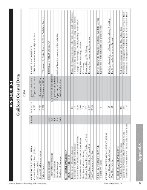
APPENDIX B-1<br />
<strong>Guilford</strong> Coastal Data<br />
2004<br />
GUILFORD'S COASTAL AREA # miles ACREAGE percent l<strong>and</strong> area EXAMPLES/COMMENTS<br />
Coastal Boundary Area (CBA) 5,235 17.7 percent <strong>of</strong> town 1,000' l<strong>and</strong>ward <strong>of</strong> mean high tide level<br />
(8.2 square miles)<br />
Coastal flood hazard areas 2,273 43 percent <strong>of</strong> CBA<br />
Tidal wetl<strong>and</strong>s 1,271 24 percent <strong>of</strong> CBA 47% owned by State, <strong>Town</strong>, GLCT or Audubon Society<br />
Shorefront length 13.3 FRONTAGE AREAS OVERLAP<br />
Tidal wetl<strong>and</strong>s frontage 5.9 17 percent <strong>of</strong> the shoreline<br />
Rocky shoreline 8.8 67 percent <strong>of</strong> shoreline<br />
Beach frontage 1.4 10.8 percent <strong>of</strong> shoreline 60% <strong>of</strong> beaches are more like tidal flats<br />
Residential frontage 10.9 80% <strong>of</strong> shoreline<br />
SHORELINE OWNERSHIP<br />
TOWN OF GUILFORD<br />
Jacob's Beach (Seaside Avenue) 25 Picnic shelter, playground, volleyball, boat rack, bathhouse<br />
Chittenden Park (Seaside Avenue) 14 4 bocci courts, pedestrian access to Long Isl<strong>and</strong> Sound<br />
<strong>Guilford</strong> <strong>Town</strong> Marina (Whitfield Street) 12.94 1 ramps, 14 moorings, 138 slips, fishing, water views<br />
Grass Isl<strong>and</strong> (south bank <strong>of</strong> East River) 29.6 Fishing, bird watching, picnics<br />
Shell Beach (Leete's Isl<strong>and</strong>) 0.5 Clamming<br />
Chaffinch Isl<strong>and</strong> Park (on Mulberry Point) 22 Picnic tables, grills, fishing<br />
Trolley Road (100' x 50' s<strong>and</strong> lot) 0.12 Parking for clammers, kayakers, etc<br />
Total <strong>Town</strong>-owned shoreline 93.62<br />
US FISH & WILDLIFE SERVICE Part <strong>of</strong> Stewart B. McKinney National Wildlife Refuge<br />
Faulkner's Isl<strong>and</strong> 5 Lighthouse & bird sanctuary. No public access<br />
CT DEP WILDLIFE MANAGEMENT AREAS<br />
Great Harbor (Isl<strong>and</strong> Creek) 147 Fishing, clamming, crabbing, birdwatching, kayaking<br />
East River Marsh 147 Public access by boat, none by road<br />
OTHER COASTAL PRESERVES<br />
<strong>Guilford</strong> Salt Meadows Sanctuary 235 Salt marsh: animal <strong>and</strong> plant life, nature trail<br />
Jarod Eliot Preserve (Mulberry Point Road) 36 Owned <strong>and</strong> managed by <strong>Guilford</strong> L<strong>and</strong> Conservation Trust<br />
Spencer's Creek Preserve (Three Mile Course Road) 11.5 Owned <strong>and</strong> managed by <strong>Guilford</strong> L<strong>and</strong> Conservation Trust<br />
<strong>Natural</strong> <strong>Resource</strong> <strong>Inventory</strong> <strong>and</strong> <strong>Assessment</strong> <strong>Town</strong> <strong>of</strong> <strong>Guilford</strong>, CT<br />
Appendix<br />
B-1