Caboolture Region Water Quality Study - Moreton Bay Regional ...
Caboolture Region Water Quality Study - Moreton Bay Regional ...
Caboolture Region Water Quality Study - Moreton Bay Regional ...

Create successful ePaper yourself
Turn your PDF publications into a flip-book with our unique Google optimized e-Paper software.
<strong>Caboolture</strong> <strong>Water</strong> <strong>Quality</strong> <strong>Study</strong><br />
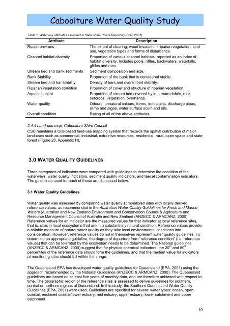
Table 1. <strong>Water</strong>way attributes assessed in State of the Rivers Reporting (SoR, 2001)<br />
Attribute<br />
Reach environs<br />
Channel habitat diversity<br />
Stream bed and bank sediments<br />
Bank Stability<br />
Stream bed and bar stability<br />
Riparian vegetation condition<br />
Aquatic habitat<br />
<strong>Water</strong> quality<br />
Overall condition<br />
Description<br />
The extent of clearing, weed invasion in riparian vegetation, land<br />
use, vegetation types and forms of disturbance.<br />
Proportion of various channel habitats, reported as an index of<br />
habitat diversity. Includes pools, riffles, backwaters, waterfalls,<br />
glides and runs.<br />
Sediment composition and size.<br />
Proportion of the bank that is considered stable.<br />
Density of bars and overall bed stability.<br />
Proportion of cover and structure of riparian vegetation.<br />
Proportion of stream bed covered by in-stream debris, rock<br />
outcrops, vegetation, overhangs.<br />
Odours, unnatural colours, forms, iron stains, discharge pipes,<br />
slime and algae, water surface scum and oils.<br />
Rating of all of the above attributes.<br />
2.4.4 Land-use map, <strong>Caboolture</strong> Shire Council<br />
CSC maintains a GIS-based land-use mapping system that records the spatial distribution of major<br />
land-uses such as commercial, industrial, extractive resources, residential, rural, open space and state<br />
forest (Figure 26, Appendix H).<br />
3.0 WATER QUALITY GUIDELINES<br />
Three categories of indicators were compared with guidelines to determine the condition of the<br />
waterways: water quality indicators, sediment quality indicators, and faecal contamination indicators.<br />
The guidelines used for each of these are discussed below.<br />
3.1 <strong>Water</strong> <strong>Quality</strong> Guidelines<br />
<strong>Water</strong> quality was assessed by comparing water quality at monitored sites with locally derived<br />
reference values, as recommended in the Australian <strong>Water</strong> <strong>Quality</strong> Guidelines for Fresh and Marine<br />
<strong>Water</strong>s (Australian and New Zealand Environment and Conservation Council & Agriculture and<br />
Resource Management Council of Australia and New Zealand (ANZECC & ARMCANZ, 2000).<br />
Reference values for an indicator are the measured values for that indicator at local reference sites,<br />
that is, sites in local ecosystems that are in a substantially natural condition. Reference values provide<br />
a reliable measure of natural water quality as they take local environmental conditions into<br />
consideration. However, reference values do not in themselves represent water quality guidelines. To<br />
determine an appropriate guideline, the degree of departure from “reference condition” (i.e. reference<br />
values) that can be tolerated by the ecosystem needs to be determined. The National guidelines<br />
(ANZECC & ARMCANZ, 2000) suggest that for physico-chemical indicators, the 20 th and 80 th<br />
percentiles of the reference data should form the guidelines, and that the median value for indicators<br />
at monitoring sites should fall within this range.<br />
The Queensland EPA has developed water quality guidelines for Queensland (EPA, 2001) using the<br />
approach recommended by the National Guidelines (ANZECC & ARMCANZ, 2000). The Queensland<br />
guidelines are based on at least five years of monthly data, and are therefore unbiased with respect to<br />
time. The geographic region of the reference sites is assessed to derive guidelines for southern,<br />
central or northern regions of Queensland. In this study, the Southern Queensland <strong>Water</strong> <strong>Quality</strong><br />
Guidelines (EPA, 2001) were used. Guidelines are specified for several water types: ocean, open<br />
coastal, enclosed coastal/lower estuary, mid estuary, upper estuary, lower catchment and upper<br />
catchment.<br />
10

![Kumbartcho Brochure [PDF 540KB] - Moreton Bay Regional Council](https://img.yumpu.com/47220970/1/190x101/kumbartcho-brochure-pdf-540kb-moreton-bay-regional-council.jpg?quality=85)