

2010 Metro Mitigation Plan
2010 Metro Mitigation Plan
2010 Metro Mitigation Plan

Create successful ePaper yourself
Turn your PDF publications into a flip-book with our unique Google optimized e-Paper software.
Interstate 24 and Briley Parkway; to the north by Interstate 40; to the east by J. Percy Priest<br />
Lake; and to the southeast by the Davidson County line. The subarea includes older suburban<br />
subdivisions, new development, large employers and rural lands.<br />
Subarea 14 – Donelson – Hermitage<br />
This subarea is located on the eastern side of Davidson County and is bounded by the<br />
Cumberland River to the west and north; Sumner and Wilson Counties to the northeast and<br />
east; Percy Priest Lake, Couchville Pike, Nashville International Airport, and I-40 to the<br />
south; and Spence Lane and the CSX railroad to the west. Most of the subarea has gently<br />
rolling terrain with steeply sloping land limited mostly to corridors along waterways. Major<br />
water bodies in this subarea include the Cumberland River, J. Percy Priest Lake, Stone’s<br />
River, Stoner’s Creek, and Mill Creek.<br />
Almost half of the land currently developed is residential. Commercial concentrations are in<br />
the Donelson and Hermitage areas. There is a major mixed entertainment/commercial<br />
concentration in Pennington Bend that includes the Opryland Hotel, the Grand Ole Opry<br />
House, and Opry Mills Shopping Mall. An estimated one-fourth of the subarea’s land is<br />
currently vacant, a significant portion of which is affected by flooding.<br />
POPULATION<br />
Since its settlement in 1779, Nashville has grown to become Tennessee’s largest city.<br />
Together, Nashville and Davidson County contain a population of 626,144, according to the<br />
US Census Bureau.<br />
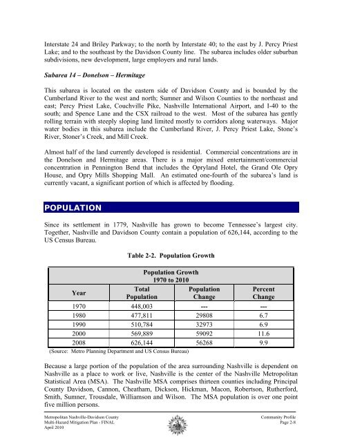
Year<br />
Table 2-2. Population Growth<br />
Total<br />
Population<br />
Population Growth<br />
1970 to <strong>2010</strong><br />
Population<br />
Change<br />
Percent<br />
Change<br />
1970 448,003 --- ---<br />
1980 477,811 29808 6.7<br />
1990 510,784 32973 6.9<br />
2000 569,889 59092 11.6<br />
2008 626,144 56268 9.9<br />
(Source: <strong>Metro</strong> <strong>Plan</strong>ning Department and US Census Bureau)<br />
Because a large portion of the population of the area surrounding Nashville is dependent on<br />
Nashville as a place to work or live, Nashville is the center of the Nashville <strong>Metro</strong>politan<br />
Statistical Area (MSA). The Nashville MSA comprises thirteen counties including Principal<br />
County Davidson, Cannon, Cheatham, Dickson, Hickman, Macon, Robertson, Rutherford,<br />
Smith, Sumner, Trousdale, Williamson and Wilson. The MSA population is over one point<br />
five million persons.<br />
<strong>Metro</strong>politan Nashville-Davidson County<br />
Community Profile<br />
Multi-Hazard <strong>Mitigation</strong> <strong>Plan</strong> - FINAL Page 2-8<br />
April <strong>2010</strong>