

2010 Metro Mitigation Plan
2010 Metro Mitigation Plan
2010 Metro Mitigation Plan

You also want an ePaper? Increase the reach of your titles
YUMPU automatically turns print PDFs into web optimized ePapers that Google loves.
Damage Reach 1<br />
Damage Reach 2<br />
Damage Reach 3<br />
Reach 2 starts at Welch Road (river mile 1.53) and continues upstream through a residential<br />
area above Blackman Road and ends near Edmondson Pike and Brewer Drive at river mile<br />
3.27. Damage Reach 3 starts near Edmondson Pike and Huntingdon Parkway at river mile<br />
4.45 continuing to a private driveway at river mile 4.73. Table 4-10 provides specific damage<br />
information for the damage reach.<br />
Repetitive Loss Areas<br />
The repetitive loss area is located between Nolensville Pike and Briarwood Drive (see<br />
Appendix C, Figure C.7b). Currently, there are fourteen properties reporting repetitive losses<br />
due to flooding on Sevenmile Creek. In addition, the associated repetitive loss areas<br />
encompass 160 properties. The Sevenmile Creek Storm Water Basin <strong>Plan</strong>, completed in<br />
2001, identifies these flood-prone areas and alternative solutions to reduce existing flooding<br />
problems.<br />
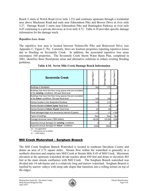
Table 4-10. Seven Mile Creek Damage Reach Information<br />
Sevenmile Creek<br />
Buildings in floodplain 160 171 6<br />
Buildings that have first floor living spaces that are inundated<br />
at the existing conditions 100-year flood level 0 0 0<br />
Buildings that have first floor living spaces that are inundated<br />
at the future conditions 100-year flood level 139 158 1<br />
Homes located in the designated floodway 149 213 33<br />
Homes flooded at future 2-year flood level 1 4 0<br />
Homes flooded at future 10-year flood level 20 42 0<br />
Flood damages begin at a recurrence interval of (years) < 2 < 2 >100<br />
Types of buildings Res Res Res<br />
Average structural value (1999 dollars) 69.5K 123.5K 123K<br />
Expected annual damages for existing conditions 0 0 0<br />
Expected annual damages for future conditions 233K 394K 1K<br />
n/a – not applicable<br />
* - information not available<br />
K – 1,000 dollars<br />
Mill Creek Watershed – Sorghum Branch<br />
The Mill Creek Sorghum Branch Watershed is located in southeast Davidson County and<br />
drains an area of 2.72 square miles. Stream flow within the watershed is generally in a<br />
northerly direction and empties into Mill Creek at Stream Mile 8.45 of Mill Creek. Maximum<br />
elevation at the upstream watershed divide reaches about 850 feet and drops to elevation 465<br />
feet at the main stream confluence with Mill Creek. The Sorghum Branch watershed was<br />
divided into 14 sub-basins and is a relatively long and narrow watershed. Sorghum Branch is<br />
typified by narrow valleys with steep side slopes that transition into a rolling terrain on top of<br />
the ridges.<br />
<strong>Metro</strong>politan Nashville - Davidson County<br />
Hazard Identification<br />
Multi-Hazard <strong>Mitigation</strong> <strong>Plan</strong> Page 4-28<br />
April <strong>2010</strong>