- Page 1 and 2: Metropolitan Nashville-Davidson Cou
- Page 3 and 4: 4.2 Vulnerability Assessment ......
- Page 5 and 6: LIST OF FIGURES Figure 2-1 Metropol
- Page 7 and 8: USDA USGA WCT WNV United States Dep
- Page 9: Metropolitan Nashville-Davidson Cou
- Page 12 and 13: equired revision every 5 years. The
- Page 14 and 15: Figure 2-1. Metropolitan Nashville-
- Page 16 and 17: Subarea 1 - Joelton Joelton is loca
- Page 18 and 19: Nashville, coupled with the concent
- Page 20 and 21: Interstate 24 and Briley Parkway; t
- Page 22 and 23: (This page has been left blank inte
- Page 24 and 25: Figure 3-1. Similarity Between DMA
- Page 26 and 27: Step 2: Involve the Public In addit
- Page 28 and 29: Step 5: Assess the Problem Once the
- Page 30 and 31: (This page has been left blank inte
- Page 32 and 33: (This page has been left blank inte
- Page 34 and 35: Table 4-1. Federal Disaster Declara
- Page 36 and 37: (This page has been left blank inte
- Page 38 and 39: Figure 4-2. Dams and Levees within
- Page 40 and 41: management. Total storage capacity
- Page 42 and 43: infrequent occurrence. There has ne
- Page 44 and 45: Likelihood of Future Occurrences Th
- Page 48 and 49: All streams within Metro Nashville,
- Page 50 and 51: Nashville entered the flood insuran
- Page 52 and 53: Damage Reach 1 Damage Reach 2 Damag
- Page 54 and 55: Dry Creek Watershed The Dry Creek W
- Page 56 and 57: performed. Primarily a rural portio
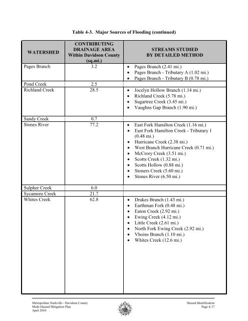
- Page 58 and 59: Damage Reach 1 Damage Reach 2 Damag
- Page 60 and 61: Damage Reach 1 Damage Reach 2 Damag
- Page 62 and 63: Table 4-13. Pages Branch Damage Rea
- Page 64 and 65: Table 4-14. Richland Creek Damage R
- Page 66 and 67: Damage Reach 1 Damage Reach 2 Damag
- Page 68 and 69: Damage Reach 1 Damage Reach 2 Damag
- Page 70 and 71: 2.96. Damage Reach 12 is located on
- Page 72 and 73: Cumberland River The Cumberland Riv
- Page 74 and 75: The Southern Appalachian Seismic Zo
- Page 76 and 77: 40g 30g 25g 20g 15g 10g 9g 8g 7g 6g
- Page 78 and 79: (This page left blank intentionally
- Page 80 and 81: Figure 4-10. Evidence of Landslides
- Page 82 and 83: Figure 4-11b. Slopes greater than 2
- Page 84 and 85: Figure 4.13 Karst Hazard Map of Ten
- Page 86 and 87: Human cases have been reported in a
- Page 88 and 89: (This page has been left blank inte
- Page 90 and 91: The PDSI indicates that for the per
- Page 92 and 93: (This page has been left blank inte
- Page 94 and 95: Figure 4-18. Tennessee Forestry Dis
- Page 96 and 97:
how hot it feels to an individual w
- Page 98 and 99:
(This page has been left blank inte
- Page 100 and 101:
Figure 4-21. Average Number of Thun
- Page 102 and 103:
(This page left blank intentionally
- Page 104 and 105:
Past Occurrences Several severe tor
- Page 106 and 107:
Past Occurrences There have been 16
- Page 108 and 109:
Critical Facilities Of significant
- Page 110 and 111:
Scientific Name Common Name Federal
- Page 112 and 113:
Historic and Natural Resources are
- Page 114 and 115:
West Nile Virus is spread through m
- Page 116 and 117:
DAM & LEVEE FAILURES Risk - Moderat
- Page 118 and 119:
WNQM AM 1300; WUPX UPN 30; WVOL AM
- Page 120 and 121:
Table 4-31. Earthquake Hazard Damag
- Page 122 and 123:
(This page left blank intentionally
- Page 124 and 125:
Figure 4-25 Tornado Siren Locations
- Page 126 and 127:
(This page left blank intentionally
- Page 128 and 129:
Table 4-33. Metropolitan Nashville-
- Page 130 and 131:
Evaluation of Existing Capabilities
- Page 132 and 133:
Harpeth River - Newsom Station Road
- Page 134 and 135:
4. MWS has prioritized Capital Impr
- Page 136 and 137:
GOAL #3: Objective 3.1: Objective 3
- Page 138 and 139:
measures. Team members were allowed
- Page 140 and 141:
2009 Update: Since the creation of
- Page 142 and 143:
Community Benefit: Potential fundin
- Page 144 and 145:
staff gages were installed in 2009
- Page 146 and 147:
Existing permit procedures should b
- Page 148 and 149:
Community Benefit: Life safety, Pot
- Page 150 and 151:
• Develop public-private partners
- Page 152 and 153:
2009 Update: MWS continues to send
- Page 154 and 155:
Metro officials should talk to thei
- Page 156 and 157:
(This page has been left blank inte
- Page 158 and 159:
COMPLETED ACTION 4: Double the numb
- Page 160 and 161:
(This page has been left blank inte
- Page 162 and 163:
• Construct tornado saferooms and
- Page 164 and 165:
(This page has been left blank inte
- Page 166 and 167:
With the adoption of this plan, the
- Page 168 and 169:
(This page has been left blank inte
- Page 170 and 171:
(This page left blank intentionally
- Page 172 and 173:
of the CPT. In addition, technical
- Page 174 and 175:
PROMULGATION STATMENT Date: TBD To:
- Page 176 and 177:
(This page has been left blank inte
- Page 178 and 179:
(This page left blank intentionally
- Page 180 and 181:
2. Multi-Hazard Mitigation Plan Sta
- Page 182 and 183:
(This page left blank intentionally
- Page 184 and 185:
(This page left blank intentionally
- Page 186 and 187:
(This page has been left blank inte
- Page 188 and 189:
METROPOLITAN GOVERNMENT OF NASHVILL
- Page 190 and 191:
Figure A-5 Mass email sent out from
- Page 192 and 193:
(This page left blank intentionally
- Page 194 and 195:
(This page has been left blank inte
- Page 196 and 197:
FLOODING-1 No. Location Historical
- Page 198 and 199:
FLOODING-3 No. Location Historical
- Page 200 and 201:
EARTHQUAKES-2 No. Date Richter Magn
- Page 202 and 203:
INFESTATIONS-1 West Nile Virus Loca
- Page 204 and 205:
WILDFIRES-1 No. Location Year Histo
- Page 206 and 207:
EXTREME COLD TEMPERATURES-2 No. Loc
- Page 208 and 209:
EXTREME HOT TEMPERATURES-1 No. Loca
- Page 210 and 211:
THUNDERSTORMS-1 No. Location Histor
- Page 212 and 213:
THUNDERSTORMS-3 No. Location Histor
- Page 214 and 215:
THUNDERSTORMS-5 No. Location Histor
- Page 216 and 217:
THUNDERSTORMS-7 No. Location Histor
- Page 218 and 219:
THUNDERSTORMS-9 No. Location Histor
- Page 220 and 221:
TORNADOES-2 No. Location Historical
- Page 222 and 223:
TORNADOES-4 No. Location Historical
- Page 224 and 225:
WINTER STORMS-1 No. Location Histor
- Page 226 and 227:
WINTER STORMS-3 No. Location Histor
- Page 228 and 229:
WINTER STORMS-5 No. Location Histor
- Page 230 and 231:
Metropolitan Nashville - Davidson C
- Page 232 and 233:
MCALPINE AV Cooper Creek DR 3 HART
- Page 234 and 235:
Trib. No. 3 GALLATIN PK OLD HICKORY
- Page 236 and 237:
HEATH RD BUFFALO RD HUNTWICK TRL HW
- Page 239 and 240:
NOLENSVILLE PK Sevenmile Creek DR 1
- Page 241 and 242:
Mill Creek Sorghum Branch ANTIOCH P
- Page 244 and 245:
HART LN BRICK CHURCH PK I- 65 §¨
- Page 246 and 247:
SUMMERLY DR W HILLWOOD DR DARDEN PL
- Page 248 and 249:
Stones River STEWARTS FERRY PK reek
- Page 250 and 251:
SAUNDERSVILLE RD SHUTE LN ANDREW JA
- Page 253 and 254:
Cumberland River RIVER RD RIVER ROA
- Page 255:
Cumberla nd River Browns Creek DR 1
- Page 258 and 259:
Metropolitan Nashville - Davidson C
- Page 260 and 261:
Metropolitan Nashville Department o
- Page 262 and 263:
Reconnaissance Report for Flood Dam
- Page 264:
Extreme Temperatures Chronology of