Bexhill Town Profile - Rother District Council
Bexhill Town Profile - Rother District Council
Bexhill Town Profile - Rother District Council

Create successful ePaper yourself
Turn your PDF publications into a flip-book with our unique Google optimized e-Paper software.
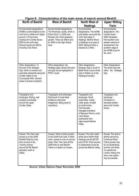
Figure 9: Characteristics of the main areas of search around <strong>Bexhill</strong><br />
North of <strong>Bexhill</strong> West of <strong>Bexhill</strong> North West of<br />
Hastings<br />
Environmental designations:<br />
AONB is some distance to the<br />
north but is visible from higher<br />
ground. A Flood Zone<br />
overlays the Combe Haven<br />
SSSI to the north east.<br />
Several woods are SNCIs,<br />
including Cole Wood.<br />
Environmental designations:<br />
The Pevensey Levels, which is<br />
Flood Zone 3, a SSSI and<br />
Ramsar site, limits westward<br />
growth. There are SNCIs and<br />
an SSSI in the High Woods<br />
area.<br />
Environmental<br />
designations: The AONB<br />
quite tightly surrounds the<br />
north west edge of<br />
Hastings. Marline Wood<br />
in Hastings is an area of<br />
SSSI. Beauport Park is<br />
classed as a SNCI.<br />
Upper Wilting<br />
Farm<br />
Environmental<br />
designations: The<br />
Combe Haven<br />
SSSI/ floodplain<br />
limit southern and<br />
western extents of<br />
development, the<br />
southern edge of<br />
the AONB is just to<br />
the north.<br />
Other designations: To<br />
the east is the Strategic<br />
Gap, which is overlain and<br />
extended westwards along the<br />
Combe Valley by the<br />
Countryside Park. Several<br />
areas of ancient woodland.<br />
Other designations: No<br />
Strategic gaps; Broad Oak park<br />
and golf course highlighted in<br />
PPG17 audit.<br />
Other designations:<br />
Strategic Gap to south of<br />
Battle Road covers whole<br />
area in <strong>Rother</strong> up to the<br />
Hastings boundary<br />
Other designations:<br />
The whole area lies<br />
within the Strategic<br />
Gap<br />
Topography and<br />
landscape: Rolling, well<br />
wooded countryside<br />
around the upper<br />
Combe Valley.<br />
Topography and landscape:<br />
Patchwork of small fields<br />
divided by tree-lined<br />
hedgerows, falling away to<br />
marshland.<br />
Topography and<br />
landscape: Small<br />
scale fields, mostly<br />
under grass, divided<br />
by small woods.<br />
Commercially<br />
managed woodland<br />
of Beauport Park to north.<br />
Land slopes<br />
southwards from<br />
ridge toward Marline<br />
Valley.<br />
Topography and<br />
landscape:<br />
Farmland on<br />
elevated position<br />
above the Combe<br />
Haven.<br />
Access: The main road<br />
access is by the A269<br />
Ninfield Road but may<br />
also connect to the<br />
‘country avenue’<br />
around the NE <strong>Bexhill</strong><br />
allocation north of<br />
Sidley.<br />
Access: There is direct access<br />
to the A259 trunk road. Further<br />
north, access is only via narrow<br />
lanes. Pear Tree Lane off the<br />
A269 links to west <strong>Bexhill</strong>.<br />
There is a station at Cooden.<br />
Access: The main roads<br />
which serve North West<br />
Hastings are the B2159<br />
and A2100. Direct access<br />
to Queensway would be<br />
across the Marline Valley.<br />
Access: The area is<br />
directly served by<br />
Crowhurst Road.<br />
Future access may<br />
be via Queensway<br />
and the Link Road.<br />
It is astride the<br />
London railway line<br />
and a new station<br />
may be possible.<br />
Source: Urban Options Paper November 2008<br />
22