Bexhill Town Profile - Rother District Council
Bexhill Town Profile - Rother District Council
Bexhill Town Profile - Rother District Council

Create successful ePaper yourself
Turn your PDF publications into a flip-book with our unique Google optimized e-Paper software.
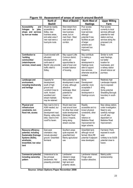
Figure 10: Assessment of areas of search around <strong>Bexhill</strong><br />
North of<br />
<strong>Bexhill</strong><br />
West of <strong>Bexhill</strong> North West of<br />
Hastings<br />
Upper Wilting<br />
Farm<br />
Accessibility and<br />
linkages to jobs,<br />
shops and services<br />
by non-car modes<br />
Would be readily<br />
accessible to<br />
Sidley, new<br />
business areas,<br />
and wider area if<br />
new road were a<br />
bus/cycle route.<br />
Most distant from<br />
town centre and<br />
new business<br />
areas, but on<br />
main East - West<br />
road and rail<br />
corridor.<br />
Poor access<br />
currently to<br />
local services<br />
although<br />
potential if new<br />
facilities as part<br />
of larger<br />
scheme and<br />
improved bus<br />
frequency.<br />
Poor access<br />
currently to local<br />
services although<br />
potential for new<br />
station and bus<br />
services along the<br />
proposed Link<br />
Road.<br />
Contribution to<br />
‘building<br />
communities’<br />
(retain/improve<br />
services; mixed uses)<br />
Could dovetail with<br />
allocated<br />
development to<br />
north-east of<br />
<strong>Bexhill</strong>; also provide<br />
traffic relief to<br />
Sidley.<br />
May support Little<br />
Common district<br />
centre, job<br />
opportunities to<br />
west of town and<br />
broader balance<br />
of housing.<br />
May contribute<br />
to making a<br />
larger<br />
development in<br />
Hastings more<br />
able to support<br />
new services,<br />
otherwise would be<br />
isolated.<br />
Similar to north<br />
west Hastings,<br />
but better<br />
location for<br />
businesses, and<br />
a railway station<br />
should reduce car<br />
journeys.<br />
Landscape and<br />
environment,<br />
including biodiversity<br />
and heritage<br />
Capacity for<br />
development<br />
south of high<br />
ground and<br />
Lunsford Cross to<br />
north. Ancient<br />
woodland and<br />
stream habitats<br />
may be retained.<br />
More potential for<br />
development in east<br />
of area, although<br />
attractive<br />
landscape. Most<br />
potential for<br />
impact on<br />
Ramsar site<br />
Some<br />
Development<br />
potential, more<br />
acceptable if<br />
proposed<br />
development in<br />
Hastings occurs.<br />
Relatively high<br />
Landscape impacts<br />
due to exposed<br />
siting.<br />
Some potential<br />
Straddling Borough<br />
boundary in southeast.<br />
Physical and<br />
infrastructure<br />
constraints, incl.<br />
flood risk, access<br />
New road to link to<br />
A269 needed, but<br />
potential<br />
development road.<br />
Sloping, valley-side<br />
sites; need to limit<br />
runoff to haven.<br />
Would need new<br />
road around town<br />
for other than small<br />
scale development.<br />
Moderate Flood<br />
Zone 2 impacts,<br />
being along<br />
stream courses<br />
Readily<br />
accessible and no<br />
known physical<br />
constraints, other<br />
than<br />
reliance on<br />
Baldslow Road<br />
Improvement for<br />
larger scheme.<br />
New railway station,<br />
under investigation.<br />
Need to very<br />
carefully manage<br />
run-off; also<br />
dependent on<br />
Baldslow Road<br />
Improvement.<br />
Resource efficiency<br />
potential, including<br />
Sustainable Drainage<br />
Systems (SUDs),<br />
wind/solar,<br />
brownfield, low value<br />
land<br />
East-west<br />
orientation; may<br />
include elevated<br />
ground. Greenfield<br />
farmland<br />
Southern areas<br />
quite exposed. All<br />
greenfield land.<br />
Mainly agricultural<br />
use.<br />
Greenfield land,<br />
although not all<br />
farmed. More RE<br />
potential if adjacent<br />
area developed.<br />
Farmland. Parts<br />
exposed to southwest.<br />
Unlikely to be SUDS<br />
potential close to<br />
haven.<br />
Commercial potential,<br />
Including ownership<br />
pattern<br />
Understood to be<br />
few principal<br />
landowners. Not<br />
presently promoted.<br />
Landowner<br />
interest in large<br />
areas; relatively<br />
high land and<br />
property values.<br />
Landowner interest.<br />
Fringe urban<br />
location attractive.<br />
Mainly public<br />
landownership.<br />
Source: Urban Options Paper November 2008<br />
23