Lakes and Watercourses
Lakes and Watercourses
Lakes and Watercourses

You also want an ePaper? Increase the reach of your titles
YUMPU automatically turns print PDFs into web optimized ePapers that Google loves.
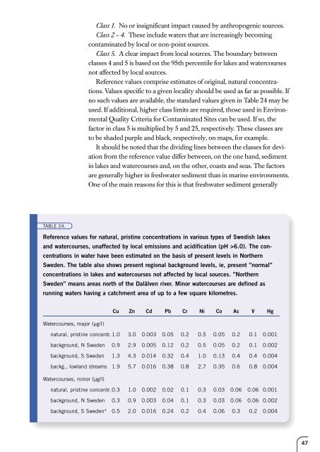
Class 1. No or insignificant impact caused by anthropogenic sources.<br />
Class 2 – 4. These include waters that are increasingly becoming<br />
contaminated by local or non-point sources.<br />
Class 5. A clear impact from local sources. The boundary between<br />
classes 4 <strong>and</strong> 5 is based on the 95th percentile for lakes <strong>and</strong> watercourses<br />
not affected by local sources.<br />
Reference values comprise estimates of original, natural concentrations.<br />
Values specific to a given locality should be used as far as possible. If<br />
no such values are available, the st<strong>and</strong>ard values given in Table 24 may be<br />
used. If additional, higher class limits are required, those used in Environmental<br />
Quality Criteria for Contaminated Sites can be used. If so, the<br />
factor in class 5 is multiplied by 5 <strong>and</strong> 25, respectively. These classes are<br />
to be shaded purple <strong>and</strong> black, respectively, on maps, for example.<br />
It should be noted that the dividing lines between the classes for deviation<br />
from the reference value differ between, on the one h<strong>and</strong>, sediment<br />
in lakes <strong>and</strong> watercourses <strong>and</strong>, on the other, coasts <strong>and</strong> seas. The factors<br />
are generally higher in freshwater sediment than in marine environments.<br />
One of the main reasons for this is that freshwater sediment generally<br />
TABLE 24.<br />
Reference values for natural, pristine concentrations in various types of Swedish lakes<br />
<strong>and</strong> watercourses, unaffected by local emissions <strong>and</strong> acidification (pH >6.0). The concentrations<br />
in water have been estimated on the basis of present levels in Northern<br />
Sweden. The table also shows present regional background levels, ie, present ”normal”<br />
concentrations in lakes <strong>and</strong> watercourses not affected by local sources. ”Northern<br />
Sweden” means areas north of the Dalälven river. Minor watercourses are defined as<br />
running waters having a catchment area of up to a few square kilometres.<br />
Cu Zn Cd Pb Cr Ni Co As V Hg<br />
<strong>Watercourses</strong>, major (µg/l)<br />
natural, pristine concentr. 1.0 3.0 0.003 0.05 0.2 0.5 0.05 0.2 0.1 0.001<br />
background, N Sweden 0.9 2.9 0.005 0.12 0.2 0.5 0.05 0.2 0.1 0.002<br />
background, S Sweden 1.3 4.3 0.014 0.32 0.4 1.0 0.13 0.4 0.4 0.004<br />
backg., lowl<strong>and</strong> streams 1.9 5.7 0.016 0.38 0.8 2.7 0.35 0.6 0.8 0.004<br />
<strong>Watercourses</strong>, minor (µg/l)<br />
natural, pristine concentr. 0.3 1.0 0.002 0.02 0.1 0.3 0.03 0.06 0.06 0.001<br />
background, N Sweden 0.3 0.9 0.003 0.04 0.1 0.3 0.03 0.06 0.06 0.002<br />
background, S Sweden* 0.5 2.0 0.016 0.24 0.2 0.4 0.06 0.3 0.2 0.004<br />
47


![Accommodation booking form [PDF]](https://img.yumpu.com/39471785/1/184x260/accommodation-booking-form-pdf.jpg?quality=85)