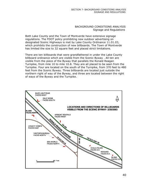
SECTION 7- BACKGROUND CONDITIONS ANALYSISSIGNAGE AND REGULATIONSBACKGROUND CONDITIONS ANALYSISSignage and RegulationsBoth Lake County and the Town of Montverde have extensive signageregulations. The FDOT policy prohibiting new outdoor advertising ondesignated <strong>Scenic</strong> <strong>Highways</strong> is met by Lake County Ordinance 11.01.03,which prohibits the construction of new billboards. The Town of Montverdehas limited the size to 32 square feet and placed strict limitations.There are ten billboards that were grandfathered in under the Lake Countybillboard ordinance which are visible from the <strong>Scenic</strong> Byway . All ten arevisible from the piece of the Byway that parallels the Ronald ReaganTurnpike, from mile 10 to mile 10.8. They are all placed to be seen from theTurnpike. Four are located on the south of the Turnpike, from 370 feet to 480feet from the <strong>Scenic</strong> Byway. Three billboards are located just outside thenorthern right of way of the Byway, and three are located between the rightof ways of the Byway and the Turnpike.40
SECTION 7- BACKGROUND CONDITIONS ANALYSISFUTURE LAND USE - UNINCORPORATED LAKE COUNTYBACKGROUND CONDITIONS ANALYSISFuture Land Use, Unincorporated Lake CountyThe <strong>Scenic</strong> Byway roadway within unincorporated Lake County frontslands with seven different future land use classifications as defined in theLake County Comprehensive Growth Plan:1) Rural – 4.9 miles, or 20% of Byway frontage (approximate).2) Rural Village – 1.9 miles, or 8%, of Byway frontage.3) Suburban – 5.6 miles, or 23% of frontage.4) Urban Expansion – 7.7 miles, or 31% of Byway frontage.5) Conservation -6) Employment Center – 0.6 miles, or 2% of Byway frontage. (Not withinCorridor, but separated from the roadway only by an abandonedrailroad right of way.)(7) Community Commercial Center – Located within the propertyclassified as Employment Center. (Also not within Corridor.)(Distances are approximate)The Byway Corridor within unincorporated Lake County contains landswith the following classifications:1) Rural: 2,606 acres, or 18% of Corridor total of approximately14,500 acres.2) Rural Village: 310 Acres, or 2%.3) Suburban: 6,149 acres, or 42%4) Urban Expansion: 2,444 acres, or 17%.5) Public Resource Lands: 1,804 acres, or 12%.(Acreages are approximate.)In addition, 745 acres, or 5% of the Corridor is in right of way, and the Townof Montverde comprises 992 acres, or 7% of the Corridor total.1) Rural: (20% of frontage, 18% of Corridor acreage.) -The Lake CountyComprehensive Growth Plan states that the primary function of theRural classification is to “allow for the continuation of existingagricultural uses, maintain open space, and protect native habitats.” Amaximum of one dwelling unit per 5 acres and light industrialdevelopment is allowed for lands classified Rural. A large portion of thelands classified Rural along the Byway have been built out on five toten acre parcels.2) Rural Village:(8% of frontage, 2% of acreage.) – Rural Villages areareas in which public services such as roads, recreation, fire and police41