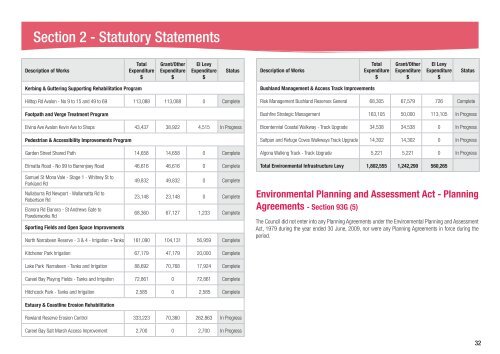
Section 2 - Statutory StatementsDescription of WorksTotalExpenditure$Grant/OtherExpenditure$EI LevyExpenditure$StatusDescription of WorksTotalExpenditure$Grant/OtherExpenditure$EI LevyExpenditure$StatusKerbing & Guttering Supporting Rehabilitation ProgramHilltop Rd Avalon - No 9 to 15 and 49 to 69 113,088 113,088 0 CompleteFootpath and Verge Treatment ProgramElvina Ave Avalon Kevin Ave to Shops 43,437 38,922 4,515 In ProgressPedestrian & Accessibility Improvements ProgramGarden Street Shared Path 14,658 14,658 0 CompleteElimatta Road - No 99 to Barrenjoey Road 46,616 46,616 0 CompleteSamuel St Mona Vale - Stage 1 - Whitney St toParkland RdNullaburra Rd Newport - Wallamatta Rd toRobertson RdElanora Rd Elanora - St Andrews Gate toPowderworks RdSporting Fields and Open Space Improvements49,832 49,832 0 Complete23,148 23,148 0 Complete68,360 67,127 1,233 CompleteNorth Narrabeen Reserve - 3 & 4 - Irrigation +Tanks 161,090 104,131 56,959 CompleteBushland Management & Access Track ImprovementsRisk Management Bushland Reserves General 68,305 67,579 726 CompleteBushfire Strategic Management 163,105 50,000 113,105 In ProgressBicentennial Coastal Walkway - Track Upgrade 34,538 34,538 0 In ProgressSaltpan and Refuge Coves Walkways Track Upgrade 14,302 14,302 0 In ProgressAlgona Walking Track - Track Upgrade 5,221 5,221 0 In ProgressTotal Environmental Infrastructure Levy 1,802,555 1,242,290 560,265Environmental Planning and Assessment Act - PlanningAgreements - Section 93G (5)The <strong>Council</strong> did not enter into any Planning Agreements under the Environmental Planning and AssessmentAct, 1979 during the year ended 30 June, 2009, nor were any Planning Agreements in force during theperiod.Kitchener Park Irrigation 67,179 47,179 20,000 CompleteLake Park Narrabeen - Tanks and Irrigation 88,692 70,768 17,924 CompleteCareel Bay Playing Fields - Tanks and Irrigation 72,861 0 72,861 CompleteHitchcock Park - Tanks and Irrigation 2,585 0 2,585 CompleteEstuary & Coastline Erosion RehabilitationRowland Reserve Erosion Control 333,223 70,360 262,863 In ProgressCareel Bay Salt Marsh Access Improvement 2,700 0 2,700 In Progress32
Section 2 - Statutory StatementsEnvironmental Programs Summary - Section 428 Part 2c (i-xi)SHOROC State of Environment <strong>Report</strong>The SHOROC region comprises the local government areas of Manly, Mosman, <strong>Pittwater</strong> and Warringah.SHOROC was launched in August 1994 and became formally incorporated in September 2006 therebyincreasing its effectiveness to advocate on behalf of the region. Its mission is to value the individuality ofmember councils while co-operating to achieve a better outcome for the community across the entire region,through networking, resource sharing, shared projects, and lobbying. Progress on projects managed by thevarious SHOROC Steering Committees is reported to the Board which meets on a regular basis.SHOROC continues to maintain and improve co-operation and resource sharing between member councilsto advocate effectively on social, economic, cultural and environmental issues and to manage sustainablegrowth so as to protect the environment and lifestyle of our local communities. SHOROC continues toconsider environmental and sustainability matters when undertaking cooperative activities, and is in theprocess of incorporating sustainability into the framework of the proposed regional strategy to ensure thatSHOROC and individual member councils are committed to sustainability outcomes in the future.A regional approach to SoE reporting has been adopted to enable the community and SHOROC to gain abetter understanding of the state of the environment, in a regional context.In this section, regional approaches are introduced and then followed by <strong>Pittwater</strong> based programs.i) LandRegional pressures on our Land and CoastlineKey pressures on the condition of the land and coastline in the region include urban development, soilcontamination, land degradation, vegetation clearing, coastal hazards such as storm damage, alteredhabitats, invasive species and bushfire.There are also a number of environmentally sensitive landscapes in the SHOROC region that constrain landuse and may increase the impact of existing pressures. For example, the region has areas with high landslippotential, relatively unstable and highly erodible soils, potential acid sulphate soils, and lands subject toflooding or coastal erosion. Climate change is anticipated to become a further significant pressure withparticular implications for the coastline, including loss of beaches, bushland and foreshore access throughincreased storm activity and sea level rise, and increased erosion activity and cliff instability.Regional response to land and coastline IssuesLand and coastline issues were addressed as part of the SHOROC SoE community consultation meetingheld on 6 August 2009. Participants in the consultation were asked to identify priority issues of concern tothem relating to land and coastline, and to work together to make recommendations for addressing theseissues. The priority land and coastline issues and recommendations are identified below:IssueSea level rise – effects/impacts on both public andprivate landLicensing (liquor licensing) ofsurf clubs – concern will theybecome ‘surf pubs’?Retaining and improvingaccess to safe horse-ridingtrails (concern about NationalPark closures forcing ridersonto highly trafficked <strong>Council</strong>roads)Impact on water quality,seagrasses and biodiversityfrom stormwater runoff.Protection of seagrass as acritical marine habitat<strong>Pittwater</strong> Programs - LandRecommendationDevelopment Control Plan- Amendment 5• Develop and implement strategies/plans to address impacts of sea levelrise and protect public/private property• Enforce a foreshore building line, and• Ensure appropriate seawalls are in place.• SHOROC to lobby State Government to put restrictions on the licensinglaws• Reopen riding trails• Construct greater linkages between trails• Undertake risk assessment and works to ensure trails are safe for horseriders/horses, and• Develop a horse-riding policy in association with horse-riders/clubs.• Undertake frequent stormwater maintenance• Develop a policy restricting stormwater entering the waterways frompublic/private property• Increase education programs on stormwater runoff and the marineenvironment• Develop an enforcement program – delivered by <strong>Council</strong> RangersThe <strong>Pittwater</strong> 21 Development Control Plan (DCP) sets the development standards, controls and regulationsthat apply when carrying out development or building work within <strong>Pittwater</strong>. It supports <strong>Pittwater</strong> LocalEnvironment Plan (1993) which regulates uses that are permissible on the land.33