download - SCAPE
download - SCAPE
download - SCAPE
- No tags were found...

Create successful ePaper yourself
Turn your PDF publications into a flip-book with our unique Google optimized e-Paper software.
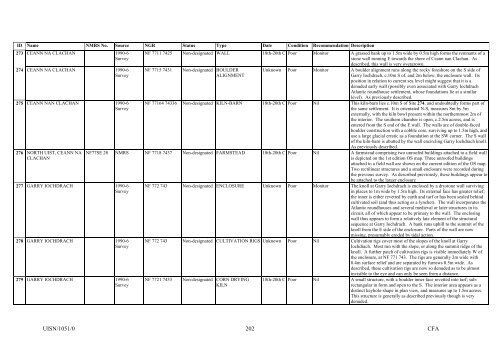
ID Name NMRS No. Source NGR Status Type Date Condition Recommendation Description273 CEANN NA CLACHAN 1990-6Survey274 CEANN NA CLACHAN 1990-6Survey275 CEANN NAN CLACHAN 1990-6Survey276 NORTH UIST, CEANN NACLACHAN277 GARRY IOCHDRACH 1990-6Survey278 GARRY IOCHDRACH 1990-6Survey279 GARRY IOCHDRACH 1990-6SurveyNF 7711 7425 Non-designated WALL 18th-20th C Poor Monitor A grassed bank up to 1.5m wide by 0.5m high forms the remnants of astone wall running E towards the shore of Ceann nan Clachan. Asdescribed, this wall is very overgrown.NF 7715 7431 Non-designated BOULDERALIGNMENTUnknown Poor Monitor A boulder alignment runs along the rocky foreshore on the S side ofGarry Iochdrach, c.10m S of, and 2m below, the enclosure wall. Itsposition in relation to current sea level might suggest that it is adenuded early wall (possibly even associated with Garry IochdrachAtlantic roundhouse settlement, whose foundations lie at a similarlevel). As previously described.NF 77164 74336 Non-designated KILN-BARN 18th-20th C Poor Nil This kiln-barn lies c.10m S of Site 274, and undoubtedly forms part ofthe same settlement. It is orientated N-S, measures 8m by 5mexternally, with the kiln bowl present within the northernmost 2m ofthe interior. The southern chamber is open, c.2.5m across, and isentered from the S end of the E wall. The walls are of double-facedboulder construction with a cobble core, surviving up to 1.5m high, anduse a large glacial erratic as a foundation at the SW corner. The S wallof the kiln-barn is abutted by the wall encircling Garry Iochdrach knoll.As previously described.NF77SE 28 NMRS NF 7718 7437 Non-designated FARMSTEAD 18th-20th C Poor Nil A farmstead comprising two unroofed buildings attached to a field wallis depicted on the 1st edition OS map. Three unroofed buildingsattached to a field wall are shown on the current edition of the OS map.Two rectilinear structures and a small enclosure were recorded duringthe previous survey. As described previously, these buildings appear tobe attached to the larger enclosureNF 772 743 Non-designated ENCLOSURE Unknown Poor Monitor The knoll at Garry Iochdrach is enclosed by a drystone wall survivingin places to 1m wide by 1.5m high. Its external face has greater relief;the inner is either revetted by earth and turf or has been sealed behindcultivated soil (and thus acting as a lynchet). The wall incorporates theAtlantic roundhouses and several medieval or later structures in itscircuit, all of which appear to be primary to the wall. The enclosingwall thus appears to form a relatively late element of the structuralsequence at Garry Iochdrach. A bank runs uphill to the summit of theknoll from the E side of the enclosure. Parts of the wall are nowmissing, presumably eroded by tidal action.NF 772 743 Non-designated CULTIVATION RIGS Unknown Poor Nil Cultivation rigs cover most of the slopes of the knoll at GarryIochdrach. Most run with the slope, or along the summit ridge of theknoll. A further patch of cultivation rigs is visible immediately W ofthe enclosure, at NF 771 743. The rigs are generally 2m wide with0.4m surface relief and are separated by furrows 0.5m wide. Asdescribed, these cultivation rigs are now so denuded as to be almostinvisible to the eye and can only be seen from a distance.NF 7721 7433 Non-designated CORN DRYINGKILN18th-20th C Poor Nil A small structure, with a boulder inner face revetted into turf; subrectangularin form and open to the S. The interior area appears as adistinct keyhole-shape in plan view, and measures up to 1.5m across.This structure is generally as described previously though is verydenuded.UISN/1051/0202CFA