download - SCAPE
download - SCAPE
download - SCAPE
- No tags were found...

Create successful ePaper yourself
Turn your PDF publications into a flip-book with our unique Google optimized e-Paper software.
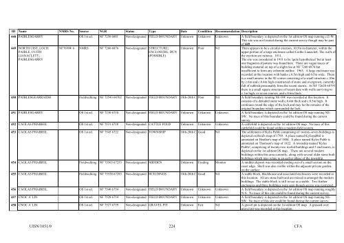
ID Name NMRS No. Source NGR Status Type Date Condition Recommendation Description448 PAIBLESGARRY OS 1st ed. NF 7250 6881 Non-designated FIELD BOUNDARY Unknown Unknown Unknown A field boundary is depicted on the 1st edition OS map running c.E-W.This site was not located during the current survey though may be partof 449.449 NORTH UIST, LOCHPAIBLE, CUITHLIANACLETT;PAIBLESGARRYNF76NW 6 NMRS NF 7260 6876 Non-designated STRUCTURE;ENCLOSURE; DUN(POSSIBLE)Unknown Poor Nil There appears to be a circular erection, 10.5m in diameter, within theupper portion of a large enclosure called Cuithe Lianaclett. The walls ofthe erection are ruinous. 1911.The site was considered in 1911 to be 'quite hypothetical' but at leastone fragment of pottery was found here. There are vague traces ofbuilding material on top of a slight rise at NF 7260 6876 butinsufficient to form any coherent outline. 1965. A large enclosure wasrecorded at this location with banks c.0.5m high and 0.5m wide. Thereis a small annexe in the SE corner consisting of a small structure c.10mby c.6m and c.0.4m high constructed of stone and overgrown, currentlyfull of rubbish presumably from the recent storms. At NF 72620 68793there is a small square structure of recent date with walls surviving toc.1m high, or seven courses, and c.0.6m thick.450 PAIBLESGEARRAIDH Fieldwalking NF 72543 68702 Non-designated FIELD BOUNDARY 18th-20th C Poor Nil A field boundary running NE-SW was recorded at this location. Itconsists of a denuded stone wall c.0.4m thick and c.0.5m high. Itcontinues round the edge of the loch and may be the remains of theoriginal boundary which surrounded the loch.451 PAIBLESGARRY OS 1st ed. NF 7230 6710 Non-designated FIELD BOUNDARY Unknown Unknown Unknown A field boundary is depicted on the 1st edition OS map running NE-SW. No trace of this boundary could be found during the currentsurvey.452 CAOLAS PHAIBEIL OS 1st ed. NF 7531 6718 Non-designated CATTLE FOLD Unknown Unknown Unknown A cattlefold is depicted on the 1st edition OS map. No trace of thiscattlefold could be found within a modern field system.453 CAOLAS PHAIBEIL OS 1st ed. NF 7545 6722 Non-designated TOWNSHIP 18th-20th C Good Nil The settlement of Kylis Pable comprising of twenty-seven buildings isdepicted on Reid's map of 1799. A place named Kylispabbil isannotated on Heather's map of 1804. A place named Kyles Pable isannotated on Thomson's map of 1822. A township named 'KylesPaible', comprising of twenty-two roofed buildings and 5 enclosures, isdepicted on the 1st edition OS map. There are several modernbuildings within this area currently, along with several older stone builtbuildings which may relate to an earlier phase of the township.454 CAOLAS PHAIBEIL Fieldwalking NF 75563 67253 Non-designated MIDDEN Unknown Eroding Monitor A midden deposit was recorded eroding out of a small section on thecoast edge. Shell was also visible within the adjacent private garden,on the surface.455 CAOLAS PHAIBEIL Fieldwalking NF 75528 67283 Non-designated BUILDINGS 18th-20th C Good Nil A stable block, blackhouse and associated enclosures were recorded atthis location. All are stone built and are mixed in amongst the modernbuildings. The stable block is still in use as a stable. Two furtherenclosures and three buildings were seen though access was restricted.456 CAOLAS PHAIBEIL OS 1st ed. NF 7540 6754 Non-designated FIELD BOUNDARY Unknown Unknown Unknown A field boundary is depicted on the 1st edition OS map running roughlyN-S. No trace of this site could be found during the current survey.457 CNOC A' LIN OS 1st ed. NF 7528 6754 Non-designated FIELD BOUNDARY Unknown Unknown Unknown A field boundary is depicted on the 1st edition OS map running NE-SW. No trace of this site could be found during the current survey.458 CNOC A' LIN OS 1st ed. NF 7527 6759 Non-designated GRAVEL PIT Unknown Fair Nil A gravel pit is depicted on the 1st edition OS map. A grassed overgravel pit was recorded at this location.UISN/1051/0224CFA