download - SCAPE
download - SCAPE
download - SCAPE
- No tags were found...

Create successful ePaper yourself
Turn your PDF publications into a flip-book with our unique Google optimized e-Paper software.
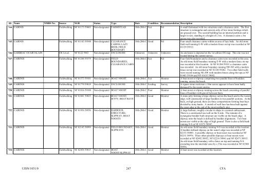
ID Name NMRS No. Source NGR Status Type Date Condition Recommendation Description744 CAIRNIS Fieldwalking NF 81173 59683 Non-designated FARMSTEAD 18th-20th C Fair Nil A small farmstead with two structures and a clearance cairn. The firststructure is rectangular and consists only of low stone footings whichare grassed over. The second building has an internal partition and islarger in size, standing to a height of c.1m. A clearance cairn c.3macross was also recorded.745 CAIRNIS Fieldwalking NF 81143 59548 Non-designated CLEARANCECAIRNS; LAZYBEDS; FIELDBOUNDARY18th-20th C Good Nil Four small clearance cairns within an area of lazy beds. An old stonefield wall running E-W with a modern fence on top was recorded at NF81129 59512.746 GARBHAC OUARTALAIN OS 1st ed. NF 8122 5943 Non-designated ENCLOSURE Unknown Unknown Unknown An enclosure is depicted on the 1st edition OS map. This site was notlocated during the current survey.747 CAIRINIS Fieldwalking NF 81248 59379 Non-designated FIELDBOUNDARIES;CLEARANCE CAIRN18th-20th C Fair Nil Four field boundaries and a clearance cairn were recorded in this area.An old stone field boundary running E-W with a modern fence on topwas recorded at this location. At NF 81284 59331 a clearance cairnwas recorded. An old stone boundary running SW-NE with a modernfence on top was recorded at NF 81330 59282. Two other field wallswere record running NE-SW with modern fences along the tops at NF81483 59184 and NF 81635 59092.748 CAIRINIS Fieldwalking NF 81573 59101 Non-designated BOAT NOOST 18th-20th C Fair Monitor A boat noost or slipway comprising two parallel lines of bouldersrunning across the beach.749 CAIRINIS Fieldwalking NF 81770 59019 Non-designated ENCLOSURE 18th-20th C Eroding Survey A square stone enclosure c.10m across appears to have been badlydamaged by the recent storms.750 CAIRINIS Fieldwalking NF 81816 59100 Non-designated BOAT NOOST 18th-20th C Poor Monitor A boat noost or slipway running across the beach consisting of parallellines of boulders with gravel between them.751 CAIRINIS Fieldwalking NF 81841 59035 Non-designated BOAT NOOST;JETTY; BOAT BAYS752 CAIRINIS Fieldwalking NF 81956 58936 Non-designated HARBOUR;STRUCTURE;SLIPWAY; BOATNOOSTS753 CAIRINIS Fieldwalking NF 82145 58999 Non-designated FIELD BOUNDARY;SLIPWAYS754 CAIRINIS Fieldwalking NF 82454 59015 Non-designated BOATNOOST/SLIPWAY18th-20th C Good Monitor A stone jetty forming a large slipway across the beach and to the watersedge, well constructed of large boulders in two parallel sections. At theback, on high ground, there are three compartments forming boat baysdivided by stony banks. A stretch of wall face has been built againstthe coast edge at the end of the most northerly pier.18th-20th C Good Monitor A large harbour, roughly circular in shape in a natural embayment.There is a constructed sea wall on the S side. The remains of arectangular boulder built structure are visible on the beach edge. Aslipway onto the beach is defined by boulder alignments. Two boatnoosts are visible at the edge of high ground There is also a field bankrunning N-S at NF 81973 58947.18th-20th C Good Monitor An old stone field boundary running N-S was recorded at this location.A boulder defined slipway on the water's edge was recorded at NF82153 58989. A possible slipway or boat noost was recorded at NF82211 58976. Three other possible slipways or boat noosts wererecorded at NF 82492 58952, NF 82216 58941 and NF 82471 58915.An old stone field boundary with a fence on top and running N-Sextending into the intertidal zone by c.35m was recorded at NF 8230058956.18th-20th C Good Monitor A boat noost was recorded at this location.UISN/1051/0247CFA