download - SCAPE
download - SCAPE
download - SCAPE
- No tags were found...
You also want an ePaper? Increase the reach of your titles
YUMPU automatically turns print PDFs into web optimized ePapers that Google loves.
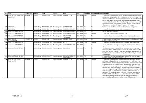
ID Name NMRS No. Source NGR Status Type Date Condition Recommendation Description709 NORTH UIST, ABHAINNNA MUILENF86SW 53 NMRS NF 8145 6161 Non-designated FARMSTEAD 18th-20th C Poor Monitor A farmstead comprising one roofed, one partially roofed building andan enclosure is depicted on the 1st edition of the OS 6-inch map. Twounroofed buildings and an enclosure are shown on the current edition ofthe OS map. Three roofless stone buildings and an enclosure wererecorded at this location. Two of the buildings survive to c.0.8m highwhereas the third is very denuded and only survives to c.0.2m high.The enclosure consists of a line of boulders c.0.5m high.710 CORUNNA Fieldwalking NF 81388 61559 Non-designated BOAT NOOST 18th-20th C Fair Nil Part of a stone-lined boat noost, now denuded and overgrown.711 CORUNNA Fieldwalking NF 81392 61571 Non-designated FIELD BOUNDARY 18th-20th C Fair Nil A stone field boundary c.0.8m high, crosses a small inlet.712 GEARRAIDH CLADACH Fieldwalking NF 81464 61413 Non-designated FIELD BOUNDARY 18th-20th C Fair Nil An old stone field boundary.713 GEARRAIDH CLADACH Fieldwalking NF 81468 61327 Non-designated FIELD BOUNDARY 18th-20th C Poor Monitor A field bank running alongside a fence, E-W.714 GEARRAIDH CLADACH Fieldwalking NF 81457 61281 Non-designated STRUCTURE 18th-20th C Fair Nil A small oval heap of stones, possibly a small structure, c.3m across.(POSSIBLE)715 NORTH UIST,BLACKHOUSENF86SW 62 NMRS NF 814 612 Non-designated RESIDENTIAL 18th-20th C Good Nil A large modern occupied house with an enclosure and at least one otherbuilding within its grounds.716 GEARRAIDH CLADACH Fieldwalking NF 81505 61142 Non-designated JETTY 18th-20th C Good Monitor A stone jetty projecting into the water of a small stony embayment.717 GEARRAIDH CLADACH Fieldwalking NF 81574 61115 Non-designated FIELD BOUNDARY 18th-20th C Fair Nil An old stone field boundary consisting of a low stony bank, running E-W.718 GEARRAIDH CLADACH Fieldwalking NF 81640 60938 Non-designated BUILDING 18th-20th C Fair Nil The denuded remains of a blackhouse consisting mostly of grassybanks though two or three courses of stone are visible in places. Onlythree sides survive. There is a field bank running E-W adjacent to theblackhouse with a modern fence on top. Rabbit burrowing is evidentacross the site.719 GEARRAIDH CLADACH Fieldwalking NF 81705 60877 Non-designated CULVERT; STONEALIGNMENT18th-20th C Fair Nil A stone culvert exiting onto the beach. A line of six or seven largeboulders visible on the beach running E-W.720 NORTH UIST, GARRY-CLADDACHNF86SW 55 NMRS NF 8184 6079 Non-designated FARMSTEAD 18th-20th C Good Monitor A farmstead comprising one unroofed, six roofed buildings and twoenclosures is depicted on the 1st edition of the OS 6-inch map. Onepartially roofed, two unroofed buildings and two enclosures are shownon the current edition of the OS map. A complex of structures andenclosures covering a large area, was recorded at this location. At leastfour buildings and two enclosures, in varying states of preservation,some surviving as footings and stony banks, others still standing to fullwallhead height. A small harbour was noted at the shore edge, NF81834 60775. It is hook-shaped with thick walls with other lines ofboulders visible on the beach. An L-shaped section of wall at NF81845 60690, projecting slightly onto the beach where it meets acurved boulder wall, may be a further extent of the harbour.UISN/1051/0244CFA


