download - SCAPE
download - SCAPE
download - SCAPE
- No tags were found...
Create successful ePaper yourself
Turn your PDF publications into a flip-book with our unique Google optimized e-Paper software.
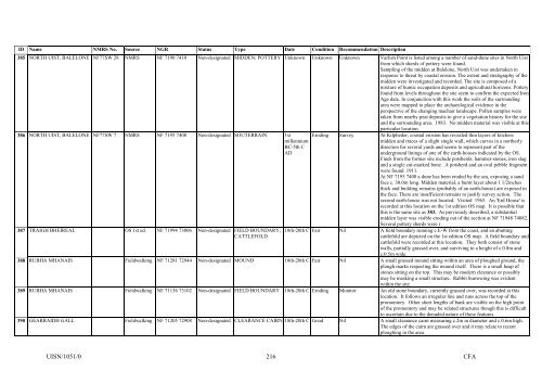
ID Name NMRS No. Source NGR Status Type Date Condition Recommendation Description385 NORTH UIST, BALELONE NF77SW 28 NMRS NF 7190 7410 Non-designated MIDDEN; POTTERY Unknown Unknown Unknown Varlish Point is listed among a number of sand-dune sites in North Uistfrom which sherds of pottery were found.Sampling of the midden at Balelone, North Uist was undertaken inresponse to threat by coastal erosion. The extent and stratigraphy of themidden were investigated and recorded. The site is composed of amixture of humic occupation deposits and agricultural horizons. Potteryfound from levels throughout the site seem to confirm the expected IronAge date. In conjunction with this work the soils of the surroundingarea were mapped to place the archaeological evidence in theperspective of the changing machair landscape. Pollen samples weretaken from nearby peat deposits to give a vegetation history for the siteand the surrounding area. 1983. No midden material was visible at thisparticular location.386 NORTH UIST, BALELONE NF77SW 7 NMRS NF 7195 7408 Non-designated SOUTERRAIN 1stmillenniumBC-5th CAD387 TRAIGH BHEIREAL OS 1st ed. NF 71994 73806 Non-designated FIELD BOUNDARY;CATTLEFOLDEroding Survey At Kilpheder, coastal erosion has revealed thin layers of kitchenmiddenand traces of a slight single wall, which curves in a northerlydirection for several yards and seems to represent part of theunderground linings of one of the earth-houses indicated by the OS.Finds from the former site include potsherds, hammer-stones, iron slagand a single cut-marked bone. A potsherd and an oval pebble fragmentwere found. 1911.At NF 7195 7408 a dune has been eroded by the sea, exposing a sandface c. 30.0m long. Midden material, a burnt layer about 1 1/2inchesthick and building remains (probably of an earth-house) are exposed inthe face. There are insufficient remains to justify survey action. Thesecond earth-house was not located. Visited 1965. An 'Erd House' isrecorded at this location on the 1st edition OS map. It is possible thatthis is the same site as 383. As previously described, a substantialmidden layer was visible eroding out of the section at NF 71948 74082.Several pottery sherds were r18th-20th C Fair Nil A field boundary running c.E-W from the coast, and an abuttingcattlefold are depicted on the 1st edition OS map. A field boundary andcattlefold were recorded at this location. They both consist of stonewalls, partially grassed over, and surviving to a height of c.0.8m andc.0.5m wide.388 RUBHA MHANAIS Fieldwalking NF 71281 72944 Non-designated MOUND 18th-20th C Fair Nil A small grassed mound sitting within an area of ploughed ground, theplough marks respecting the mound itself. There is a small heap ofstones sitting on the top. This may be modern clearance or possiblymay be masking a small structure. Rabbit burrowing was evidentwithin the site.389 RUBHA MHANAIS Fieldwalking NF 71136 73102 Non-designated FIELD BOUNDARY 18th-20th C Eroding Monitor An old stone boundary, currently grassed over, was recorded at thislocation. It follows an irregular line and runs across the top of thepromontory. Other short lengths of bank are visible on the high pointof the promontory and may be related structures though this is difficultto ascertain due to the denuded nature of these features.390 GEARRAIDH GALL Fieldwalking NF 71205 72908 Non-designated CLEARANCE CAIRN 18th-20th C Good Nil A small clearance cairn measuring c.2m in diameter and c.0.6m high.The edges of the cairn are grassed over and it may relate to recentploughing in the area.UISN/1051/0216CFA


