JTWC Report PDF - Weather Underground
JTWC Report PDF - Weather Underground
JTWC Report PDF - Weather Underground
- No tags were found...

Create successful ePaper yourself
Turn your PDF publications into a flip-book with our unique Google optimized e-Paper software.
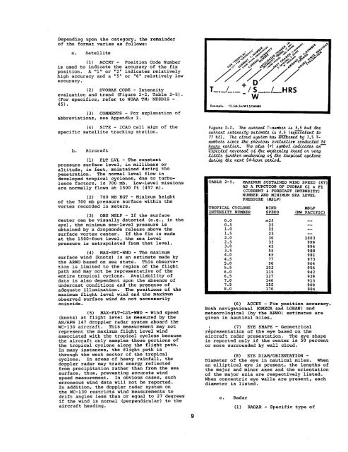
Depending upon the category, the remainderof the format varies as follows:a. Satellite(1) ACCRY - Position Code Numberis used to indicate the accuracy of the fixposition.~ ,!~,,or “ 2“ indicates relativelyhigh accuracy and a “5” or “6” relatively lowaccuracy.(2) DVORAK CODE - Intensityevaluation and trend (Figure 2-2, Table 2-5).(For specifics, refer to NOAA TM; NESDIS -45) .(3) COMMENTS - For explanation ofabbreviations, see Appendix I.E)mmpl.:T3.W4.5+1 w1.5@lms(4) SITE - ICAO call sign of thespecific satellite tracking station.b. Aircraft(1) FLT LVL - The constantpressure surface level, in millibars oraltitude, in feet, maintained durln9 thepenetration. The normal level flow indeveloped tropical cyclones, due to turbulencefactors, is 700 mb. Low-level missionsare normally flown at 1500 ft (457 m).(2) 700 MB HGT - Minimum heightof the 700 mb pressure surface within thevortex recorded in meters.(3) OBS MSLP - If the surfacecenter can be visually detected (e.g., in theeye) , the minimum sea-level Pressure isobtained by a dropsonde release above thesurface vortex center. If the fix is madeat the 1500-foot level, the sea levelpressure is extrapolated from that level.(4) MAX-SFC-WND - The maximumsurface wind (knots) is an estimate made bythe ARWO based on sea state. This observationis limited to the region of the flightpath and may not be representative of theentire tropical cyclone. Availability ofdata is also dependent upon the absence ofundercast conditions and the presence ofadequate illumination. The positions of themaximum flight level wind and the maximumobserved surface wind do not necessarilycoincide.(5) MAX-FLT-LVL-WND - Wind speed(knots) at flight level is measured by theAN/APN 147 droppler radar system aboard theWC-130 aircraft. This measurement may notrepresent the maximum flight level windassociated with the tropical cyclone becausethe aircraft only samples those portions ofthe tropical cyclone along the flight path.In many instances, the flight path isthrough the weak sector of the tropicalcyclone. In areas of heavy rainfall, thedoppler radar may track energy reflectedfrom precipitation rather than from the seasurface, thus, preventing accurate windspeed measurement. In obvious cases, sucherroneous wind data will not be reported.In addition, the doppler radar system onthe WC-130 restricts wind measurements todrift angles less than or equal to 27 degreesif the wind is normal (perpendicular) to theaircraft heading.9F@uLe 2-i?. The cuma.tT-numbm& 3.5 but.tfwCLLtwnt .in.ten.5.i,tg e&t.imRteh 4.5 Ieqiiziiatenzto77 !LtI. The ctoud h@ttWl ha w>ened bq 1.5 T-numbem &i.nm? tic pkev.ioti wztuatton cokkcted ’24how IWLL@L. The ph (+) Ayko.t inchzta an—expected fiewt.wL otj the wakening @tend oh vuy.Li.ttte @fL#IwLweakening 0{ thetmpiua.t ujd.onedwing tie next 24-hoti paiod.?ABLE 2-5.!ROPICALCYCLONE:NTENSITYNUMBER0.00.51.01.52.02.53.03.54.04.55.05.56.06.57.07.5MAXIMUM SUSTAINED WIND SPEED (lCT;AS A FUNCTION OF DVORAK CI s FI(CURRENT & FORSCAST INTENSI1’Y)NIMBER AND MINIMUM SEA LEVELPRESSURE (MSLP)WINDSPEED~2525252530354555657790102115127140155MSLP(NW PACIFIC)1003999994988981973964954942929915900(6) ACCRY - Fix position accuracy.Both navigational (OMEGA and LORAN) andmeteorological (by the ARWO) estimates aregiven in nautical miles.(7) EYE SHAPE - Geometrical‘r~presentation of the eye based on theaircraft radar presentation. The eye shapeis reported only if the center is 50 percentor more surrounded by wall cloud.(8) EyE DIAM/ORIENTATION -Diameter of the eye in nautical miles. Whenan elliptical eye is present, the lengths ofthe major and minor axes and the orientationof the major axis are respectively listed.When concentric eye walls are present, eachdiameter is listed.c. Radar(1) RADAR - Specific type of