JTWC Report PDF - Weather Underground
JTWC Report PDF - Weather Underground
JTWC Report PDF - Weather Underground
- No tags were found...

You also want an ePaper? Increase the reach of your titles
YUMPU automatically turns print PDFs into web optimized ePapers that Google loves.
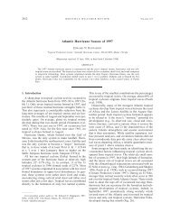
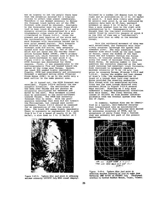
was an urgency to let the people there knowthat the potential existed for a tropicalcyclone to affect them almost immediately.Therefore it was deemed necessary to devisethe forecast track before all of the <strong>JTWC</strong>forecast aids could be obtained. Availableto the forecaster were the past fixes whichlead to best track BC on Figure 3-03-2 and asynoptic situation characterized by a midtroposphericridge north of the storm asillustrated in Figure 3-03-3. Given thepresent and past position of the storm andthe northeasterly flow across Luzon, a westwardforecast with recurvature beyond the 72hour point seemed logical. This scenariowas briefed to all concerned. When theforecast aids did arrive, they generallyagreed with this reasoning. One of the aidswhich did not agree was the One-Way InteractiveCyclone Model (OTCM), <strong>JTWC</strong>’S primaryforecast aid, which forecast Alex to move tothe north-northwest to near point D inFigure 3-03-2 in twenty-four hours. TheOTCM forecast was discounted for threereasons. First, it was perpendicular. to themid-tropospheric flow and headed toward thecenter of the ridge near Taiwan. Second,the track BCD seemed highly improbable.Finally, OTCM had consistently and erroneouslyforecast a westward moving storm (TropicalStorm Wynne (02w)) to go to the north only aweek earlier in the same general area.As it turned out, the OTCM forecast wasexcellent. Figure 3-03-4 reflects the newsynoptic situation. The anticyclone thathad been over Taiwan did not persist asoriginally anticipated but weakened andmoved to the east. This movement allowedAlex to accelerate to the north-northwesttowards Taiwan. The OTCM had correctlyforecast this to occur. With the postanalysisknowledge that Alex did not transitthe Philippines, but instead went northnorthwest,Figure 3-03-2 should be examinedfor an explanation of the true origin ofAlex. The track BCD seems highly improbableThere is currenkly no explanation for a pathfrom B to C at a speed of nearly 10 kt (19km/hr), a slow down to 3 kt (6 km/hr) at Cfollowed by a sudden 120 degree turn to theright and an acceleration to 12 kt (22 km/hr)by point D. A much more likely path wouldbe genesis near point A, as was indicated bysynoptic data back on 28 June, westwardmovement at about 5 kt (9 km/hr) to C andthen a more gradual turn to the right withacceleration to D. Consequently it is nowthought that the low-level circulationcenter found by satellite imagery at point 13on the 29th of June was a ‘red-herring”;nothing more than an eddy in the monsoontrough.Once the northward movement of Alex waswell established, the forecasts were relativelyaccurate (although the speeds weresomewhat slow) . The only question waswhether Alex would track up the east coastof Taiwan, cross the middle of the EastCnina Sea and transit through the KoreanStrait, or transfer across Taiwan, movealong the coast of mainland China and crossSouth Korea. By warning number 11 thisquestion was correctly resolved as the lasteight warnings had excellent track forecasts.Alex continued to intensify reaching amaximum intensity of 75 kt (39 m/s) justprior to crossing Taiwan (Figures 3-03-5 and3-03-6). During the middle and last phasesof Alex’s life, the southwesterlies infront of a trough that laid over centralKorea provided the steering mechanism.This trough with its associated surfacefront was the same trough observed overnorthern China in Figure 3-03-4 severaldays earlier. Starting on 5 July Alexunderwent a complex extratropical transitionwith this front. The final warning wasissued at 051200z as Alex became indistinguishablefrom the frontal system over theSea of Japan.In summary, Typhoon Alex can be identifiedas a typical, well-behaved recurverthat transitioned into an extratropicalsystern. Th& first four warnings were marredby erroneous rejection of OTCM, and byacceptance of early fixes from a featurethat was probably not part of the genesismechanism.Figtie 3-03-5. Typhoon A&x jubtptioftto atzk&.@maxi.nwn.&tW.ity (022329Z’ JULY NOAAv~ti iMU@.Y) ~F.igwle 3-03-6. Tgphoon A&x j~t ptdktiUttu.in.hlg nwi.mwn.in.tenbi.tgti ban bgzixdm &.omKaohbuiqI(wMO46744) at 022300Z July [Photogn.uphcoutttiq o~ cew%a.t wedhez Guwau, Tu.@si, T-].25