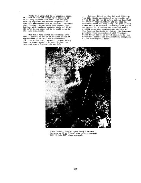
Betty was upgraded to a tropical stormat 1200Z on the Ith based upon receipt of35 kt ship reports and satellite imageryshowing improved convective organization.Aircraft reconnaissance at 080034z indicatedthat Tropical Storm Betty had intensifiedfurther with maximum surface winds of 50 kt(26 m/s) being reported in a small area inthe east semicircle.The Hong Kong Royal Observatory (WMO45005) picked up Betty on weather radar atapproximately 080300z and transmittedposition fixes until 090600Z. These hourlyreports aided greatly in positioning thetropical storm during this period.Between 0600z on the 8th and 0600Z onthe 9th, Betty maintained an intensity of50 to 55 kt (26 to 28 m/s), making landfallat 090300z approximately 135 nm (250 km)west-southwest of Hong Kong. Figure 3-04-3shows Betty at maximum intensity just priorto landfall. Dissipation occurred after091800z over the southwestern portion ofthe Peoples Republic of China. No forecastproblems were encountered with TropicalStorm Betty since it moved steadily to thenorthwest around the southwestern peripheryof the subtropical ridge.f~gwte 3-04-3. rJLQpid ~22Y0rI &.t@O.tmO,%imwnLmtm$itg oi 55 tat (2g mlbl jtif ptioz .tQ &wd@.U(090737Z Jutg v~p v~~ -GWWLY1 .29
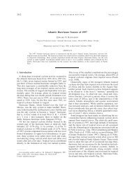
—$ v: / -f L I I I ) i I I I , , I I.A47’.-,, !4+“!! ,::.:”!!,I , (r.. .,, ,,- *+++..*l! !/::- : ,: ;OBt.- - :-A--: .--+--”TYPHOONCARYBEST TRACK TC-05W07 JULY-14 JULY 1984MAX SFC WIND 90 KTSMINIMUM SLP 955 MBSLEGENDW 06 HOUR BEST TRACK POSITA ipEED OF MOVEMENTINTENSITYPOSITION AT XX/OOOOZTROPICAL DISTURBANCETROPICAL DEPRESSIONTROPICAL STORM:tA”\ r--- ‘T’000.*.--TYPHOON23”.40+40● .* DISSIPATING22”,1~5” tie”*,,. . . . .,.. - +,~c’-+ +i““tJa\, 1 0 I1r~ ,Pf ,t ‘-”-’ t. --’5” ; t/)5a;7’ *C ,,.;: :-“’- -’””- -0- tiAKE -::,., --..“50,,- -... . . . . -,,-ta..oo5C.Iif /$. ,A:E;60 . -“501’G SPEED INTENSITYi , , , /?%jh ~,. --40/ *., -,-. A.. A+...+ . .0812Z 506- -..0s18255 . ..- -.. .- -..5“3C““”- ‘“0900Z60 ,., .-.. .- -.. ,2~B ..- -... .2~LIT,Hl-$0906260 ir.- ‘$*- ~i’::L”:u1J-YZP. - -.,.- --- -.0912z 65,KWAJO+LEINL,.. - -.. .- -., .,.. ...,0918z 75IALAU IS a a1,- -.. WOLEfi - ““”F-2NAPE1000Z 90.- .,. , .- -.. -.. ..,. ...11006z 90, , ,i , 1KOSRAE2- . . . . .- -.. ,,,, ,,’ .,. .10I2Z 805,, . . ..,. . .- -.. . ,. . . . . .- .,,,1018z 757. . +;;:,.- -,. , .- -.. . .,,. ...,11OOZ 70,::: :6I t t , , II + I , t 1 t I , @RI ‘ .-aSUPER TYPHOON STARTSUPER TYPHOON ENDEXTRATROPICALSTAGEFIRST WARNING ISSUEDLAST WARNING ISSUED1 1 I [ ! I 1 , I , .,, r , 1 1.TRUK . -. ,.. . . . . . . . . ,4, .MAJURO. . . . . . .D TARA,,, - -.. .- ... . .- -,,”. ..,. ,..’ ... ---- w .“ _YF-T#dTIt
- Page 1 and 2: 1984ANNUAL TROPICALi CYCLONEREPORT1
- Page 3 and 4: U,S, NAVAL OCEANOGRAPHY COMMAND CEN
- Page 5 and 6: FOREWARDThe Annual Tropical Cyclone
- Page 7 and 8: CHAPTER VAPPLIED TROPICAL CYCLONE R
- Page 9 and 10: outes the large volume of meteorolo
- Page 11 and 12: 8. PROGNOSTIC REASONING MESSAGESFor
- Page 13 and 14: 4.SATELLITE RECONNAISSANCE SUMMARYT
- Page 15 and 16: TABLE 2-4. FIX PLATFORN SUNNARY FOR
- Page 17 and 18: platform (land, aircraft, or ship)
- Page 19 and 20: TABLE 3-2.1984 SIGNIFICANT TROPICAL
- Page 21 and 22: +-s+ +n‘1” L’1 . 1’ .!”.h
- Page 23 and 24: t-iilI ,’+“ 3’++ , +*2Itillml
- Page 25 and 26: ,. -.. ..- .,. ,.-...- ... ., ,.,-
- Page 27 and 28: F@#LIZ 3-02-2. Wgnneab a 50 kt (26
- Page 29 and 30: .-TYPHOONALEXBEST TRACK TC-03W -01
- Page 31 and 32: F@Uu? 3-03-3. Akd-tt.opobph&c ff&W
- Page 33 and 34: ,., . 1 -.. :..,, . /d.. :,, .. . -
- Page 35: Aircraft reconnaissance flights on
- Page 39 and 40: Between 0000Z on the 9th and 1200z
- Page 41 and 42: 0[CJ3ilSSl ONINilVM lSV1 ~a3flSSl !
- Page 43 and 44: i’nthe northwest quadrant of Dina
- Page 45 and 46: ,!!1,,,,1,TYPHOONEDBEST TRACK TC-07
- Page 48 and 49: TROPICA.LSTORM FREDA(08w)Tropical S
- Page 50 and 51: F.igum 3-08-3. Tz.Op.id .$tozm FJLe
- Page 52 and 53: TROPICAL DEPRESSION(09W)Tropical De
- Page 54: TROPICAL STORM GERALD(1OW)Tropical
- Page 57 and 58: !,, ,, ,,, ,, ,,TYPHOONHOLLYBEST TR
- Page 59: Figure 3-ii-2 shows the wind fIeIda
- Page 62: TROPICAL DEPRESSION(12W)Tropical De
- Page 65 and 66: t“1’””# IL”a3nssl s3NINUV
- Page 67 and 68: This change in track was due to the
- Page 69 and 70: ..——w.,.. - . . .- -., . . L! .
- Page 71 and 72: At the time of the first warning,Tr
- Page 73 and 74: k’ 125° 130” 135° 140° 145
- Page 75 and 76: Fi.gLuLe3-15-2. /ii.d--!CV& tipObpk
- Page 77 and 78: ,..‘“!::$:”:::b::t::t:::h.:7P
- Page 80 and 81: TROPICAJ_ISTORM MAURY(17W)During a
- Page 82 and 83: At 301200z, Maury was approximately
- Page 84 and 85: TROPICALSTORN NINA(18W)Tropical Sto
- Page 86 and 87:
Between 3006002 and 3018002, the lo
- Page 88 and 89:
TYPHOON OGDEN(19W)Typhoon Ogden was
- Page 90 and 91:
The ARWO also verified that extratr
- Page 92 and 93:
TYPHOON PHYLLIS(20W)Typhoon Phyllis
- Page 94 and 95:
As Phyllis passed north of 25N, the
- Page 96 and 97:
TROPICAL STORM ROY (21W)Tropical St
- Page 98 and 99:
As it turned out, these would be th
- Page 100 and 101:
TROPICAL STORM SUSAN (22W)Tropical
- Page 102 and 103:
transited up the Mekong Valley. Eve
- Page 104 and 105:
TROPICAL DEPRESSION(23W)Tropical De
- Page 106 and 107:
TYPHOON THAI) (24W)Typhoon Thad dev
- Page 108 and 109:
(a)(c)F.igtie3-24-2. Th.tte view o~
- Page 110 and 111:
SUPER TYPHOON VANESSA(25W)Super Typ
- Page 112 and 113:
The only significant damage on Guam
- Page 114 and 115:
TYPHOON WARREN(26W)Typhoon Warren w
- Page 116 and 117:
Other coastal areas and marineinter
- Page 118 and 119:
TYPHOQN AGNES(27w)Typhoon Agnes was
- Page 120 and 121:
Figuze 3-27-2. TyphoonAgnebat 100kZ
- Page 122 and 123:
18*+x+++\,,+++%+ \+ + +++\+X-* . ,+
- Page 124 and 125:
forecast to pass less than 30 nrn (
- Page 126 and 127:
F.igoAe3-2g-4. i3W emt od Luzonab i
- Page 128:
Figuzt 3-2~-7. Tgphoon C.&zIUZ acee
- Page 131 and 132:
From this point on, Clara was a wel
- Page 133 and 134:
ii‘:,;f’-(-$!l$j*; ,;~~:, ..,..
- Page 135 and 136:
convection near the center of the d
- Page 137 and 138:
2. NORTH INDIAN OCEAN TROPICAL CYCL
- Page 140 and 141:
40” 45°30”coJO 55°60” 65°
- Page 142 and 143:
~o..~GjO‘5°Jo 55° 60° 65° 70
- Page 144 and 145:
(9 L-Z M3N) 29/000” 05+3 .06.% I
- Page 146 and 147:
Since Tropical Cyclone 03B was firm
- Page 148 and 149:
DTG2806Z2812z2818Z2900Z2906Z2912Z29
- Page 150 and 151:
During the next 48 hours, TropicalC
- Page 152 and 153:
10NAUTICAL MILE ERROR9Figure4-2aI,I
- Page 154 and 155:
ANNUAL MEAN FORECAST ERRORS (NM) FO
- Page 156 and 157:
“b.North Indian OceanThe position
- Page 158 and 159:
2. COMPARISON OF OBJECTWE TECHNIQUE
- Page 160 and 161:
= 492 317227 0m459 215 472 L602.283
- Page 162 and 163:
CHAPTER V - APPLIED TROPICAL CYCLON
- Page 164 and 165:
TROPICAL CYCLONE READINESS CONDITIO
- Page 166 and 167:
xss7 TRncK WIRNINGPOSIT,?0,5 135.12
- Page 168 and 169:
EEElBEST TRACK UhRNING 24 HOUR FO!?
- Page 170 and 171:
POS 1714.7 1Z6.314.5 1z5, L314.6 12
- Page 172 and 173:
TVPHOON CARYBEST TRRCK D6TA*LL F~qm
- Page 174 and 175:
BESTTRI? CKPOS1 T21,0 162,2Z1.0 161
- Page 176 and 177:
BEST TRACK WM?NINGPOSIT28 0 13s,127
- Page 178 and 179:
;:; 311700 32.8N 120.7E LIIND3es4 i
- Page 180 and 181:
FILL FORECRSTSURNG $;&R ~~;:R 72;:R
- Page 182 and 183:
fil RcRfiFT FIXESF1!:POSITIONFLTL V
- Page 184 and 185:
+ ++++++ ++++++++++++- . . . . . .
- Page 186 and 187:
BESTTRA(POSIT19.1 142.719,5 141.819
- Page 188 and 189:
56:;5.960616e63x :;6667686970x 7;73
- Page 190 and 191:
MO/DR/HR0828ee2e8&!806z082812208281
- Page 192 and 193:
BEST TRflCK IJARNINGPOSIT18,6 115.7
- Page 194 and 195:
EEEiiElBEST TROCK URRNING 24 HOUR F
- Page 196 and 197:
EiElBEST TRRCK WQRNINGPOSIT WIND PO
- Page 198 and 199:
BEsr 7RIICK UC+RNING 24 HOuR F0REc~
- Page 200 and 201:
OEST TRFICK IWRNINGPOSIT8.7 1s0,19.
- Page 202 and 203:
75;;z:80al828384858887::9091::94;29
- Page 204 and 205:
6465666768697071x ;;757677767960818
- Page 206 and 207:
%67::;;7.273747s7677787980818283848
- Page 208 and 209:
.-..,..-=.- ..7 .PCN 3PCN 4PCN 3PCN
- Page 210 and 211:
EEiEilBEST TRQCK WI%RNINGPOSIT5.4 1
- Page 212 and 213:
8EST TR.4 CKUfiRNING24 HOUR FORECeS
- Page 214 and 215:
2. NORTH INDIAN OCEAN CYCLONEBEST T
- Page 216 and 217:
~&WQ&~R1 10s062i10912z1109I8Zl11000
- Page 218 and 219:
e3L3609@311040311@5031339e317@90323
- Page 220 and 221:
NEPRFNESSNaval Environmental Predic
- Page 222 and 223:
APPENDIXIllNAMES FOR TROPICAL CYCLO
- Page 224 and 225:
APPENDIXPAST ANNUAL TROPICAL CYCLON
- Page 226 and 227:
UNCLASSIFIED;ECURITY CLASSIFICATION
- Page 228:
w*Taopicd Cydlone 30S (KarniAg) on