JTWC Report PDF - Weather Underground
JTWC Report PDF - Weather Underground
JTWC Report PDF - Weather Underground
- No tags were found...

Create successful ePaper yourself
Turn your PDF publications into a flip-book with our unique Google optimized e-Paper software.
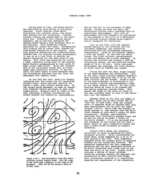
TYPHOON DINAH(06W)During much of July, the North Pacificwas dominated by slow moving or stationaryfeatures. After Tropical Storm Bettydissipated over southern China, the southwestmonsoon did not re-develop. Instead,surface ridging was established in the SouthChina Sea, Gradually this ridging spreadeastward, and by mid-July dominated thewestern North Pacific from Southeast Asia tothe dateline. This anomalous ridgi”ngpersisted fox almost two weeks. Accompanyingthis ridging was an almost total absence ofsignificant convection in the tropics. Withhigh pressure dominating the climatologicallyfavored area for tropical cyclone development,it was up to a cold front to provide thegenesis mechanism for the next storm of theseason. This front had persisted for nearlya week, extending across much of the centralNorth Pacific southwestward to just north ofWake Island (WMO 91245). while the southernend of the associated trough had, at times,shown some convective activity, it was notuntil the front began to move eastward thatthe disturbance detached from the front anddeveloped into Typhoon Dinah.On the 20th and 21st, satellite imageryindicated that the trough and its associatedsurface front, which had been inactive fornearly a week, were finally moving east. Asthe trough moved eastward, an area of convectionremained behind and began to show someorganization. Synoptic data at 12002 on the21st indicated a surface circulation hadformed beneath the convection, approximatelyFi.guae 3-06-1. Mid-lx.oPobPh&cuind &OU) which. . .~q btetned Typhoon Dinah. Note the z.i.dgetoto.~tth d.th a tintib .intlrz tidge to the[FNOC 400 tnb NVA tiyb.i6 vdi.d at251200Z JuLYI.300 nm (556 km) to the northwest of WakeIsland. During the next two days, thedisturbance drifted slowly westward with nosignificant development. This lack ofdevelopment and slow movement are attributedto the passage to the north of a developingmid-latitude frontal system which significantlyelongated the convection.Late on the 23rdr with the frontalsystem passing to the northeast and itsinfluence lessening, the convectionassociated with the disturbance increasedconsiderably. Based on the 2400002 imagery,a TCFA was issued. As the TCFA was beingissued, the first aircraft reconnaissanceof the disturbance was already underway. By2402502 the aircraft had located a 1000 mbcirculation center, and had observed surfacewinds of 30 kt (15 m/s). Since continueddevelopment was expected, the first warningon Dinah valid at 2406002 was issued.During the next two days, Dinah trackedto the west-southwest and intensified. Lateon the 25th, Dinah attained typhoon intensitywith aircraft reporting that a 30 nm (56 km)wide circular eye had formed. Dinah’s trackto the west-southwest is attributed to theflow around a narrow mid-tropospheric ridgeto its north (Figure 3-06-1). At this time,Tropical Storm Ed (soon to be Typhoon Ed)was moving southeast towards Dinah. Thiscaused the ridge to the north to slide tothe east allowing Dinah to turn to the northwestinto the weakness.Between 00002 on the 26th and OOOOZ onthe 28th, Dinah and Ed were within 900 nm(1667 km) of each other, wi’@ the closestpoint of approach being at 2621OOZ when theywere approximately 630 nm (1167 km) apart(Figure 3-06-2). While <strong>JTWC</strong> was warning onthese systems it was thought that the majortrack changes to both were a result of theirinteraction. However, post-analysisindicates this interaction between Dinah andEd was not nearly as great a factor asinitially thought. It is now believed thatthe proximity of the storms did not have amajor affect on their respective tracks andonly a short-lived influence on Dinahisintensity.Figure 3-06-3 shows the intensityvariations of Dinah as measured by reconnaissanceaircraft. After intensifying forthree days, Dinah weakened for a 12 to 24hour period on the 27th. This weakeninghappened after the closest point of approachbetween the two storms had occurred. Themechanism responsible for this temporaryweakening was the well developed outflow ofEd which interacted with Dinah late on the26th and early on the 27th. Figure 3-06-4contains a series of three infraredsatellite pictures shcwing the approach andinteraction of Ed’s outflow with Dinah.This interaction resulted in a significantshearing and suppression of the convection35