- Page 1 and 2:
1984ANNUAL TROPICALi CYCLONEREPORT1
- Page 3 and 4:
U,S, NAVAL OCEANOGRAPHY COMMAND CEN
- Page 5 and 6:
FOREWARDThe Annual Tropical Cyclone
- Page 7 and 8:
CHAPTER VAPPLIED TROPICAL CYCLONE R
- Page 9 and 10:
outes the large volume of meteorolo
- Page 11 and 12:
8. PROGNOSTIC REASONING MESSAGESFor
- Page 13 and 14:
4.SATELLITE RECONNAISSANCE SUMMARYT
- Page 15 and 16:
TABLE 2-4. FIX PLATFORN SUNNARY FOR
- Page 17 and 18:
platform (land, aircraft, or ship)
- Page 19 and 20:
TABLE 3-2.1984 SIGNIFICANT TROPICAL
- Page 21 and 22:
+-s+ +n‘1” L’1 . 1’ .!”.h
- Page 23 and 24:
t-iilI ,’+“ 3’++ , +*2Itillml
- Page 25 and 26:
,. -.. ..- .,. ,.-...- ... ., ,.,-
- Page 27 and 28:
F@#LIZ 3-02-2. Wgnneab a 50 kt (26
- Page 29 and 30:
.-TYPHOONALEXBEST TRACK TC-03W -01
- Page 31 and 32:
F@Uu? 3-03-3. Akd-tt.opobph&c ff&W
- Page 33 and 34:
,., . 1 -.. :..,, . /d.. :,, .. . -
- Page 35 and 36:
Aircraft reconnaissance flights on
- Page 37 and 38:
—$ v: / -f L I I I ) i I I I , ,
- Page 39 and 40:
Between 0000Z on the 9th and 1200z
- Page 41 and 42:
0[CJ3ilSSl ONINilVM lSV1 ~a3flSSl !
- Page 43 and 44:
i’nthe northwest quadrant of Dina
- Page 45 and 46:
,!!1,,,,1,TYPHOONEDBEST TRACK TC-07
- Page 48 and 49:
TROPICA.LSTORM FREDA(08w)Tropical S
- Page 50 and 51:
F.igum 3-08-3. Tz.Op.id .$tozm FJLe
- Page 52 and 53:
TROPICAL DEPRESSION(09W)Tropical De
- Page 54:
TROPICAL STORM GERALD(1OW)Tropical
- Page 57 and 58:
!,, ,, ,,, ,, ,,TYPHOONHOLLYBEST TR
- Page 59:
Figure 3-ii-2 shows the wind fIeIda
- Page 62:
TROPICAL DEPRESSION(12W)Tropical De
- Page 65 and 66:
t“1’””# IL”a3nssl s3NINUV
- Page 67 and 68:
This change in track was due to the
- Page 69 and 70:
..——w.,.. - . . .- -., . . L! .
- Page 71 and 72:
At the time of the first warning,Tr
- Page 73 and 74:
k’ 125° 130” 135° 140° 145
- Page 75 and 76:
Fi.gLuLe3-15-2. /ii.d--!CV& tipObpk
- Page 77 and 78:
,..‘“!::$:”:::b::t::t:::h.:7P
- Page 80 and 81:
TROPICAJ_ISTORM MAURY(17W)During a
- Page 82 and 83:
At 301200z, Maury was approximately
- Page 84 and 85:
TROPICALSTORN NINA(18W)Tropical Sto
- Page 86 and 87:
Between 3006002 and 3018002, the lo
- Page 88 and 89:
TYPHOON OGDEN(19W)Typhoon Ogden was
- Page 90 and 91:
The ARWO also verified that extratr
- Page 92 and 93:
TYPHOON PHYLLIS(20W)Typhoon Phyllis
- Page 94 and 95:
As Phyllis passed north of 25N, the
- Page 96 and 97:
TROPICAL STORM ROY (21W)Tropical St
- Page 98 and 99:
As it turned out, these would be th
- Page 100 and 101:
TROPICAL STORM SUSAN (22W)Tropical
- Page 102 and 103:
transited up the Mekong Valley. Eve
- Page 104 and 105:
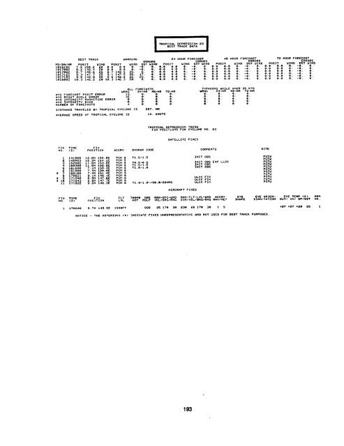
TROPICAL DEPRESSION(23W)Tropical De
- Page 106 and 107:
TYPHOON THAI) (24W)Typhoon Thad dev
- Page 108 and 109:
(a)(c)F.igtie3-24-2. Th.tte view o~
- Page 110 and 111:
SUPER TYPHOON VANESSA(25W)Super Typ
- Page 112 and 113:
The only significant damage on Guam
- Page 114 and 115:
TYPHOON WARREN(26W)Typhoon Warren w
- Page 116 and 117:
Other coastal areas and marineinter
- Page 118 and 119:
TYPHOQN AGNES(27w)Typhoon Agnes was
- Page 120 and 121:
Figuze 3-27-2. TyphoonAgnebat 100kZ
- Page 122 and 123:
18*+x+++\,,+++%+ \+ + +++\+X-* . ,+
- Page 124 and 125:
forecast to pass less than 30 nrn (
- Page 126 and 127:
F.igoAe3-2g-4. i3W emt od Luzonab i
- Page 128:
Figuzt 3-2~-7. Tgphoon C.&zIUZ acee
- Page 131 and 132:
From this point on, Clara was a wel
- Page 133 and 134:
ii‘:,;f’-(-$!l$j*; ,;~~:, ..,..
- Page 135 and 136:
convection near the center of the d
- Page 137 and 138:
2. NORTH INDIAN OCEAN TROPICAL CYCL
- Page 140 and 141:
40” 45°30”coJO 55°60” 65°
- Page 142 and 143:
~o..~GjO‘5°Jo 55° 60° 65° 70
- Page 144 and 145:
(9 L-Z M3N) 29/000” 05+3 .06.% I
- Page 146 and 147:
Since Tropical Cyclone 03B was firm
- Page 148 and 149: DTG2806Z2812z2818Z2900Z2906Z2912Z29
- Page 150 and 151: During the next 48 hours, TropicalC
- Page 152 and 153: 10NAUTICAL MILE ERROR9Figure4-2aI,I
- Page 154 and 155: ANNUAL MEAN FORECAST ERRORS (NM) FO
- Page 156 and 157: “b.North Indian OceanThe position
- Page 158 and 159: 2. COMPARISON OF OBJECTWE TECHNIQUE
- Page 160 and 161: = 492 317227 0m459 215 472 L602.283
- Page 162 and 163: CHAPTER V - APPLIED TROPICAL CYCLON
- Page 164 and 165: TROPICAL CYCLONE READINESS CONDITIO
- Page 166 and 167: xss7 TRncK WIRNINGPOSIT,?0,5 135.12
- Page 168 and 169: EEElBEST TRACK UhRNING 24 HOUR FO!?
- Page 170 and 171: POS 1714.7 1Z6.314.5 1z5, L314.6 12
- Page 172 and 173: TVPHOON CARYBEST TRRCK D6TA*LL F~qm
- Page 174 and 175: BESTTRI? CKPOS1 T21,0 162,2Z1.0 161
- Page 176 and 177: BEST TRACK WM?NINGPOSIT28 0 13s,127
- Page 178 and 179: ;:; 311700 32.8N 120.7E LIIND3es4 i
- Page 180 and 181: FILL FORECRSTSURNG $;&R ~~;:R 72;:R
- Page 182 and 183: fil RcRfiFT FIXESF1!:POSITIONFLTL V
- Page 184 and 185: + ++++++ ++++++++++++- . . . . . .
- Page 186 and 187: BESTTRA(POSIT19.1 142.719,5 141.819
- Page 188 and 189: 56:;5.960616e63x :;6667686970x 7;73
- Page 190 and 191: MO/DR/HR0828ee2e8&!806z082812208281
- Page 192 and 193: BEST TRflCK IJARNINGPOSIT18,6 115.7
- Page 194 and 195: EEEiiElBEST TROCK URRNING 24 HOUR F
- Page 196 and 197: EiElBEST TRRCK WQRNINGPOSIT WIND PO
- Page 200 and 201: OEST TRFICK IWRNINGPOSIT8.7 1s0,19.
- Page 202 and 203: 75;;z:80al828384858887::9091::94;29
- Page 204 and 205: 6465666768697071x ;;757677767960818
- Page 206 and 207: %67::;;7.273747s7677787980818283848
- Page 208 and 209: .-..,..-=.- ..7 .PCN 3PCN 4PCN 3PCN
- Page 210 and 211: EEiEilBEST TRQCK WI%RNINGPOSIT5.4 1
- Page 212 and 213: 8EST TR.4 CKUfiRNING24 HOUR FORECeS
- Page 214 and 215: 2. NORTH INDIAN OCEAN CYCLONEBEST T
- Page 216 and 217: ~&WQ&~R1 10s062i10912z1109I8Zl11000
- Page 218 and 219: e3L3609@311040311@5031339e317@90323
- Page 220 and 221: NEPRFNESSNaval Environmental Predic
- Page 222 and 223: APPENDIXIllNAMES FOR TROPICAL CYCLO
- Page 224 and 225: APPENDIXPAST ANNUAL TROPICAL CYCLON
- Page 226 and 227: UNCLASSIFIED;ECURITY CLASSIFICATION
- Page 228: w*Taopicd Cydlone 30S (KarniAg) on