JTWC Report PDF - Weather Underground
JTWC Report PDF - Weather Underground
JTWC Report PDF - Weather Underground
- No tags were found...

Create successful ePaper yourself
Turn your PDF publications into a flip-book with our unique Google optimized e-Paper software.
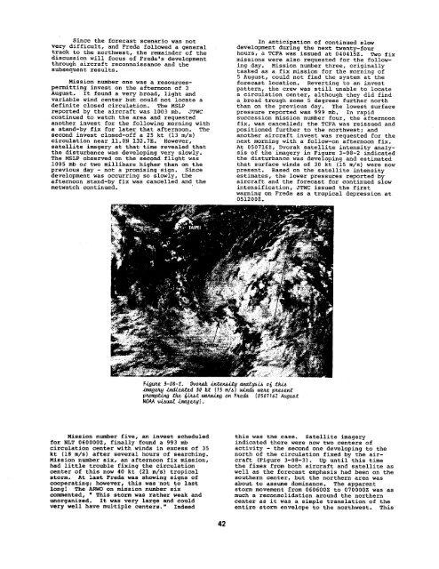
Since the forecast scenario was not In anticipation of continued slowvery difficult, and Freda followed a general development during the next twenty-fourtrack to the northwest, the remainder of the hours, a TCFA was issued at 040415Z. Two fixdiscussion will focus of Freda’s developmentmissions were also requested for the followingday. Mission number three, originallythrough aircraft reconnaissance and thesubsequent results.tasked as a fix mission for the morning of5 August, could not find the system at theMission number one was a resources- forecast location. Reverting to an investpermitting invest on the afternoon of 3 pattern, the crew was still unable to locateAugust.. It found a very broad, light and a circulation center, although they did findvariable wind center but could not locate aa broad trough some 5 degrees further northdefinite closed circulation. The MSLP than on the previous day. The lowest surfacereported by the aircraft was 1003 mb. <strong>JTWC</strong> pressure reported was 999 ti. In rapidcontinued to watch the area and requested succession mission number four, the afternoonanother invest for the following morning with fix, was cancelled; the TCFA was reissued anda stand-by fix for later that afternoon. The positioned further to the northwest; andsecond invest closed-off a 25 kt (13 m/s) another aircraft invest was requested for thecirculation near 11.ON 132.7E. However, next morning with a follow-on afternoon fix.satellite imagery at that time revealed that At 050716Z, Dvorak satellite intensity analythedisturbance was developing very slowly. sis of the imagery in Figure 3-08-2 indicatedThe t.lSLPobserved on the second flight was the disturbance was developing and estimated1005 mb or two millibars higher than on the that surface winds of 30 kt (15 m/s) were nowprevious day - not a promising sign. Since present. Based on the satellite intensitydevelopment was occurring so slowly, the estimates, the lower pressures reported byafternoon stand-by fix was cancelled and the aircraft and the forecast for continued slowmetwatch continued. intensification, <strong>JTWC</strong> issued the firstwarning on Freda as a tropical depression at0512002.Figr,uu?3-08-2. vuotakA1.ten&Ltyan@@& 06 .th.itl@CVLY Stied 30 k-t (1s ml~) ukndA watt pmaetiphompting the @bt w@uting on Fae& [050716Z AuguA.tNOAAvi-wa.ti.nagtq].Mission number five, an invest scheduledfor NLT 0600002, finally found a 993 mbcirculation center with winds in excess of 35kt (18 m/s) after several hours of searching.Mission number six, an afternoon fix mission,had little trouble fixing the circulationcenter of this now 40 kt (21 m/s) tropicalstorm. At last Preda was showing signs ofcooperating; however, this was ‘not to lastlong ! The ARWO on mission number sixcommented, m This storm was rather weak andunorganized. It was very large and couldvery well have multiple centers.” Indeedthis was the case. Satellite imageryindicated there were now two centers ofactivity - the second one developing to thenorth of the circulation fixed by the aircraft(Figure 3-08-3). Up UrWil this timethe fixes from both aircraft and satellite aswell as the forecast emphasis had been on thesouthern center, but the northern area wasabout to assume dominance. The apparentstorm movement from 060600Z to 070000Z was asmuch a reconsolidation around the northerncenter as it was a simple translation of theentire storm envelope to the northwest. This42