JTWC Report PDF - Weather Underground
JTWC Report PDF - Weather Underground
JTWC Report PDF - Weather Underground
- No tags were found...

Create successful ePaper yourself
Turn your PDF publications into a flip-book with our unique Google optimized e-Paper software.
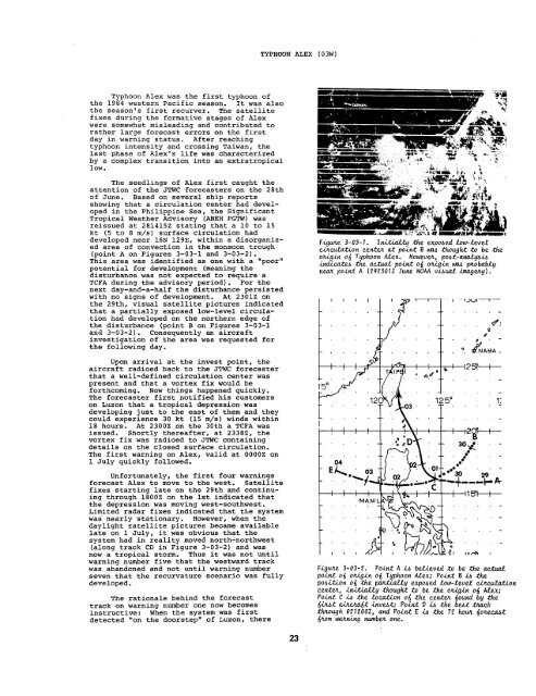
TYPHOON ALEX(03W)Typhoon Alex was the first typhoon ofthe 1984 western Pacific season. It was alsothe season’s first recurver. The satellitefixes during the formative stages of Alexwere somewhat misleading and contributed torather large forecast errors on the firstday in warning status. After reachingtyphoon intensity and crossing Taiwanr thelast phase of Alex’s life was characterizedby a complex transition into an extratropicallow.The seedlings of Alex first caught theattention of the <strong>JTWC</strong> forecasters on the 28thof June. Based on several ship reportsshowing that a circulation center had developedin the Philippine Sea, the SignificantTropical <strong>Weather</strong> Advisory (ABEH PGTW) wasreissued at 281415Z stating that a 10 to 15kt (5 to 8 m/s) surface circulation haddeveloped near 16N 129E, within a disorganizedarea of convection in the monsoon trough(point A on Figures 3-03-1 and 3-03-2).This area was identified as one with a “poor”potential for development (meaning thedisturbance was not expected to require aTCFA during the advisory period). For thenext day-and-a-half the disturbance persistedwith no signs of development. At 2301z onthe 29th, visual satellite pictures indicatedthat a partially exposed low-level circulationhad developed on the northern edge ofthe disturbance (point B on Figures 3-03-1and 3-03-2). Consequently an aircraftinvestigation of the area was requested forthe following day.F.igum3-03-1. Initiallythe expohtd ho-leve.tc.ikculation centezat pointE w though a% be -theotigin od Typhoon M3ex. floweuu, pobt-ana.tyA.iAindititi the actual! point 06 otig.in WA ptobablyneat point A (292301Z June NOAAv.dti .iknagekq).Upon arrival at the invest point, theaircraft radioed back to the <strong>JTWC</strong> forecasterthat a well-defined circulation center waspresent and that a vortex fix would beforthcoming. NOW things happened quickly.The forecaster first notified his customerson Luzon that a tropical depression wasdeveloping just to the east of them and theycould experience 30 kt (15 m/s) winds within18 hours. At 2300Z on the 30th a TCFA wasissued. Shortly thereafter, at 2338Z, thevortex fix was radioed to <strong>JTWC</strong> containingdetails on the closed surface circulation.The first warning on Alex, valid at 0000Z on1 July quickly followed.Unfortunately, the first four warningsforecast Alex to move to the west. Satellitefixes starting late on the 29th and continuingthrough 1800z on the 1st indicated thatthe depression was moving west-southwest.Limited radar fixes indicated that the systemwas nearly stationary. However, when thedaylight satellite pictures became availablelate on 1 July, it was obvious that thesystem had in reality moved north-northwest(along track CD in Figure 3-03-2) and wasnow a tropical storm. Thus it was not untilwarning number five that the westward trackwas abandoned and not umtil warning numberseven that the recurvature scenario was fullydeveloped.The rationale behind the forecasttrack on warning number one now becomesinstructive: When the system was firstdetected “on the doorstep” of Luzon, thereFiguze3-03-2. PointA h bet,ieved to be the aetua.tpoint o~ otig.ino{ Typhoon /&ex; ?oiti B h thepo~i.tion o{ the pattially expohed tow-.teud c.&e&z& ‘oncenakt, .initia.Uy thought to be the om.in o~ ALex;Point C .iA the .2maXion 06 the ceticz iound by theIfiJIAz a.&.c)@tinvtit; Po&tV. i A the btiftich.tktough 021200Z,and Point E .iA the 72 ho#L ~oaeeabt@om uwtningnumbtione.23