

Storm Data and Unusual Weather Phenomena - CIG
Storm Data and Unusual Weather Phenomena - CIG
Storm Data and Unusual Weather Phenomena - CIG
- No tags were found...

Create successful ePaper yourself
Turn your PDF publications into a flip-book with our unique Google optimized e-Paper software.
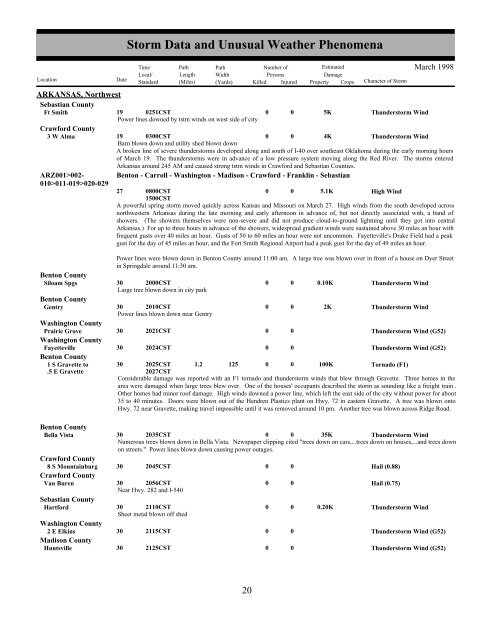
ARKANSAS, NorthwestSebastian CountyFt Smith19 0251CSTPower lines downed by tstm winds on west side of cityCrawford County3 W Alma 19 0300CSTBarn blown down <strong>and</strong> utility shed blown downARZ001>002-010>011-019>020-02900005K4KThunderstorm WindThunderstorm WindA broken line of severe thunderstorms developed along <strong>and</strong> south of I-40 over southeast Oklahoma during the early morning hoursof March 19. The thunderstorms were in advance of a low pressure system moving along the Red River. The storms enteredArkansas around 245 AM <strong>and</strong> caused strong tstm winds in Crawford <strong>and</strong> Sebastian Counties.Benton - Carroll - Washington - Madison - Crawford - Franklin - Sebastian27 0800CST0 0 5.1KHigh Wind1500CSTA powerful spring storm moved quickly across Kansas <strong>and</strong> Missouri on March 27. High winds from the south developed acrossnorthwestern Arkansas during the late morning <strong>and</strong> early afternoon in advance of, but not directly associated with, a b<strong>and</strong> ofshowers. (The showers themselves were non-severe <strong>and</strong> did not produce cloud-to-ground lightning until they got into centralArkansas.) For up to three hours in advance of the showers, widespread gradient winds were sustained above 30 miles an hour withfrequent gusts over 40 miles an hour. Gusts of 50 to 60 miles an hour were not uncommon. Fayetteville's Drake Field had a peakgust for the day of 45 miles an hour, <strong>and</strong> the Fort Smith Regional Airport had a peak gust for the day of 49 miles an hour.Power lines were blown down in Benton County around 11:00 am. A large tree was blown over in front of a house on Dyer Streetin Springdale around 11:30 am.Benton CountySiloam Spgs30 2000CST0 0 0.10KThunderstorm WindLarge tree blown down in city parkBenton CountyGentry30 2010CST0 0 2KThunderstorm WindPower lines blown down near GentryWashington CountyPrairie Grove30 2021CST0 0Thunderstorm Wind (G52)Washington CountyFayetteville30 2024CST0 0Thunderstorm Wind (G52)Benton County1 S Gravette to 30 2025CST 1.2 125 0 0 100KTornado (F1).5 E Gravette2027CSTConsiderable damage was reported with an F1 tornado <strong>and</strong> thunderstorm winds that blew through Gravette. Three homes in thearea were damaged when large trees blew over. One of the houses' occupants described the storm as sounding like a freight train .Other homes had minor roof damage. High winds downed a power line, which left the east side of the city without power for about35 to 40 minutes. Doors were blown out of the Hendren Plastics plant on Hwy. 72 in eastern Gravette. A tree was blown ontoHwy. 72 near Gravette, making travel impossible until it was removed around 10 pm. Another tree was blown across Ridge Road.Benton CountyBella VistaCrawford County8 S Mountainburg 30 2045CSTCrawford CountyVan Buren30 2056CSTNear Hwy. 282 <strong>and</strong> I-540Sebastian CountyHartford30 2110CSTSheet metal blown off shedWashington County2 E Elkins 30 2115CSTMadison CountyHuntsville30 2125CST<strong>Storm</strong> <strong>Data</strong> <strong>and</strong> <strong>Unusual</strong> <strong>Weather</strong> <strong>Phenomena</strong>TimePath PathNumber ofEstimatedLocal/ Length WidthPersonsDamageLocation DateSt<strong>and</strong>ard (Miles) (Yards) Killed Injured Property Crops Character of <strong>Storm</strong>30 2035CST0 0 35KThunderstorm WindNumerous trees blown down in Bella Vista. Newspaper clipping cited "trees down on cars,...trees down on houses,...<strong>and</strong> trees downon streets." Power lines blown down causing power outages.00000000000.20KHail (0.88)Hail (0.75)Thunderstorm WindMarch 1998Thunderstorm Wind (G52)Thunderstorm Wind (G52)20 14


