Storm Data and Unusual Weather Phenomena - CIG
Storm Data and Unusual Weather Phenomena - CIG
Storm Data and Unusual Weather Phenomena - CIG
- No tags were found...
You also want an ePaper? Increase the reach of your titles
YUMPU automatically turns print PDFs into web optimized ePapers that Google loves.
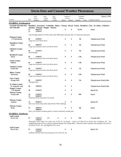
FLORIDA, NortheasternFLZ020>025-030>033- Hamilton - Suwannee - Columbia - Baker - Nassau - Duval - Union - Bradford - Clay - St. Johns - Gilchrist -035>038-040Alachua - Putnam - Flagler - Marion01310001EST2359ESTTotal flooding related to El Nino, More than 2800 homes <strong>and</strong> more than 175 businesses destroyed.Putnam County2 N Interlachen 08 1030EST0 0 3KThunderstorm WindLarge trees were blown down.Hamilton CountyJasper08 2005EST0 0 2KThunderstorm WindLarge trees <strong>and</strong> power lines were blown down.Gilchrist CountyBell08 2115EST0 0 5KThunderstorm WindRoof DamageBradford CountyStarke08 2140EST0 0 1.5KThunderstorm WindLarge trees <strong>and</strong> power lines were blown down.Union CountyRaiford08 2140EST0 0 1.5KThunderstorm WindLarge trees <strong>and</strong> power lines were blown down.Alachua CountyGainesville08 2145EST0 0 3KThunderstorm WindLarge trees <strong>and</strong> power lines were blown down.Baker CountyMacclenny08 2145EST0 0 2.5KThunderstorm WindLarge trees <strong>and</strong> power lines were blown down.Clay CountyOrange Park08 2245EST0 0 5KThunderstorm Wind (G60)Damaged signs.St. Johns CountySt Augustine Arpt 08 2250EST0 0Thunderstorm Wind (G60)Flagler County6 W Bunnell 08 2310EST0 0Hail (0.75)Marion CountyCountywide18191130EST0200EST0 0 30KFloodNumerous streets <strong>and</strong> roads were closed.Marion CountyAnthony19 0920EST0 0Hail (0.75)Hail was 6 inches deep inches deep North of Silver Springs.Marion CountyOcala19 1600EST2000EST0 0 8KFloodHeavy rain caused a retention pond to overflow <strong>and</strong> flood a mobile park.FLORIDA, NorthwestGulf CountyPort St JoeGulf CountyPort St Joe07<strong>Storm</strong> <strong>Data</strong> <strong>and</strong> <strong>Unusual</strong> <strong>Weather</strong> <strong>Phenomena</strong>TimePath PathNumber ofEstimatedLocal/ Length WidthPersonsDamageLocation DateSt<strong>and</strong>ard (Miles) (Yards) Killed Injured Property Crops Character of <strong>Storm</strong>1402EST1410EST0.7 .3 000025.5M35KFloodTornado (F0)Waterspout came ashore two miles east of Port St. Joe Beach. Condo roof lifted off on beach side of Highway 98. Twoneighboring houses <strong>and</strong> two vehicles sustained damage from flying debris. Numerous homes reported water damage in the Port St .Joe Beach, Port St. Joe, <strong>and</strong> Highl<strong>and</strong> View areas.07 1425EST01431ESTGolfball sized hail observed at beach just west of Port St. Joe.0Hail (1.75)March 199838 32


