

Storm Data and Unusual Weather Phenomena - CIG
Storm Data and Unusual Weather Phenomena - CIG
Storm Data and Unusual Weather Phenomena - CIG
- No tags were found...

Create successful ePaper yourself
Turn your PDF publications into a flip-book with our unique Google optimized e-Paper software.
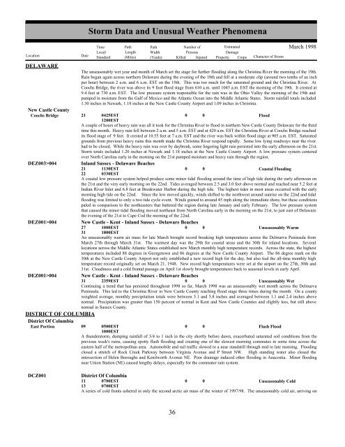
DELAWARENew Castle CountyCoochs BridgeDEZ003>004DEZ001>004DEZ001>004DISTRICT OF COLUMBIADistrict Of ColumbiaEast Portion<strong>Storm</strong> <strong>Data</strong> <strong>and</strong> <strong>Unusual</strong> <strong>Weather</strong> <strong>Phenomena</strong>TimePath PathNumber ofEstimatedLocal/ Length WidthPersonsDamageLocation DateSt<strong>and</strong>ard (Miles) (Yards) Killed Injured Property Crops Character of <strong>Storm</strong>March 1998The unseasonably wet year <strong>and</strong> month of March set the stage for further flooding along the Christina River the morning of the 19th.Rain began again across northern Delaware during the evening of the 18th <strong>and</strong> fell at a moderate clip (around two tenths of an inchper hour) between 2 a.m. <strong>and</strong> 6 a.m. EST on the 19th. This was too much for the saturated ground <strong>and</strong> the Christina River. AtCoochs Bridge, the river was above its 9 foot flood stage from 610 a.m. until 1045 a.m. EST the morning of the 19th. It crested at9.4 feet at 730 a.m. EST. The low pressure system responsible for the rain was in the Ohio Valley the morning of the 19th <strong>and</strong>pumped in moisture from the Gulf of Mexico <strong>and</strong> the Atlantic Ocean into the Middle Atlantic States. <strong>Storm</strong> rainfall totals included1.30 inches in Newark, 1.18 inches at the New Castle County Airport <strong>and</strong> 1.09 inches in Christina.21 0425EST0 0Flood1200ESTA couple of hours of heavy rain was all it took for the Christina River to flood in northern New Castle County Delaware for the thirdtime this month. Heavy rain fell between 2 a.m. <strong>and</strong> 5 a.m. EST <strong>and</strong> at 420 a.m. EST the Christina River at Coochs Bridge reachedits flood stage of 9 feet. It crested at 10.55 feet at 7 a.m. EST <strong>and</strong> the river was back within flood stage at 905 a.m. EST. Saturatedgrounds from previous heavy rains this month made the Christina River respond rapidly. Some low lying roadways near the riverhad to be closed. While the heavy rain was over by daybreak, some lingering light rain persisted into the early afternoon on the 21st.<strong>Storm</strong> totals included 1.20 inches at Newark <strong>and</strong> 1.18 inches at the New Castle County Airport. A low pressure system centeredover North Carolina early in the morning on the 21st pumped moisture <strong>and</strong> heavy rain through the region.Inl<strong>and</strong> Sussex - Delaware Beaches21 1130EST0 0Coastal Flooding22 0330ESTA coastal low pressure system helped produce some minor tidal flooding around the time of high tide during the early afternoon onthe 21st <strong>and</strong> the very early morning on the 22nd. Tides averaged between 2.5 <strong>and</strong> 3.0 feet above normal <strong>and</strong> reached near 5.2 feet atIndian River Inlet <strong>and</strong> 6.8 feet at Breakwater Harbor during the high tide. The highest tides in most areas occurred with the earlymorning high tide on the 22nd. Since the low moved quickly, winds shifted to the northwest around sunrise on the 22nd <strong>and</strong> tidalflooding was limited to only a two tide cycle event. Winds gusted to around 45 mph along the immediate shore, but these conditionspaled in comparison to the northeasters that battered the region during late January <strong>and</strong> early February. The low pressure systemthat caused the minor tidal flooding moved northeast from North Carolina early in the morning on the 21st, to just east of Delawarethe evening of the 21st to Cape Cod the morning of the 22nd.New Castle - Kent - Inl<strong>and</strong> Sussex - Delaware Beaches27 1000EST0 0Unseasonably Warm31 1800ESTAn unseasonably warm air mass for late March brought record breaking high temperatures across the Delmarva Peninsula fromMarch 27th through March 31st. The warmest day was the 29th for coastal areas <strong>and</strong> the 30th for inl<strong>and</strong> locations. Severallocations across the Middle Atlantic States established new March monthly high temperature records. Across the state, the highesttemperatures included 88 degrees in Georgetown <strong>and</strong> 86 degrees at the New Castle County Airport. The 86 degree mark on the30th at the New Castle County Airport not only established a new record high for the day, but also tied the all-time monthly hightemperature record originally set on March 21, 1948. New record high temperatures were set at the airport on the 27th, 30th <strong>and</strong>31st. Cloudiness <strong>and</strong> a cold frontal passage on April 1st slowly brought temperatures back to seasonal levels in early April.New Castle - Kent - Inl<strong>and</strong> Sussex - Delaware Beaches31 2359EST0 0Unseasonably WetContinuing a trend that has persisted throughout 1998 so far, March 1998 was an unseasonably wet month across the DelmarvaPeninsula. This led to the Christina River in New Castle County reaching flood stage three times during the month. On a countyweighted average, monthly precipitation totals were between 5.1 <strong>and</strong> 5.8 inches <strong>and</strong> averaged between 1.1 <strong>and</strong> 2.4 inches abovenormal. Precipitation was greater than 150 percent of normal in Kent <strong>and</strong> New Castle Counties <strong>and</strong> slightly less, but still abovenormal in Sussex County.09 0500EST0 0Flash Flood1000ESTA thunderstorm, dumping rainfall of 3/4 to 1 inch in the city shortly before dawn, exacerbated saturated soil conditions from theprevious week's rains, causing spotty flash flooding <strong>and</strong> creating one of the slowest morning commutes in some time across theeastern half of the metropolitan area. Automobile <strong>and</strong> rail traffic slowed to a near st<strong>and</strong>still through mid to late morning. Floodingclosed a stretch of Rock Creek Parkway between Virginia Avenue <strong>and</strong> P Street NW. High st<strong>and</strong>ing water also closed theintersection of Helen Boroughs <strong>and</strong> Kenilworth Avenue NE. Poor drainage induced other flooding in Anacostia. Minor floodingnear Union Station (NE) caused lengthy delays, especially for the commuter rain system.DCZ001District Of Columbia11130700EST0700EST0 0Unseasonably ColdA series of cold fronts ushered in only the second arctic air mass of the winter of 1997/98. The unseasonably cold air, arriving on36 30


