Storm Data and Unusual Weather Phenomena - CIG
Storm Data and Unusual Weather Phenomena - CIG
Storm Data and Unusual Weather Phenomena - CIG
- No tags were found...
Create successful ePaper yourself
Turn your PDF publications into a flip-book with our unique Google optimized e-Paper software.
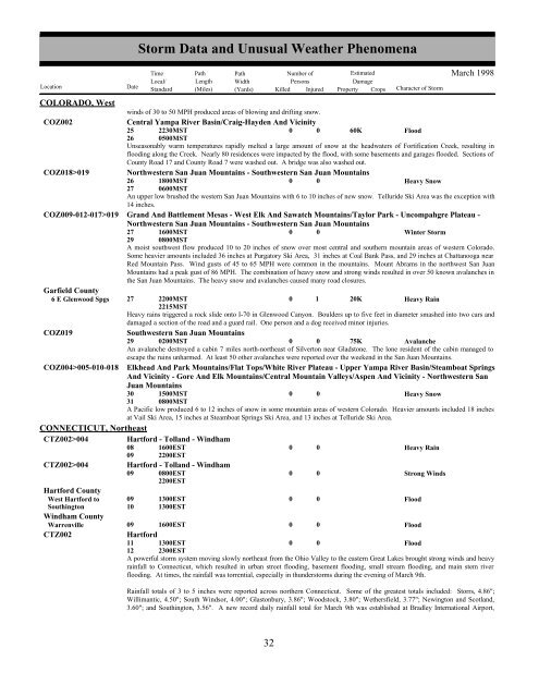
COLORADO, Westwinds of 30 to 50 MPH produced areas of blowing <strong>and</strong> drifting snow.COZ002Central Yampa River Basin/Craig-Hayden And Vicinity25262230MST0500MST0 0 60KFloodUnseasonably warm temperatures rapidly melted a large amount of snow at the headwaters of Fortification Creek, resulting inflooding along the Creek. Nearly 80 residences were impacted by the flood, with some basements <strong>and</strong> garages flooded. Sections ofCounty Road 17 <strong>and</strong> County Road 7 were washed out. A bridge was also washed out.COZ018>019 Northwestern San Juan Mountains - Southwestern San Juan Mountains26271800MST0600MST0 0Heavy SnowAn upper low brushed the western San Juan Mountains with 6 to 10 inches of new snow. Telluride Ski Area was the exception with14 inches.COZ009-012-017>019 Gr<strong>and</strong> And Battlement Mesas - West Elk And Sawatch Mountains/Taylor Park - Uncompahgre Plateau -Northwestern San Juan Mountains - Southwestern San Juan Mountains27291600MST0800MST0 0Winter <strong>Storm</strong>A moist southwest flow produced 10 to 20 inches of snow over most central <strong>and</strong> southern mountain areas of western Colorado.Some heavier amounts included 36 inches at Purgatory Ski Area, 31 inches at Coal Bank Pass, <strong>and</strong> 29 inches at Chattanooga nearRed Mountain Pass. Wind gusts of 45 to 65 MPH were common in the mountains. Mount Abrams in the northwest San JuanMountains had a peak gust of 86 MPH. The combination of heavy snow <strong>and</strong> strong winds resulted in over 50 known avalanches inthe San Juan Mountains. The heavy snow <strong>and</strong> avalanches caused many road closures.Garfield County6 E Glenwood Spgs 27 2200MST2215MST0 1 20KHeavy RainHeavy rains triggered a rock slide onto I-70 in Glenwood Canyon. Boulders up to five feet in diameter smashed into two cars <strong>and</strong>damaged a section of the road <strong>and</strong> a guard rail. One person <strong>and</strong> a dog received minor injuries.COZ019Southwestern San Juan Mountains29 0200MST0 0 75KAvalancheAn avalanche destroyed a cabin 7 miles north-northeast of Silverton near Gladstone. The lone resident of the cabin managed toescape the ruins unharmed. At least 50 other avalanches were reported over the weekend in the San Juan Mountains.COZ004>005-010-018 Elkhead And Park Mountains/Flat Tops/White River Plateau - Upper Yampa River Basin/Steamboat SpringsAnd Vicinity - Gore And Elk Mountains/Central Mountain Valleys/Aspen And Vicinity - Northwestern SanJuan Mountains30311500MST0800MST0 0Heavy SnowA Pacific low produced 6 to 12 inches of snow in some mountain areas of western Colorado. Heavier amounts included 18 inchesat Vail Ski Area, 15 inches at Steamboat Springs Ski Area, <strong>and</strong> 13 inches at Telluride Ski Area.CONNECTICUT, NortheastCTZ002>004CTZ002>004Hartford CountyWest Hartford toSouthingtonWindham CountyWarrenvilleCTZ002Hartford - Toll<strong>and</strong> - Windham08 1600EST09 2200ESTHartford - Toll<strong>and</strong> - Windham09 0800EST2200EST0910<strong>Storm</strong> <strong>Data</strong> <strong>and</strong> <strong>Unusual</strong> <strong>Weather</strong> <strong>Phenomena</strong>TimePath PathNumber ofEstimatedLocal/ Length WidthPersonsDamageLocation DateSt<strong>and</strong>ard (Miles) (Yards) Killed Injured Property Crops Character of <strong>Storm</strong>1300EST1300EST000000Heavy RainStrong Winds09 1600EST0 0FloodHartford11 1300EST0 0Flood12 2300ESTA powerful storm system moving slowly northeast from the Ohio Valley to the eastern Great Lakes brought strong winds <strong>and</strong> heavyrainfall to Connecticut, which resulted in urban street flooding, basement flooding, small stream flooding, <strong>and</strong> main stem riverflooding. At times, the rainfall was torrential, especially in thunderstorms during the evening of March 9th.Rainfall totals of 3 to 5 inches were reported across northern Connecticut. Some of the greatest totals included: Storrs, 4.86";Willimantic, 4.50"; South Windsor, 4.00"; Glastonbury, 3.86"; Woodstock, 3.80"; Wethersfield, 3.77"; Newington <strong>and</strong> Scotl<strong>and</strong>,3.60"; <strong>and</strong> Southington, 3.56". A new record daily rainfall total for March 9th was established at Bradley International Airport,FloodMarch 199832 26


