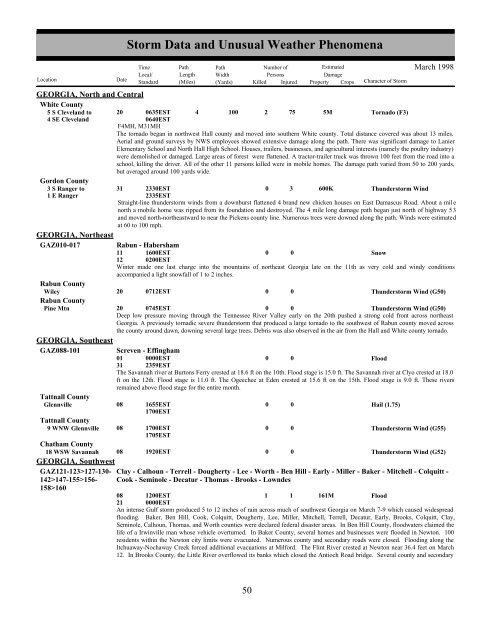
GEORGIA, North <strong>and</strong> CentralWhite County5 S Clevel<strong>and</strong> to 20 0635EST4 SE Clevel<strong>and</strong>4 100 2 75 5MTornado (F3)0640ESTF4MH, M31MHThe tornado began in northwest Hall county <strong>and</strong> moved into southern White county. Total distance covered was about 13 miles.Aerial <strong>and</strong> ground surveys by NWS employees showed extensive damage along the path. There was significant damage to LanierElementary School <strong>and</strong> North Hall High School. Houses, trailers, businesses, <strong>and</strong> agricultural interests (namely the poultry industry)were demolished or damaged. Large areas of forest were flattened. A tractor-trailer truck was thrown 100 feet from the road into aschool, killing the driver. All of the other 11 persons killed were in mobile homes. The damage path varied from 50 to 200 yards,but averaged around 100 yards wide.Gordon County3 S Ranger to 31 2330EST0 3 600KThunderstorm Wind1 E Ranger2335ESTStraight-line thunderstorm winds from a downburst flattened 4 br<strong>and</strong> new chicken houses on East Damascus Road. About a mil enorth a mobile home was ripped from its foundation <strong>and</strong> destroyed. The 4 mile long damage path began just north of highway 53<strong>and</strong> moved north-northeastward to near the Pickens county line. Numerous trees were downed along the path. Winds were estimatedat 60 to 100 mph.GEORGIA, NortheastGAZ010-017Rabun CountyWileyRabun CountyPine MtnGEORGIA, SoutheastGAZ088-101Tattnall CountyGlennvilleRabun - Habersham11121600EST0200EST0 0SnowWinter made one last charge into the mountains of northeast Georgia late on the 11th as very cold <strong>and</strong> windy conditionsaccompanied a light snowfall of 1 to 2 inches.200712EST00Thunderstorm Wind (G50)20 0745EST0 0Thunderstorm Wind (G50)Deep low pressure moving through the Tennessee River Valley early on the 20th pushed a strong cold front across northeastGeorgia. A previously tornadic severe thunderstorm that produced a large tornado to the southwest of Rabun county moved acrossthe county around dawn, downing several large trees. Debris was also observed in the air from the Hall <strong>and</strong> White county tornado.Screven - Effingham01310000EST2359EST0 0FloodThe Savannah river at Burtons Ferry crested at 18.6 ft on the 10th. Flood stage is 15.0 ft. The Savannah river at Clyo crested at 18.0ft on the 12th. Flood stage is 11.0 ft. The Ogeechee at Eden crested at 15.6 ft on the 15th. Flood stage is 9.0 ft. These riversremained above flood stage for the entire month.08<strong>Storm</strong> <strong>Data</strong> <strong>and</strong> <strong>Unusual</strong> <strong>Weather</strong> <strong>Phenomena</strong>TimePath PathNumber ofEstimatedLocal/ Length WidthPersonsDamageLocation DateSt<strong>and</strong>ard (Miles) (Yards) Killed Injured Property Crops Character of <strong>Storm</strong>1655EST1700EST00Hail (1.75)March 1998Tattnall County9 WNW Glennville 08 1700EST1705EST0 0Thunderstorm Wind (G55)Chatham County18 WSW Savannah 08 1920EST0 0Thunderstorm Wind (G52)GEORGIA, SouthwestGAZ121-123>127-130-142>147-155>156-Clay - Calhoun - Terrell - Dougherty - Lee - Worth - Ben Hill - Early - Miller - Baker - Mitchell - Colquitt -Cook - Seminole - Decatur - Thomas - Brooks - Lowndes158>16008211200EST0000EST1 1 161MFloodAn intense Gulf storm produced 5 to 12 inches of rain across much of southwest Georgia on March 7-9 which caused widespreadflooding. Baker, Ben Hill, Cook, Colquitt, Dougherty, Lee, Miller, Mitchell, Terrell, Decatur, Early, Brooks, Colquitt, Clay,Seminole, Calhoun, Thomas, <strong>and</strong> Worth counties were declared federal disaster areas. In Ben Hill County, floodwaters claimed thelife of a Irwinville man whose vehicle overturned. In Baker County, several homes <strong>and</strong> businesses were flooded in Newton. 100residents within the Newton city limits were evacuated. Numerous county <strong>and</strong> secondary roads were closed. Flooding along theItchuaway-Nochaway Creek forced additional evacuations at Milford. The Flint River crested at Newton near 36.4 feet on March12. In Brooks County, the Little River overflowed its banks which closed the Antioch Road bridge. Several county <strong>and</strong> secondary50 44
GEORGIA, Southwestroads were closed. In Calhoun <strong>and</strong> Clay counties, several schools were closed due to dangerous road conditions. In ColquittCounty, 25 residents were evacuated. Hardest hit areas were along Indian Creek, Indian Lake, <strong>and</strong> Bear Creek. 75 county <strong>and</strong>secondary roads were closed. The Camilla Road bridge was closed to high water in Moultrie. Several Moultrie Housing Authorityresidents were displaced <strong>and</strong> a few streets in Norman Park were flooded. In Cook County, several county <strong>and</strong> secondary roads werewashed out. In Decatur County, approximately 185 families evacuated their homes in the Flint River Heights <strong>and</strong> Riverdalesubdivisions of Bainbridge. 20 county roads <strong>and</strong> 60 homes were damaged. Spring Creek overflowed its banks closing US Highway84 at Brinson. The Elberta Crate Company lumber yard sustained flood damage. Floodwaters submerged much of West Bainbridgeas well as several factories, businesses, <strong>and</strong> homes. The Flint River crested near 34.7 feet at Bainbridge on March 13. InDougherty County, nearly 11,000 residents were evacuated in Albany. Several city <strong>and</strong> county roads were flooded. An estimated500 homes were damaged. Many city schools were closed including Albany College. Waters overflowed the right bank levee into adownstream housing development. The Flint River creested at 36.9 feet (third highest) on March 11. In Early County, Long BranchCreek flooded 30 homes at Damascus. Several homes in Saffold <strong>and</strong> Jakin were flooded. One man was injured whe he drove hisvehicle through a barricade at Cedar Springs. Numerous county <strong>and</strong> secondary roads were closed. In Lee County, portions of USHighway 19 were closed to floodwaters. The Muckalee Creek crested near 17.1 feet at Leesburg on March 9. A few homessustained minor flooding in the North Hampton subdivision (7 miles downstream from the river gage). In Lowndes County,Skipper Bridge, Little River, <strong>and</strong> Franklinville Roads flooded. Some houses along the Little River sustained minor flood damage.Portions of Valdosta flooded, especially along the right bank of the Withlacoochee River which crested at 22.5 feet on March 11. InMiller County, Spring Creek <strong>and</strong> some streams overflowed their banks. Numerous county <strong>and</strong> dirt roads were impassable. 10,000gallons of raw sewage spilled into south Colquitt <strong>and</strong> some city streets were flooded. In Mitchell County, high waters closednumerous roads as county creeks <strong>and</strong> streams overflowed their banks. In Seminole County, several secondary <strong>and</strong> state roads wereclosed along Spring Creek <strong>and</strong> Fishpond Drain. In Terrell County, 19 county roads <strong>and</strong> State Highway 55 were impassable.Numerous creeks <strong>and</strong> tributaries overran their banks. Homes along the lower Kinchafoonee Road <strong>and</strong> creek were damaged as wellas residences on Century Road in Dawson. The Kinchafoonee Creek at Dawson crested near 21.7 feet on March 10. In ThomasCounty, homes along the Ochlockonee River were evacuated as levels exceeded 18 feet <strong>and</strong> road access was impossible. Houses<strong>and</strong> trailers had water up to the doorsteps in the Lake Riverside <strong>and</strong> Stewart Avenue areas. The Ochlockonee River crested atThomasville near 22 feet on March 10. In Worth County, 150 county <strong>and</strong> secondary roads were washed out.M32VEGAZ142EarlyCalhoun CountyLearyEarly CountyBlakelyGEORGIA, West CentralGAZ089HAWAIIHIZ002>005<strong>Storm</strong> <strong>Data</strong> <strong>and</strong> <strong>Unusual</strong> <strong>Weather</strong> <strong>Phenomena</strong>TimePath PathNumber ofEstimatedLocal/ Length WidthPersonsDamageLocation DateSt<strong>and</strong>ard (Miles) (Yards) Killed Injured Property Crops Character of <strong>Storm</strong>08 1210EST0 0 1KHigh WindLarge pine trees down across rairoad tracks at intersection of Rock Hill <strong>and</strong> Friendship Roads (approximately 2 miles east ofHilton).08 1230EST0 0Hail (1.25)1300ESTGolfball sized hail in Leary. Central Georgia Rail tracks washed out between Leary <strong>and</strong> Arlington. Flooding reported at theintersection of Highways 62 <strong>and</strong> 55.19 1900EST01910ESTDime sized hail observed in Blakely <strong>and</strong> 6 miles south of Blakely.0Hail (0.75)Muscogee08 0945CST1500CST0 0 30K 0 FloodMinor flooding occurred along the Chattahoochee River in Columbus, causing a park to get flooded.March 1998Oahu - Maui - Isl<strong>and</strong> Of Hawaii - Molokai01310000HST2359HST0 0DroughtThis was the third driest March on record in Honolulu since record keeping began in 1874. This was also the third driest Januarythrough March period for Honolulu since 1874.Below average precipitation occurred statewide in March, with all first order <strong>and</strong> all automated rain gauges receiving less thanaverage rainfall. Sixty-seven of the 73 rain gauges reported less than 50 percent of average for the month, while 35 received lessthan 25 percent of average. This continued the six month trend of drier than usual conditions for the entire state.In the first half of March, weather patterns were dominated by a strong upper level jet stream across the Pacific Ocean north of theisl<strong>and</strong>s <strong>and</strong> multiple periods with upper level ridges over <strong>and</strong> to the west of the state. These combinations of phenomenaresponsible for the rainfall shortage are indicative of how El Nino affects weather in the state of Hawaii.51 45
- Page 1: MARCH 1998VOLUME 40NUMBER 3STORMDAT
- Page 5 and 6: OUTSTANDING STORMS OF THE MONTH1. T
- Page 7 and 8: ALABAMA, North CentralLamar CountyS
- Page 9 and 10: ALABAMA, North CentralMadison Count
- Page 11 and 12: ALABAMA, SoutheastALZ065-068Coffee
- Page 13 and 14: Storm Data and Unusual Weather Phen
- Page 15 and 16: ALASKA, SouthernAKZ011-018>019AKZ02
- Page 17 and 18: ARIZONA, NorthwestMohave County20 N
- Page 19 and 20: ARKANSAS, Central and North Central
- Page 21 and 22: ARKANSAS, NorthwestMadison CountyHu
- Page 23 and 24: CALIFORNIA, NorthwestCAZ003-076Nort
- Page 25 and 26: CALIFORNIA, South CentralKern Count
- Page 27 and 28: CALIFORNIA, SouthwestSan Bernardino
- Page 29 and 30: CALIFORNIA, West South CentralVentu
- Page 31 and 32: COLORADO, South Central and Southea
- Page 33 and 34: Storm Data and Unusual Weather Phen
- Page 35 and 36: Storm Data and Unusual Weather Phen
- Page 37 and 38: Storm Data and Unusual Weather Phen
- Page 39 and 40: FLORIDA, NorthwestBay CountyMexico
- Page 41 and 42: FLORIDA, West CentralDe Soto County
- Page 43 and 44: FLORIDA, West CentralManatee County
- Page 45 and 46: FLORIDA, West CentralPasco CountySt
- Page 47 and 48: FLORIDA, West Panhandlecaused sand
- Page 49: GEORGIA, LowerGEORGIA, North and Ce
- Page 53 and 54: Storm Data and Unusual Weather Phen
- Page 55 and 56: IDAHO, SouthwestTwin Falls County2
- Page 57 and 58: ILLINOIS, CentralMoultrie CountyLov
- Page 59 and 60: ILLINOIS, SouthILZ087-092>094ILZ084
- Page 61 and 62: Storm Data and Unusual Weather Phen
- Page 63 and 64: IOWA, CentralWapello County2 W Ottu
- Page 65 and 66: KANSAS, EastMarshall CountyMarysvil
- Page 67 and 68: KANSAS, NorthwestHail accompanied b
- Page 69 and 70: KANSAS, SouthwestRush County14 WSW
- Page 71 and 72: LOUISIANA, NortheastCatahoula Paris
- Page 73 and 74: LOUISIANA, SoutheastSt. John The Ba
- Page 75 and 76: MAINEHancock CountyCountywidePenobs
- Page 77 and 78: Storm Data and Unusual Weather Phen
- Page 79 and 80: MARYLAND, WestBlustery northwest wi
- Page 81 and 82: MASSACHUSETTS, Central and EastMAZ0
- Page 83 and 84: MICHIGAN, EastMacomb CountyUticaSag
- Page 85 and 86: MICHIGAN, WestMIZ074MIZ037-043-056-
- Page 87 and 88: MINNESOTA, Central and South Centra
- Page 89 and 90: MINNESOTA, SoutheastOlmsted CountyS
- Page 91 and 92: MISSISSIPPI, CentralSmith CountyMiz
- Page 93 and 94: MISSISSIPPI, NorthYalobusha CountyW
- Page 95 and 96: MISSOURI, EastJefferson CountyCount
- Page 97 and 98: Storm Data and Unusual Weather Phen
- Page 99 and 100: Storm Data and Unusual Weather Phen
- Page 101 and 102:
Storm Data and Unusual Weather Phen
- Page 103 and 104:
MISSOURI, SouthwestPulaski County2
- Page 105 and 106:
MISSOURI, SouthwestMaries CountyCou
- Page 107 and 108:
MONTANA, EastMTZ016>017-021>023-025
- Page 109 and 110:
NEBRASKA, CentralMcpherson CountyFl
- Page 111 and 112:
NEBRASKA, WestGolf ball size hail f
- Page 113 and 114:
NEW HAMPSHIRE, North and CentralNHZ
- Page 115 and 116:
NEW JERSEY, South and NorthwestCumb
- Page 117 and 118:
Storm Data and Unusual Weather Phen
- Page 119 and 120:
NEW MEXICO, SoutheastLea CountyHobb
- Page 121 and 122:
NEW YORK, CoastalNYZ069NEW YORK, Ea
- Page 123 and 124:
Storm Data and Unusual Weather Phen
- Page 125 and 126:
NORTH CAROLINA, CentralDime size ha
- Page 127 and 128:
NORTH CAROLINA, CentralGolfball siz
- Page 129 and 130:
NORTH CAROLINA, Northwest and North
- Page 131 and 132:
NORTH CAROLINA, SouthwestDeep low p
- Page 133 and 134:
OHIO, NorthOHZ009>014-019>023-028>0
- Page 135 and 136:
Storm Data and Unusual Weather Phen
- Page 137 and 138:
OKLAHOMA, PanhandleOKZ002TexasOKZ00
- Page 139 and 140:
OKLAHOMA, Western, Central and Sout
- Page 141 and 142:
OKLAHOMA, Western, Central and Sout
- Page 143 and 144:
PENNSYLVANIA, CentralAdams CountyCo
- Page 145 and 146:
PENNSYLVANIA, Easta couple of inche
- Page 147 and 148:
RHODE ISLANDKent CountyWest Warwick
- Page 149 and 150:
SOUTH CAROLINA, North CoastalREPORT
- Page 151 and 152:
SOUTH DAKOTA, WestSDZ001-012-012>01
- Page 153 and 154:
TEXAS, CentralConcho CountyPaint Ro
- Page 155 and 156:
TEXAS, NorthStorm Data and Unusual
- Page 157 and 158:
TEXAS, NorthTarrant County1 W Crowl
- Page 159 and 160:
TEXAS, NortheastHarrison County1 W
- Page 161 and 162:
TEXAS, South CentralMedina CountySt
- Page 163 and 164:
TEXAS, Western NorthWichita CountyW
- Page 165 and 166:
Storm Data and Unusual Weather Phen
- Page 167 and 168:
Storm Data and Unusual Weather Phen
- Page 169 and 170:
VIRGINIA, NorthCulpeper CountyCount
- Page 171 and 172:
VIRGINIA, SouthwestPittsylvania Cou
- Page 173 and 174:
WEST VIRGINIA, EastA mudslide affec
- Page 175 and 176:
WISCONSIN, NortheastWaushara County
- Page 177 and 178:
Storm Data and Unusual Weather Phen
- Page 179 and 180:
WISCONSIN, SouthwestLa Crosse Count
- Page 181 and 182:
Storm Data and Unusual Weather Phen
- Page 186:
To change your address, please retu


