Storm Data and Unusual Weather Phenomena - CIG
Storm Data and Unusual Weather Phenomena - CIG
Storm Data and Unusual Weather Phenomena - CIG
- No tags were found...
You also want an ePaper? Increase the reach of your titles
YUMPU automatically turns print PDFs into web optimized ePapers that Google loves.
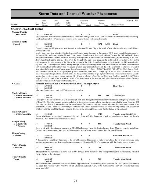
CALIFORNIA, South CentralMerced County1 SW Planada 25 0300PST0 0FloodEight (8) homes just outside of Planada sustained some flood damage from Miles Creek from heavy shower/thundershower activity .Unofficial rainfall of 1.3" in one hour occurred in the area (with rain continuing afterward).Merced CountyMerced 25 0530PST1300PST0 0 9.6M 1.5M FloodOver 65 homes <strong>and</strong> 19 apartments were flooded in <strong>and</strong> around Merced City as the result of torrential/record-setting rainfall in theprevious 18 hours.Locally heavy rain from a b<strong>and</strong> of thunderstorms that became quasi-stationary in the previous 12-18 hours brought flooding again tothe Merced City <strong>and</strong> some outlying Merced County areas. Thunderstorms developed mid-day Tuesday the 24th <strong>and</strong> locally heavyrain continued for much of that afternoon <strong>and</strong> early evening hours. Rainfall totals for 24 hours ending by the morning of the 25thshowed unofficial reports from 3.5" to 5.9" in the Merced City area. One gauge in the north part of town showed 6.8" in the48-hour period from the evening of the 23rd to the evening of the 25th. The official gauge at the airport for the 24th as a calendarday was 3.25"! Although skies cleared during the night of the 24th/morning of the 25th, runoff water did not reach creeks until theearly morning hours of the 25th with a subsequent crest on Bear Creek after dawn on the 25th. Over 1000 people were evacuatedfrom Merced City <strong>and</strong> nearby County areas. Bear Creek crested at 19.3 feet / 7653 CFS at 0900 PST 3/25/98...Black Rascal Creekwas contributed 4449CFS(148% capacity) early on 3/25 to Bear Creek's total. Damage figures for the 24th/25th assessed at $9.6Mdue to flooding with agricultural amounts of $1.5M being tentative (likely to go higher with time). This event in Merced Countywas the 2nd one-in-100 event in two months. Dry Creek, a tributary of the Merced River near Snelling, reached 5358CFS at aheight of 15.4' at 1800PST on 3/24/98 as a result of the heavy rains in the area <strong>and</strong> indicative of the type of stream flows from thefoothills of the S.Sierra Nevada onto the valley floor.CAZ022Southern Sierra Nevada-Yosemite National Park To Kings Canyon24251200PST0600PST0 0Heavy SnowMammoth Mountain received 14-18" of new snow overnight.Madera County5 WSW Chowchilla to 24 1346PST 2 25 0 0 15K 30K Tornado (F0)3 WSW Chowchilla1356PSTInitial part of this severe storm was 2 miles in length with trees damaged in the Maddalena Orchard south of Highway 152 <strong>and</strong> eastof Road 10. No other damage seen immediately to the northeast except phone line damage immediately along Highway 152through the rural area. A spotter observed the tornado path. While not seen directly by any witnesses there was some damage to a norchard at Ave 251/2 <strong>and</strong> Road 14 located just south <strong>and</strong> west 2 miles from Chowchilla <strong>and</strong> some building damage 2 miles due westof Chowchilla that would be the same line <strong>and</strong> direction as the observed tornado...but 4 miles farther to the northeast!Madera County5 WSW Chowchilla 24 1355PST0 0 1.5KThunderstorm Wind (G50)Strong wind from a severe thunderstorm pushed a trailer house off of its foundation as well as damaging some dairy, calf sheds inan area 1/2 mile north of the storm's tornado track.Kings County3 S Hanford to 24 1440PST0 0 50KThunderstorm Wind1 N Armona1500PSTGusty wind with a thunderstorm measured at 42 MPH at Lemoore Naval Air Station brought down 32 power poles in north KingsCounty. the power company indicated 20,000 customers were affected by the downed lines for up to 12 hours.Kings CountyLemoore24 1445PST1600PST0 0Urban/Sml Stream FldA thunderstorm brought very heavy rain to the city of Lemoore. The amount of water overwhelmed the city drain system <strong>and</strong> waterwent gutter to gutter across downtown business area streets. Reports of 1.78" of rain occurred with the thunderstorm's passage.Tulare CountyPortervilleTulare CountyTulare<strong>Storm</strong> <strong>Data</strong> <strong>and</strong> <strong>Unusual</strong> <strong>Weather</strong> <strong>Phenomena</strong>TimePath PathNumber ofEstimatedLocal/ Length WidthPersonsDamageLocation DateSt<strong>and</strong>ard (Miles) (Yards) Killed Injured Property Crops Character of <strong>Storm</strong>March 199824 1600PST0 0 5KThunderstorm Wind1700PSTThunderstorm wind (estimated at more than 37Kts) brought down powerlines <strong>and</strong> damaged the roof of an elementary school inPorterville late in the afternoon.24 1600PST0 0 50KThunderstorm Wind1700PSTThunderstorm wind (estimated at more than 35Kts) toppled trees in Tulare causing power problems for 15,000 power customers inthe South San Joaquin Valley. One tree fell on a home in southeast Tulare. Total rainfall in the Tulare area with the rain/win dstorm was 1.36".24 18


