

Storm Data and Unusual Weather Phenomena - CIG
Storm Data and Unusual Weather Phenomena - CIG
Storm Data and Unusual Weather Phenomena - CIG
- No tags were found...

Create successful ePaper yourself
Turn your PDF publications into a flip-book with our unique Google optimized e-Paper software.
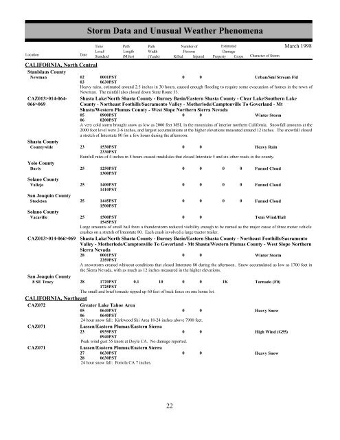
CALIFORNIA, North CentralStanislaus CountyNewman02030001PST0630PST0 0Urban/Sml Stream FldHeavy rains, estimated around 2.5 inches in 30 hours, caused enough flooding to require some evacuation of homes in the town ofNewman. The rainfall also closed down State Route 33.CAZ013>014-064-066>069Shasta Lake/North Shasta County - Burney Basin/Eastern Shasta County - Clear Lake/Southern LakeCounty - Northeast Foothills/Sacramento Valley - Motherlode/Camptonville To Goverl<strong>and</strong> - MtShasta/Western Plumas County - West Slope Northern Sierra Nevada05060900PST0200PST0 0Winter <strong>Storm</strong>A very cold storm brought snow as low as 2000 feet MSL in the mountains of interior northern California. Snowfall amounts at the2000 foot level were 2-6 inches, <strong>and</strong> largest accumulations at the higher elevations measured around 12 inches. The snowfall closeda stretch of Interstate 80 for a few hours during the afternoon.Shasta CountyCountywide23 1530PST2330PST0 0Heavy RainRainfall rates of 4 inches in 8 hours caused mudslides that closed Interstate 5 <strong>and</strong> six other roads in the county.Yolo CountyDavis 25 1250PST1300PST0 0 0 0 Funnel CloudSolano CountyVallejo 25 1400PST1410PST0 0 0 0 Funnel CloudSan Joaquin CountyStockton 25 1445PST1500PST0 0 0 0 Funnel CloudSolano CountyVacaville25 1500PST1545PST0 0Tstm Wind/HailLarge amounts of small hail from a thunderstorm reduced visibility enough to be named as the major cause of three motor vehiclecrashes on a stretch of Interstate 80. Each crash involved a large tractor trailer.CAZ013>014-066>069 Shasta Lake/North Shasta County - Burney Basin/Eastern Shasta County - Northeast Foothills/SacramentoValley - Motherlode/Camptonville To Goverl<strong>and</strong> - Mt Shasta/Western Plumas County - West Slope NorthernSierra Nevada28 0001PST2359PST0 0Winter <strong>Storm</strong>A snowstorm created whiteout conditions that closed Interstate 80 during the afternoon. Snow accumulated as low as 1700 feet inthe Sierra Nevada, with as much as 12 inches measured in the higher elevations.San Joaquin County8 SE Tracy 28 1720PST1725PST0.1 10 0 0 1KTornado (F0)The small <strong>and</strong> brief tornado ripped up 60 feet of back fence on one home lot.CALIFORNIA, NortheastCAZ072CAZ071CAZ071<strong>Storm</strong> <strong>Data</strong> <strong>and</strong> <strong>Unusual</strong> <strong>Weather</strong> <strong>Phenomena</strong>TimePath PathNumber ofEstimatedLocal/ Length WidthPersonsDamageLocation DateSt<strong>and</strong>ard (Miles) (Yards) Killed Injured Property Crops Character of <strong>Storm</strong>Greater Lake Tahoe Area05060640PST0640PST0 024 hour snow fall: Kirkwood Ski Area 18-24 inches above 7900 feet.Lassen/Eastern Plumas/Eastern Sierra23 0939PST0 00940PSTPeak wind gust 55 knots at Doyle CA. No damage reported.Lassen/Eastern Plumas/Eastern Sierra27 0630PST0 028 0630PST24 hour snow fall: Portola CA 7 inches.Heavy SnowHigh Wind (G55)Heavy SnowMarch 199822 16


