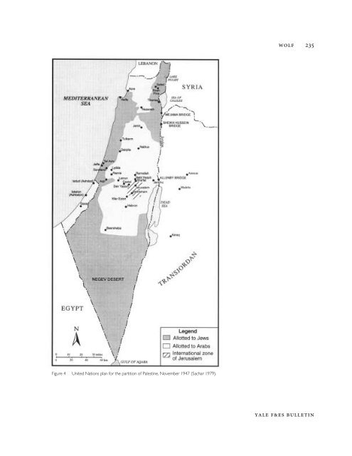
234 MIDDLE EASTERN NATURAL ENVIRONMENTS<strong>the</strong> territory of Palestine. The latter two territories were alreadyincluded in Zionist plans for water diversion <strong>and</strong> hydroelectricitygeneration. The arrangement was beneficial to Palestine’shydrostrategic positioning, <strong>and</strong>, although it was made mainly foradministrative reasons, “to make customs inspection easier,” it wasalso expressed that <strong>the</strong> development plans should proceed withoutinternational complication (Ra’anan 1955). Never<strong>the</strong>less, accordingto <strong>the</strong> agreement, fishing <strong>and</strong> navigation rights on <strong>the</strong> lake wereretained by <strong>the</strong> inhabitants of Syria. Later, between 1948 <strong>and</strong> 1967,Syria claimed <strong>the</strong> shoreline as <strong>the</strong> de facto border, <strong>and</strong> argued forriparian rights to <strong>the</strong> lake on that basis.At <strong>the</strong> Yarmuk, <strong>the</strong> border went eastward along <strong>the</strong> river, meetingup with <strong>the</strong> Sykes-Picot line into <strong>the</strong> Syrian desert <strong>and</strong> south of<strong>the</strong> Jebel Druze. The final agreement made no mention of jointaccess to French-controlled waters.Administrative divisions would fur<strong>the</strong>r convolute <strong>the</strong> boundariesalong <strong>the</strong> Jordan. In May 1921, Churchill offered <strong>the</strong> Emir Abdullahreign over that part of <strong>the</strong> British M<strong>and</strong>ate east of <strong>the</strong> Jordan River.Transjordan became a semi-independent entity in 1923 <strong>and</strong> anindependent kingdom in 1946. While <strong>the</strong> division was originallybetween administrative units under one authority—<strong>the</strong> BritishM<strong>and</strong>ate—<strong>the</strong> boundary, as defined by <strong>the</strong> center of <strong>the</strong> JordanRiver, <strong>the</strong> Dead Sea, <strong>and</strong> Wadi <strong>Arab</strong>a/Arava, would eventually become<strong>the</strong> international boundary between Israel <strong>and</strong> Jordan. 4Although <strong>the</strong> location of water resources had been an important,sometimes over-riding issue with some of <strong>the</strong> actors involved in determinationof <strong>the</strong> boundaries of <strong>the</strong>se territories, it is clear from <strong>the</strong> outcomethat o<strong>the</strong>r issues took precedence over <strong>the</strong> need for waterdevelopment. These o<strong>the</strong>r factors ranged from <strong>the</strong> geostrategic (<strong>the</strong>location of roads <strong>and</strong> oil pipelines) to <strong>the</strong> political (alliances <strong>and</strong> relationshipsamong British, French, Jews, <strong>and</strong> <strong>Arab</strong>s) to <strong>the</strong> historical (howwell versed one or ano<strong>the</strong>r negotiator was in biblical geography).4The boundary was originally defined as <strong>the</strong>location of <strong>the</strong> river in 1922. However,after <strong>the</strong> Jordan shifted 800 meterswestward during <strong>the</strong> winter of 1927-28,<strong>the</strong> British high commissioner decided that<strong>the</strong> boundary would henceforth be <strong>the</strong>center of <strong>the</strong> water bodies mentioned,wherever <strong>the</strong>y me<strong>and</strong>ered. A similar shift in<strong>the</strong> streambed, <strong>and</strong> consequently in <strong>the</strong>boundary, occurred in <strong>the</strong> winter of 1978-79 (Biger 1994).Partition <strong>and</strong> Jewish Statehood: 1922-1948During <strong>the</strong> 1930s <strong>and</strong> 1940s, water was a focus of several reportswhich tried to determine <strong>the</strong> “economic absorptive capacity” ofm<strong>and</strong>ate Palestine. In <strong>the</strong> absence of clear immigration policy, bothJewish <strong>and</strong> <strong>Arab</strong> residents of Palestine became increasingly frustrated,taking out <strong>the</strong>ir hostility on each o<strong>the</strong>r as well as on <strong>the</strong>British. Over time, <strong>the</strong> partition of Palestine into Jewish <strong>and</strong> <strong>Arab</strong>states increasingly became <strong>the</strong> most advocated option, first in anAnglo-American plan in 1946, <strong>and</strong> later, when Britain ceded <strong>the</strong>M<strong>and</strong>ate to <strong>the</strong> United Nations, in <strong>the</strong> U.N. Partition Plan of 1947.BULLETIN 103
WOLF 235Figure 4 United Nations plan for <strong>the</strong> partition of Palestine, November 1947 (Sachar 1979).YALE F&ES BULLETIN