240 MIDDLE EASTERN NATURAL ENVIRONMENTSThe Israel-Lebanon BoundaryIsrael had occupied Lebanese territory up to <strong>the</strong> Litani River, yetwithdrew its forces to <strong>the</strong> international boundary as a result of <strong>the</strong>Armistice Agreement. Amery (1996) suggests that Israel’s withdrawalwas based on <strong>the</strong> belief that it could make peace with aChristian-led Lebanon, <strong>and</strong> that joint Lebanese-Israeli water resourcesdevelopment could proceed without territorial annexation(citing Berger (1965) as arguing that Israel would not have withdrawnfrom sou<strong>the</strong>rn Lebanon had it not been convinced of <strong>the</strong>se results).The Israel-Syria BoundarySyria occupied about 60 km 2 of Israeli territory during <strong>the</strong> war atthree locations, as described above: (1) <strong>the</strong> Banias Springs area, (2)<strong>the</strong> Huleh Lake/Daughters of Jacob Bridge region, <strong>and</strong> (3) <strong>the</strong> trianglefrom El-Hama to <strong>the</strong> sou<strong>the</strong>astern shores of <strong>the</strong> Sea of Galilee.During <strong>the</strong> Armistice talks, Syria agreed to withdraw from all of thisterritory, save Givat Banias <strong>and</strong> El-Hama, provided that <strong>the</strong> remainingterritory would not be militarized by Israel. While both of <strong>the</strong>sewere included in Israeli water development plans, Israel did notpush for <strong>the</strong>ir return, given <strong>the</strong> presumed temporary nature of <strong>the</strong>Armistice Line.Neff (1994) suggests that Syria withdrew with <strong>the</strong> underst<strong>and</strong>ingthat final borders, including final sovereignty of <strong>the</strong> three demilitarizedzones (DMZs), would be negotiated in <strong>the</strong> future. Israel, incontrast, considered itself <strong>the</strong> legal sovereign of <strong>the</strong>se areas, legalheir to <strong>the</strong> nor<strong>the</strong>rn territory within <strong>the</strong> British m<strong>and</strong>ate.The Israel-Jordan BoundaryThe pre-war boundary between British-m<strong>and</strong>ate Palestine <strong>and</strong>Transjordan, delineated when Britain split Palestine in two in 1922,followed <strong>the</strong> middle of <strong>the</strong> Yarmuk River, <strong>the</strong> Jordan River, <strong>the</strong> DeadSea, <strong>and</strong> Wadi <strong>Arab</strong>a southward to <strong>the</strong> Gulf of Aqaba/Eilat (Biger1994). After <strong>the</strong> war, Jordan claimed jurisdiction over <strong>the</strong> West Bank.Nowhere is <strong>the</strong> assumption that <strong>the</strong> Armistice Line was to be temporarymore clear, however, than in <strong>the</strong> “Green Line” dividing <strong>the</strong> WestBank from Israel. While negotiations continued officially in Rhodes,Sachar (1979) describes secret meetings which took place directlybetween <strong>the</strong> Israelis <strong>and</strong> King Abdullah <strong>and</strong> his advisors at <strong>the</strong> king’swinter palace. The agreement which was reached was informed notonly by <strong>the</strong> location of <strong>the</strong> two armies at war’s end, but also by <strong>the</strong>location of roads <strong>and</strong> railways, as well as hilltops <strong>and</strong> high ground forlocal strategic advantage. The line, drawn in green on a map at a scaleof 1:250,000, 7 cut villages from <strong>the</strong>ir l<strong>and</strong>, divided towns from <strong>the</strong>7At that scale, <strong>the</strong> width of <strong>the</strong> line aloneallowed for territorial ambiguity of 250malong <strong>the</strong> boundary (Biger 1989).BULLETIN 103
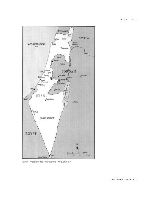
WOLF 241Figure 6 Rhodes armistice demarcation line, 1948 (Sachar 1978)YALE F&ES BULLETIN